
Clallam County, Washington facts for kids
Quick facts for kids
Clallam County
|
|||
|---|---|---|---|

|
|||
|
|||

Location within the U.S. state of Washington
|
|||
 Washington's location within the U.S. |
|||
| Country | |||
| State | |||
| Founded | April 26, 1854 | ||
| Seat | Port Angeles | ||
| Largest city | Port Angeles | ||
| Area | |||
| • Total | 2,671 sq mi (6,920 km2) | ||
| • Land | 1,738 sq mi (4,500 km2) | ||
| • Water | 932 sq mi (2,410 km2) 35%% | ||
| Population
(2020)
|
|||
| • Total | 77,155 | ||
| • Estimate
(2023)
|
77,616 |
||
| • Density | 44.4/sq mi (17.1/km2) | ||
| Time zone | UTC−8 (Pacific) | ||
| • Summer (DST) | UTC−7 (PDT) | ||
| Congressional district | 6th | ||


Clallam County is a cool place in Washington state, USA. It's located on the beautiful Olympic Peninsula. About 77,000 people live here.
The main city and county seat is Port Angeles. The name "Clallam" comes from the Klallam people. It means "the strong people." The county was officially formed on April 26, 1854.
Clallam County is right next to the Strait of Juan de Fuca. Across the strait is Vancouver Island in British Columbia, Canada! This county has a special history. For a long time, it voted for the winning candidate in almost every presidential election. This means it was very good at "predicting" who would win!
Contents
Exploring Clallam County's Land
Clallam County covers a total area of about 2,671 square miles. A big part of this area, about 932 square miles, is water!
This county is home to Cape Alava. This is the westernmost point in the entire contiguous United States. It's a really unique spot! Near Cape Alava, you'll find Ozette. This is the westernmost town in the contiguous United States.
Cool Places to See
Clallam County is full of amazing natural features. Here are some of them:
- Mount Angeles
- Cape Flattery
- Dungeness Spit
- Elwha River
- Lake Crescent
- Lake Ozette
- Pacific Ocean
- Sol Duc Hot Springs
- Sol Duc River
- Strait of Juan de Fuca
- Tatoosh Island
Neighboring Areas
Clallam County shares borders with:
- Capital Regional District, British Columbia, Canada – to the north
- Jefferson County – to the south and east
Protected Natural Areas
A lot of Clallam County's beautiful nature is protected. These areas help keep the environment safe:
- Dungeness National Wildlife Refuge
- Olympic National Forest (part of it)
- Olympic National Park (part of it)
People of Clallam County
| Historical population | |||
|---|---|---|---|
| Census | Pop. | %± | |
| 1860 | 149 | — | |
| 1870 | 408 | 173.8% | |
| 1880 | 638 | 56.4% | |
| 1890 | 2,771 | 334.3% | |
| 1900 | 5,603 | 102.2% | |
| 1910 | 6,755 | 20.6% | |
| 1920 | 11,368 | 68.3% | |
| 1930 | 20,449 | 79.9% | |
| 1940 | 21,848 | 6.8% | |
| 1950 | 26,396 | 20.8% | |
| 1960 | 30,022 | 13.7% | |
| 1970 | 34,770 | 15.8% | |
| 1980 | 51,648 | 48.5% | |
| 1990 | 56,464 | 9.3% | |
| 2000 | 64,525 | 14.3% | |
| 2010 | 71,404 | 10.7% | |
| 2020 | 77,155 | 8.1% | |
| 2023 (est.) | 77,616 | 8.7% | |
| U.S. Decennial Census 1790–1960 1900–1990 1990–2000 2010–2020 |
|||
In 2010, about 71,404 people lived in Clallam County. Most people (87%) were white. About 5% were American Indian. People from many different backgrounds live here. Some common ancestries include German, English, and Irish.
The average age of people in Clallam County in 2010 was 49 years old. About 14% of the population lived below the poverty line. This included about 21% of kids under 18.
Getting Around Clallam County
Clallam Transit is the local bus service. It helps people travel within the towns and to other places outside the county.
Main Roads
 U.S. Route 101 is a major highway that runs through the county.
Airports
There are several public airports in Clallam County:
- William R. Fairchild International Airport in Port Angeles
- Forks Airport in Forks
- Quillayute Airport near Forks
- Sekiu Airport in Sekiu
- Sequim Valley Airport in Sequim
Towns and Communities

Clallam County has several cities and many smaller communities.
Cities
- Forks
- Port Angeles (This is the county seat!)
- Sequim
Other Communities
There are also many other places where people live in Clallam County. These include:
Images for kids
-
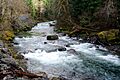
The beautiful Sol Duc River flowing through the county.
-
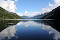
Lake Crescent in the spring, a popular spot for visitors.
-
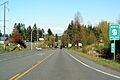
US Route 101 at an interchange in Clallam County.


See also
 In Spanish: Condado de Clallam para niños
