Sol Duc River facts for kids
Quick facts for kids Sol Duc River |
|
|---|---|

Sol Duc River
|
|
|
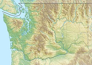
Location of the mouth of the Sol Duc River in Washington
|
|
| Country | United States |
| State | Washington |
| County | Clallam |
| Physical characteristics | |
| Main source | Olympic Mountains 47°55′30″N 123°41′59″W / 47.92500°N 123.69972°W |
| River mouth | Quillayute River 47°54′50″N 124°32′31″W / 47.91389°N 124.54194°W |
| Length | 78 mi (126 km) |
| Basin features | |
| Basin size | 219 sq mi (570 km2) |
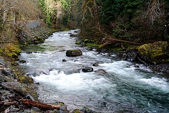
The Sol Duc River is a beautiful river in Washington, USA. It's about 78 miles (126 km) long. This river flows west through the northwest part of the Olympic Peninsula. It starts in the Olympic Mountains, within Olympic National Park and Olympic National Forest.
The Sol Duc River then flows through the wide Sol Duc Valley. Close to the Pacific Ocean, it joins the Bogachiel River. Together, they form the Quillayute River. This shorter river flows about 4 miles (6 km) to the Pacific Ocean at La Push.
Even though the Quillayute River is short, its many branches are important. The Sol Duc, Bogachiel, Calawah, and Dickey Rivers drain a huge area. This area, called a watershed, is the largest on the northern Olympic Peninsula. The Sol Duc River's watershed is the biggest of all the Quillayute's branches.
The main branches of the Sol Duc River are its North Fork and South Fork. Other important streams that flow into it include Bear Creek, Beaver Creek, and Lake Creek. Much of the land around the Sol Duc River is covered in valuable forests. Most of these forests have been logged at least once. However, the forests inside Olympic National Park are protected.
U.S. Route 101 follows the Sol Duc River for many miles. It goes through Olympic National Forest and the Sol Duc Valley. This road leads to the town of Forks. The town is named "Forks" because the Sol Duc, Bogachiel, and Calawah rivers meet nearby.
Contents
What's in a Name?
There are two common ways to spell the river's name: Sol Duc and Soleduck. Before 1992, "Soleduck" was the official spelling. But in 1992, the State of Washington changed it to "Sol Duc".
The name comes from the Quileute people. Their word for it, /só:liɬt'aqʷ/, means "sparkling waters."
Where Does the Sol Duc River Flow?
The Sol Duc River begins high up in the northern Olympic Mountains. It starts in Olympic National Park, on the north side of a ridge called High Divide. This ridge separates the Sol Duc and Hoh River areas. Bogachiel Peak is part of this High Divide. The Bogachiel River starts near Bogachiel Peak and flows south of the Sol Duc River. These two rivers eventually meet to form the Quillayute River.
The Sol Duc River generally flows west and northwest. Many smaller streams join it as it starts its journey.
- Bridge Creek flows from Heart Lake and joins the Sol Duc in Soleduck Flats.
- Rocky Creek comes from Mount Appleton and joins from the north.
- Seven Lakes Creek flows from the Seven Lakes Basin and joins from the south.
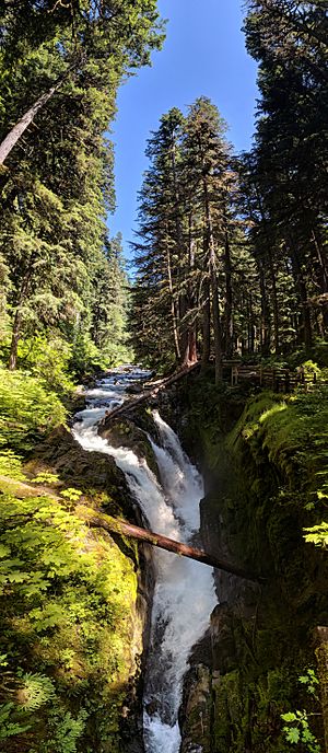
The river then plunges over the beautiful Sol Duc Falls. After the falls, Canyon Creek joins from the south. The Sol Duc River then turns more to the northwest, and its valley gets wider.
It passes by Sol Duc Hot Springs, a resort built in 1912. This resort was updated in the 1980s by the National Park Service. Nearby, you'll find the Sol Duc Campground and the Soleduck Ranger Station. After this, the valley becomes much wider. The Sol Duc River continues northwest, with the Sol Duc Road running alongside it. This road leads to the campground.
For a short distance, the edge of Olympic National Park runs along the river. Just before the river leaves the park, its two main branches join it. First, the North Fork Sol Duc River, then the South Fork Sol Duc River. Goodman Creek joins about a mile (1.6 km) below where the South Fork meets the main river.
After leaving Olympic National Park, the Sol Duc River flows west. It goes through part of Olympic National Forest. Its valley, known as the Sol Duc Valley, widens to about a mile (1.6 km) across. This valley is about 35 miles (56 km) long and keeps getting wider as the river flows west and southwest. U.S. Route 101 runs through most of this valley. Many smaller streams flow into the river from the mountains to the north and south.
- Kugel Creek joins the river near the Forest Service's Klahowya Campground.
- A few miles west, the river leaves Olympic National Forest.
- Bear Creek joins from the north near Bear Creek Campground.
- Beaver Creek joins from the north near Sappho. After this, the Sol Duc River starts to turn more southwest and south.
The Soleduck Salmon Hatchery is located along the river. It's near Lake Pleasant and the community of Beaver. Lake Creek, which flows from Lake Pleasant, joins the Sol Duc near Shuwah.
For several miles, the Sol Duc River flows very close to the Calawah River. The Calawah River is a branch of the Bogachiel River. U.S. Route 101 leaves the Sol Duc Valley here, turning south toward Forks. Washington State Route 110, also called La Push Road, continues down the Sol Duc Valley. After many turns, the Sol Duc River ends where it meets the Bogachiel River. The combined rivers are called the Quillayute River. This river flows west for several miles and empties into the Pacific Ocean near La Push.
North Fork Sol Duc River
The North Fork Sol Duc River starts on the west side of Mount Appleton. It flows mostly northwest. It joins the main Sol Duc River near Fairholm. This is about 4 miles (6.4 km) southeast of Mount Muller. This fork is about 13.5 miles (21.7 km) long and is entirely within Olympic National Park.
South Fork Sol Duc River
The South Fork Sol Duc River begins on the west side of Pine Mountain. It flows north. It joins the main Sol Duc River about 2.8 miles (4.5 km) southwest of Fairholm. This is also about 4 miles (6.4 km) south of Mount Muller. This fork is about 7.7 miles (12.4 km) long. Tom Creek joins it less than a mile (1.6 km) before it meets the main Sol Duc River. The South Fork is entirely within Olympic National Forest.
River History
In the early 1900s, many settlers came to the northwest Olympic Peninsula. They wanted to cut down trees for timber. They bought land all over the Sol Duc watershed, especially in the easy-to-reach Sol Duc Valley.
In January 1921, a huge storm called a "blowdown" knocked down trees. This happened over a large area between the Sol Duc and Hoh Rivers. At least 1,700 trees fell in the Sol Duc Valley. This was along the road between Sappho and Lake Crescent. Many settlers who had bought timberland to sell found their land was now worthless. Many of them simply moved away.
Large wildfires also burned through the forests. This happened in the upper Sol Duc Valley in 1907 and again in 1951. Fires in this area often spread quickly from east to west. But they stay narrow from north to south. This is because of the wind patterns near Lake Crescent. East winds speed up as they are pushed through a narrow valley west of Lake Crescent. Then they go into the Sol Duc Valley.
The 1951 fire started on September 20. It had not rained for 108 days before that. Strong winds pushed the fire west down the Sol Duc Valley. It moved about 18 miles (29 km) in just 6 hours. Over 30,000 acres (121 km²) of trees were destroyed. The smoke in the city of Forks was so thick that drivers could barely see the road. This was even in the middle of the day. The fire reached the edge of Forks. It destroyed 28 houses and many other buildings. Then, a light rain began to fall, which stopped the fire.
Amazing Fish in the Sol Duc River
The Sol Duc River and the other branches of the Quillayute River are home to many healthy fish. They have some of the best wild winter steelhead populations in the Pacific Northwest. In some years, as many as 19,000 steelhead return to lay their eggs. There are also many chinook and coho salmon.
The river's fish habitats stay healthy because there are no glaciers at the start of the streams. The Sol Duc River is special among the Quillayute's branches. It has a wide variety of fish that travel to spawn, and they are very healthy. It is the only Quillayute branch that has spring chinook salmon. It also has sockeye salmon in June and July. And it has "summer" coho salmon in August and September. Coastal cutthroat trout also lay their eggs in the Sol Duc River.
The Sol Duc River is one of the few rivers on the Olympic Peninsula that has all five main types of salmon. The upper part of the Sol Duc is a top place for coho salmon to lay their eggs.
Sol Duc River's Tributaries
Here are some of the streams that flow into the Sol Duc River, listed from its start to its end. "Left" and "right" show which side the stream joins from, as you look downstream.
- Blackwood Creek (left)
- Munden Creek (left)
- Alkee Creek (left)
- South Fork Sol Duc River (left)
- Tom Creek (left)
- North Fork Sol Duc River (right)
- Goodman Creek (left)
- Camp Creek (left)
- Kugel Creek (left)
- Bear Creek (right)
- Beaver Creek (right)
- Bockman Creek (left)
- Lake Creek (right)
- Shuwah Creek (left)
- Maxfield Creek (left)
- Tassel Creek (left)
- Sanderson Creek (right)
 | Lonnie Johnson |
 | Granville Woods |
 | Lewis Howard Latimer |
 | James West |


