Hoh River facts for kids
Quick facts for kids Hoh River |
|
|---|---|
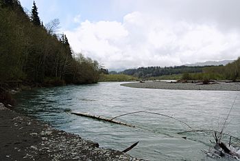
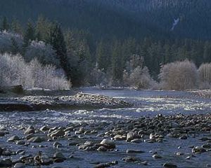
The Hoh river in spring
|
|
|
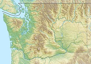
Location of the mouth of the Hoh River in Washington
|
|
| Country | United States |
| State | Washington |
| Counties | Clallam, Jefferson |
| Physical characteristics | |
| Main source | Hoh Glacier Mount Olympus, Olympic Mountains, Washington 7,000 ft (2,100 m) 47°48′37″N 123°38′55″W / 47.81028°N 123.64861°W |
| River mouth | Pacific Ocean 47°44′58″N 124°26′21″W / 47.74944°N 124.43917°W |
| Length | 56 mi (90 km) |
| Basin features | |
| Basin size | 299 sq mi (770 km2) |
The Hoh River is a cool river located on the Olympic Peninsula in Washington State, USA. It's about 56 miles (90 km) long. The river starts high up at the Hoh Glacier on Mount Olympus. From there, it flows west through the amazing Olympic Mountains and Olympic National Park. Finally, it empties into the Pacific Ocean near the Hoh Indian Reservation.
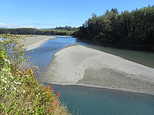
The Hoh River gets its water from glaciers on Mount Olympus, like the Blue Glacier. These glaciers grind rocks into a fine powder called "glacial flour." This powder makes the Hoh River look a milky, slate blue color. The river valley is wide and flat. This allows the glacial powder to settle, creating many gravel bars and side channels. This makes the Hoh a "braided river," meaning it splits into many smaller streams that rejoin.
The river's name comes from the Quinault placename /húxw/. This name is also used for the Hoh tribe.
Contents
Journey of the Hoh River
The Hoh River begins as meltwater from the Hoh Glacier on Mount Olympus. It flows north, then west, curving around the mountain. Along its journey, it collects water from other glaciers and streams. Some of these include the Ice River and Glacier Creek.
As the river flows downstream, its valley gets wider. It starts to look "braided" with many small channels. Several creeks join the Hoh River, like Falls Creek and Slate Creek.
The National Park Service has a cabin called Olympus Ranger Station along the river. Further down, you'll find the Happy Four backcountry camping area. The Hoh Rain Forest Visitor Center is also located near the river. This center is the starting point for the Hoh River Trail. This trail follows the river into Olympic National Park.
The Hoh River continues flowing west, and a major branch, the South Fork Hoh River, joins it. After this, the Hoh River leaves Olympic National Park. It flows through a wider valley with low mountains. You'll find ranches and private lands here. Many smaller creeks, like Owl Creek and Maple Creek, add to the river's flow.
Near the end of its journey, the Hoh River makes a big horseshoe bend. U.S. Highway 101 crosses the river here. The river then flows through a wide, flat area before reaching the Pacific Ocean. For its last two miles, the Hoh River forms the border between the Hoh Indian Reservation and Olympic National Park.
The South Fork Hoh River
The South Fork Hoh River also starts from glaciers on Mount Olympus. It flows west through Olympic National Park. This part of the river also becomes braided in a wide, U-shaped valley. It eventually joins the main Hoh River. There's a campground on the South Fork for visitors.
History of the Hoh River Area
The original people of the Hoh River area are the Hoh tribe. They call themselves chalat and their name for the river is chalak'ac'it.
One of the first times Europeans met the Hoh people was in 1787. A British fur trader sent a boat up the Hoh River. There was a conflict, and the incident led to a nearby island being named Destruction Island. The Hoh people have a different story, saying they never harmed shipwrecked sailors.
Later, in 1808, a Russian ship called the Sv. Nikolai ran aground nearby. There was tension between the Russian crew and the local Hoh people. Some Russians were captured, and others fled up the Hoh River. They built a small fort but eventually surrendered to the Hoh tribe. The captured Russians were later returned to their company.
In the 1850s, Isaac Stevens, the first governor of Washington Territory, tried to make treaties with the tribes of the Olympic Peninsula. The goal was for the tribes to give up their land. In 1855, a treaty was signed. The Hoh tribe, however, refused to move from their land. They said they only agreed to keep peace and allow trade. Because of their strong stand, in 1893, President Grover Cleveland created the Hoh Reservation for them. It is located on the south side of the Hoh River's mouth.
Early settlers in the Hoh River valley faced many challenges. The forest was very thick, and there were huge trees. Floods were common, and it was hard to get supplies or travel on the river. Even so, some people settled there. The area that is now Olympic National Park was never settled by non-Native people. Over time, the number of settlers decreased.
In 1911, a town called Oil City was started near the mouth of the Hoh River. People hoped to find a lot of oil there, but no large amounts were ever found. Today, much of that area is part of the Olympic Wilderness Park.
Nature and Wildlife
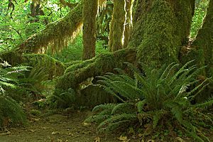
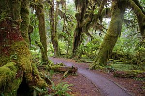
A big part of the Hoh River flows through the famous Hoh Rainforest. This is a special type of temperate rain forest, which is quite rare. It gets a lot of rain in winter, making everything super green. The trees, like giant Western Hemlocks and Sitka Spruces, are often covered in mosses and ferns. This forest is one of the best examples of a temperate rain forest in the United States. It's a very popular spot in Olympic National Park! When trees fall, they often become "nurse logs," helping new plants grow.
When Olympic National Park was created in 1938, one of its main goals was to protect the large herds of Roosevelt elk. Today, about 400 of the park's 4,000–5,000 elk live in the Hoh River valley.
The Hoh River is also home to many types of salmon and steelhead fish. These include spring and fall chinook, coho salmon, and winter and summer steelhead. There are also smaller numbers of chum and sockeye salmon. The Hoh tribe works with the Washington Department of Fish and Wildlife to manage these fish.
Who Manages the Land?
The land around the Hoh River is managed by different groups:
- About 57.6% is managed by the National Park Service.
- About 24.4% is managed by Washington State.
- About 17.6% is private land.
- Small parts are managed by the National Forest and the Hoh Indian Reservation.
Fun Activities and Recreation
The Hoh River is a great place for outdoor adventures!
Hoh River Trail
The Hoh River Trail is managed by the National Park Service. It starts at the Hoh Rain Forest Visitor Center. The trail follows the Hoh River east, deep into the park. After about 17.5 mi (28.2 km), it reaches Glacier Meadows near Mount Olympus.
The trail starts at about 600 ft (180 m) high and is mostly flat for the first 13 mi (21 km). After that, it climbs steeply to Glacier Meadows, which is about 4,300 ft (1,300 m) high. You'll hike through the lush Hoh Rain Forest and then into mountain forests and high meadows. There are many campsites along the trail if you want to stay overnight. People who want to climb Mount Olympus often use this trail to reach the mountain. Climbing Mount Olympus requires special skills for glaciers.
Other Trails
- The Hoh Lake Trail branches off from the Hoh River Trail. It goes up to Hoh Lake and Bogachiel Peak. From there, it crosses a high ridge into the Sol Duc River valley.
- The Oil City Trail is also managed by Olympic National Park. It starts on the north side of the Hoh River's mouth and goes about a mile to the Pacific coast. From there, you can hike north along the coast.
 | William L. Dawson |
 | W. E. B. Du Bois |
 | Harry Belafonte |


