
Bogachiel Peak facts for kids
Quick facts for kids Bogachiel Peak |
|
|---|---|

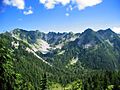
Bogachiel Peak, northwest aspect
|
|
| Highest point | |
| Elevation | 5,478 ft (1,670 m) NAVD 88 |
| Prominence | 524 ft (160 m) |
| Geography | |

Bogachiel Peak
Location in Washington (state)

Bogachiel Peak
Location in the United States
|
|
| Location | Clallam County, Washington, U.S. |
| Parent range | Olympic Mountains |
| Topo map | USGS Bogachiel Peak |
| Geology | |
| Age of rock | Eocene |
| Climbing | |
| Easiest route | Hiking Trail |
Bogachiel Peak is a mountain that stands 5,478-foot (1,670 m) tall. It is part of the Olympic Mountains in Washington, U.S. This peak is found inside the beautiful Olympic National Park.
It is a very high point on an area called the High Divide. It also marks the southern end of the Seven Lakes Basin. The mountain is located where the Bogachiel River begins.
The name "Bogachiel" comes from the Quileute language. It means "muddy waters" or "gets cloudy after a rain." This describes how the river can look after a storm.
Contents
Understanding the Climate Around Bogachiel Peak
The area around Bogachiel Peak has a special type of weather. It is called a marine west coast climate. This means it gets a lot of rain, especially in winter.
How Weather Forms Here
Most of the weather in this region starts over the Pacific Ocean. These weather systems then move towards the Olympic Mountains. When they hit the tall peaks, the air is forced to rise.
As the air goes up, it cools down. This causes the moisture in the air to turn into rain or snow. This process is called Orographic lift. It's why the Olympic Mountains get so much precipitation.
Seasonal Weather Patterns
During the winter, the weather is often cloudy and wet. But in the summer, things change. High pressure systems over the Pacific Ocean become stronger. This often brings clear skies and less rain.
The water from the rain and melting snow flows off the mountain. It drains into several rivers. These include the Bogachiel River, Sol Duc River, and the Hoh River.
Images for kids
-
West aspect

