Bogachiel River facts for kids
Quick facts for kids Bogachiel River |
|
|---|---|

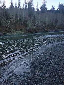
Bogachiel River, near Forks, Washington
|
|
|
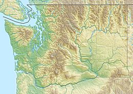
Location of the mouth of the Bogachiel River in Washington
|
|
| Country | United States |
| State | Washington |
| Counties | Clallam, Jefferson |
| City | Forks |
| Physical characteristics | |
| Main source | Bogachiel Peak Olympic Range 3,960 ft (1,210 m) 47°54′19″N 123°46′56″W / 47.90528°N 123.78222°W |
| River mouth | Quillayute River 35 ft (11 m) 47°54′50″N 124°23′31″W / 47.91389°N 124.39194°W |
| Length | 50 mi (80 km) |
| Basin features | |
| Tributaries |
|
The Bogachiel River is a cool river located on the Olympic Peninsula in Washington. It starts high up near Bogachiel Peak and flows west through the amazing Olympic National Park. After leaving the park, it joins the Sol Duc River. Together, they form the Quillayute River, which then flows into the Pacific Ocean near La Push, Washington.
The Quillayute River system is very important. It includes the Bogachiel, Sol Duc, Calawah, and Dickey Rivers. This system drains the largest watershed on the northern Olympic Peninsula. A watershed is an area of land where all the water drains into a single river or lake.
The name "Bogachiel" comes from the Quileute language. The Quileute people are a Native American tribe from this area. The name means "gets muddy after a rain" or "muddy waters." This makes sense because the river can get quite cloudy after heavy rainfall.
Where the River Flows
The Bogachiel River begins with many small streams near Bogachiel Peak. This area is deep inside the Olympic Wilderness. It's in the northwest part of the Olympic Peninsula. The river flows west through a deep valley. It collects water from many mountain streams. One important stream it meets is the North Fork Bogachiel River.
After joining the North Fork, the Bogachiel River flows along the border between Clallam County and Jefferson County. It crosses this line many times. The river picks up more water from streams like Tunwata Creek and Hades Creek. Then, it leaves Olympic National Park.
The river then flows along the edge of the Olympic National Forest. It turns northwest and goes through Bogachiel State Park. U.S. Highway 101 follows the river for several miles. Just west of the city of Forks, the Calawah River joins the Bogachiel. The city of Forks is named because it sits between these two rivers, where they "fork."
Below where the Calawah River joins, the Bogachiel River gets much wider. It flows slowly westward through a wide valley. The Sol Duc River comes from the north and flows next to the Bogachiel for a few miles. Finally, they join to form the Quillayute River. The Quillayute River flows west for only about six more miles before reaching the Pacific Ocean at La Push. The mouth of the Quillayute River is part of the Quileute Indian Reservation.
Nature and Wildlife
The upper Bogachiel River valley is home to amazing temperate rain forests. These forests are similar to the famous Hoh Rain Forest in the Hoh River valley. Temperate rainforests get a lot of rain and have huge, ancient trees.
Fun Things to Do
A big part of the Bogachiel River is inside the wilderness of Olympic National Park. There's a trail called the Bogachiel Trail. It starts a few miles outside the park. This trail follows the Bogachiel River and then the North Fork Bogachiel. It goes up into the high mountains. From there, you can connect to other trails that lead to the Sol Duc River valley or the Hoh River valley. It's a great place for hiking and exploring nature!
The Bogachiel River is also very popular for fishing. It's known for its healthy populations of wild winter steelhead. Steelhead are a type of rainbow trout that live in the ocean but return to freshwater rivers to lay their eggs. Sometimes, as many as 19,000 wild steelhead return to the river. There are also many hatchery-raised steelhead, sometimes up to 50,000!
The river also has large numbers of Chinook and coho salmon. You can also find coastal cutthroat trout and Dolly Varden living in the river all year round.
Unlike many other big rivers on the Olympic Peninsula, the Bogachiel River's source is not from glaciers. This means it doesn't get big floods in spring and summer from melting ice. It also doesn't carry as much mud and dirt. This makes the Bogachiel River a great place for fishing for a longer part of the year!
 | Valerie Thomas |
 | Frederick McKinley Jones |
 | George Edward Alcorn Jr. |
 | Thomas Mensah |


