
Dickey River facts for kids
Quick facts for kids Dickey River |
|
|---|---|

Where the Dickey River meets the Quillayute River, seen from the bridge at Mora Road near Rialto Beach
|
|

Location of the mouth of the Dickey River in Washington
|
|
| Country | United States |
| State | Washington |
| County | Clallam |
| Physical characteristics | |
| Main source | Confluence of West and East Forks Olympic Mountains 47°59′6″N 124°32′59″W / 47.98500°N 124.54972°W |
| River mouth | Quillayute River 4 ft (1.2 m) 47°55′16″N 124°37′24″W / 47.92111°N 124.62333°W |
The Dickey River is a cool stream located on the Olympic Peninsula in the state of Washington, United States. This river is special because it's made up of three main parts, or "forks." These are called the East Fork, West Fork, and Middle Fork Dickey Rivers.
The main part of the river starts when the East and West Forks join together. The river and its forks begin in the northwestern part of the Olympic Peninsula. They then flow generally south and west. Finally, they meet the Quillayute River very close to where it flows into the Pacific Ocean.
Contents
What's in a Name?
The name "Dickey River" comes from the Quileute people. They are a Native American tribe from this area. The original Quileute term was dichoh dock-teacer or de tho date t doh.
This name was used for both the river and a group of the tribe who lived along its banks. It meant "people who live on the first branch of the Quillayute River." It could also mean "people who live on the dark water."
Meet the Forks of the River
The Dickey River has three main branches, or forks, that come together to form the main stream. Each fork has its own journey.
East Fork Dickey River
The East Fork Dickey River is about 16 miles (26 km) long. It starts in the northwestern part of the Olympic Peninsula. As it flows south, it collects water from smaller streams. These include Skunk Creek and Thunder Creek. Eventually, it meets the West Fork to create the main Dickey River.
West Fork Dickey River
The West Fork Dickey River is a bit longer, stretching just over 20 miles (32 km). This fork begins as the water flowing out of Dickey Lake. Many smaller streams, like Stampedge Creek, Ponds Creek, and Sands Creek, feed into Dickey Lake.
The West Fork flows out of the south end of Dickey Lake. Soon after, it is joined by the Middle Fork Dickey River. A little further downstream, the West Fork meets the East Fork. This is where the main Dickey River officially begins.
Middle Fork Dickey River
The Middle Fork Dickey River starts slightly east of Dickey Lake. It flows generally south. Its journey ends when it joins the West Fork Dickey River.
The Main Dickey River
The main part of the Dickey River starts where the East and West Forks combine. From this point, it flows south for about 7 miles (11 km). Along its path, it gathers water from other small streams like Larger Creek, Cotby Creek, and Coat Creek.
The river also flows past the Quillayute State Airport. The Dickey River finally empties into the Quillayute River. This meeting point is about a mile north of La Push. The area where the Dickey and Quillayute Rivers meet is part of the beautiful Olympic National Park.
Images for kids
-
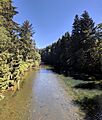
Looking upriver from the bridge at Mora Road
-
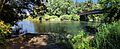
A wide view of the final part of the Dickey River, from the boat ramp. This is between the Mora Road bridge and where it meets the Quillayute River.

