Lake Crescent facts for kids
Quick facts for kids Lake Crescent |
|
|---|---|
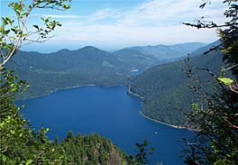
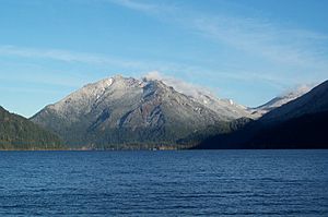
View of the ancient landslide that dammed Lake Crescent
|
|
| Location | Clallam County, Washington |
| Coordinates | 48°04′N 123°50′W / 48.06°N 123.83°W |
| Type | Crescent |
| Primary inflows | Barnes Creek, Smith Creek, Aurora Creek, Eagle Creek |
| Primary outflows | Lyre River |
| Basin countries | United States |
| Max. length | 12 mi (19 km) |
| Surface area | 5,127-acre (21 km2) |
| Average depth | 300 ft (91 m) |
| Max. depth | 624 ft (190 m) officially; over 1,000 ft (300 m) unofficially |
| Surface elevation | 580 ft (180 m) |
| Settlements | Piedmont |
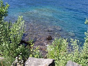
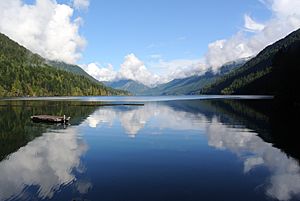
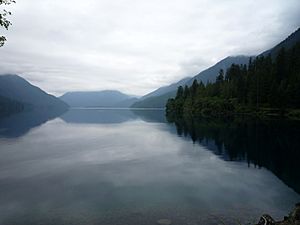
Lake Crescent is a very deep lake found inside Olympic National Park in Clallam County, Washington, United States. It is about 17 miles (27 km) west of Port Angeles, Washington. The lake is known for its amazing blue water and how clear it is.
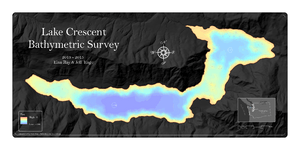
Lake Crescent is officially the second deepest lake in Washington. Its official maximum depth is 624 feet (190 m). For many years, people thought it was over 1,000 feet (300 m) deep. However, a detailed survey done in 2013 and 2014 showed the deepest spot is actually 596 feet (182 m). This survey also found that the lake holds about 0.5 cubic miles of fresh water.
The lake's clear blue water is due to a lack of nitrogen. Nitrogen helps algae grow, so without much of it, the water stays very clear. Lake Crescent is a popular spot for fun activities. There are many trails nearby, like the Spruce Railroad Trail and the Barnes Creek trail to Marymere Falls. The Spruce Railroad Trail follows an old logging railroad path. Along this trail, you can find an old railroad tunnel and "Devils Punch Bowl," which is a great place for swimming.
Contents
How Lake Crescent Was Formed
Lake Crescent was created a long, long time ago. Giant glaciers moved through the area during the last Ice Age. As they moved, these glaciers carved out deep valleys. At first, the water from the Lake Crescent valley flowed into the Indian Creek valley and then into the Elwha River. Fish like steelhead and coastal cutthroat trout could swim into the valley from other waters.
About 8,000 years ago, a huge landslide happened. It came from one of the Olympic Mountains. This landslide blocked Indian Creek, and the deep valley slowly filled with water. Many geologists think that Lake Crescent and nearby Lake Sutherland formed at the same time. The landslide then separated them.
There is also a Klallum tribe legend about how the lake formed. It says that Mount Storm King was angry with fighting tribes. So, the mountain threw a huge boulder. This boulder cut Lake Sutherland in two, creating Lake Crescent. You can still see the results of this ancient landslide from the top of Pyramid Mountain. Eventually, the water found a new way out of the valley. It spilled into the Lyre River, flowed over the Lyre River Falls, and then went out to the Strait of Juan de Fuca.
Unique Fish in Lake Crescent
When the landslide happened, it blocked the way for fish to swim in and out of the lake. Fish that used to swim from the ocean to lay eggs (called anadromous fish) became "landlocked." This means they were trapped in the lake. They could not swim up the Lyre River Falls.
Over a long time, two special kinds of fish developed only in Lake Crescent. These are called endemic fish. One is the Beardslee trout, which is related to the rainbow trout. It lays its eggs in the Lyre River above the falls. The other is the Crescenti Cutthroat Trout. This fish lays its eggs in Barnes Creek.
Understanding the Lake's Depth
For many years, people wondered exactly how deep Lake Crescent was. In the early 1960s, the U.S. Navy tried to measure the depth using a Furuno depth sounder. Their equipment could not find the very bottom.
Later, in 1970, students from Peninsula College in Port Angeles, Washington did their own survey. Their tools could not measure beyond 624 feet (190 m). So, this became the "official" depth recorded by the National Park Service. However, in the 1980s, when a power cable was being put into the lake, instruments showed depths over 1,000 feet (300 m). This was the maximum depth their equipment could show.
To get a more accurate measurement, two scientists, Eian Ray and Jeff Enge, did a full survey of the lake in 2013 and 2014. They took over 5,000 depth measurements! Their study showed that the deepest spot in Lake Crescent is 596 feet (182 m). They also found that much of the lake's shoreline drops down very steeply, like an underwater cliff. The scientists believe that the very deep readings from the 1980s might have been wrong. They think the sonar signals might have bounced off these steep underwater cliffs, making it seem deeper than it was.
How Lake Crescent Got Its Name
It's not completely clear how Lake Crescent got its name. It might be because of its curved, crescent shape. Or, it might be named after nearby Crescent Bay, which was named by Henry Kellett in 1846.
In 1849, two fur trappers from Britain and Canada, John Sutherland and John Everett, explored inland from Crescent Bay. They found two lakes. These lakes became known as Lake Sutherland and Everett Lake. Later, Everett Lake was renamed Lake Crescent. The lake was also known by other names, like Big Lake and Elk Lake, for a while.
In 1890, a company called the Port Crescent Improvement Company was trying to promote a town near the lake. M.J. Carrigan started a newspaper called the Port Crescent Leader to help the town grow. He wrote about the beautiful lake and called it Lake Crescent. After that, the name became very popular and stuck.
See also
 In Spanish: Lago Crescent para niños
 | Chris Smalls |
 | Fred Hampton |
 | Ralph Abernathy |


