
Mount Storm King facts for kids
Quick facts for kids Mount Storm King |
|
|---|---|
 |
|
| Highest point | |
| Elevation | 4,500+ ft (1,370+ m) NGVD 29 |
| Prominence | 750 ft (230 m) |
| Geography | |

Mount Storm King
Location in Washington (state)
|
|
| Parent range | Olympic Mountains |
| Topo map | USGS Lake Sutherland |
| Climbing | |
| Easiest route | Mount Storm King trail, class 3 |
Mount Storm King is a tall mountain found inside Olympic National Park. It is about 20 miles west of Port Angeles, in Washington. This mountain stands on the south side of Lake Crescent, close to a spot called Barnes Point. Mount Storm King reaches a height of 4,500 feet (about 1,370 meters) above sea level.
Contents
Exploring Mount Storm King
Mount Storm King is a popular spot for hikers and adventurers. The trail to the top offers amazing views. It is known for being a challenging but rewarding climb.
How to Hike the Trail
The path to the summit of Mount Storm King begins near the Storm King Ranger Station. At first, you will follow the same trail that leads to Marymere Falls. After a short distance, the trail splits off to the north.
The first 1.9 miles (about 3 kilometers) of the trail are well-maintained. This part is usually easy to walk on. However, the rest of the climb becomes much more difficult.
The Challenging Climb
To reach the very top, hikers need to do some scrambling. This means using both your hands and feet to climb over rocks. The rocks can be loose, so you need to be careful. There are also parts of the trail with exposure. This means you will be walking on narrow paths with steep drop-offs nearby. It is important to be cautious and aware of your surroundings.

The Legend of Mount Storm King
Local stories from the Klallam tribe tell a fascinating tale about how Mount Storm King and nearby lakes were formed.
A Mountain's Anger
According to the legend, Mount Storm King became very angry. There were tribes fighting at the base of the mountain. To stop the fighting, the mountain broke off a huge boulder from its peak. It then threw the boulder at the warriors.
Creating the Lakes
The giant boulder killed the warriors. It also split a land feature called Tsulh-mut into two pieces. This powerful event created two beautiful lakes: Lake Crescent and Lake Sutherland. This legend helps explain the unique landscape of the area.
Images for kids
-
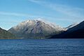
Mount Storm King in February 2002.
