Ozette Lake facts for kids
Quick facts for kids Ozette Lake |
|
|---|---|

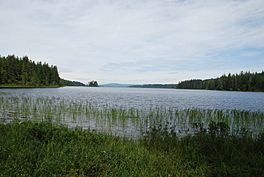
Ozette Lake in 2008.
|
|
| Location | Clallam County, Washington, United States |
| Coordinates | 48°5′40.21″N 124°37′56.95″W / 48.0945028°N 124.6324861°W |
| Primary outflows | Ozette River |
| Basin countries | United States |
| Surface area | 7,787 acres (3,151 ha) |
| Max. depth | 331 ft (101 m) |
| Surface elevation | 29 ft (8.8 m) |
| Islands | 3 (Tivoli, Garden Island, Baby Island) |
Ozette Lake is a large, natural lake in Washington state. It's special because it's still very wild and untouched. The lake covers about 29.5 km2 (11.4 sq mi).
The Makah people, who are Native Americans, called this lake Kahouk. This name means "large lake." Ozette Lake is about 8 mi (13 km) long and 3 mi (4.8 km) wide. It is found within the northern part of the Olympic National Park's coastal area. The lake sits 29 ft (8.8 m) above sea level. The Ozette River flows out of its northern end. The village of Ozette, Washington is also located at the north end of the lake. It is a very deep lake, reaching 331 feet (101 metres) down. This means its bottom is more than 300 feet (91 metres) below sea level.
Contents
Islands of Ozette Lake
Ozette Lake has three islands. Their names are Tivoli, Garden Island, and Baby Island. Tivoli Island has a sandy beach. It is a popular spot for people who like to kayak or canoe. Campers can stay overnight in tents there. However, it is a long trip to get to the island.
Erickson's Bay campground is the only campground in Olympic National Park that you can only reach by boat.
Exploring the Trails
Ozette Lake has several trails that lead to the Pacific Coast Marine Sanctuary. Three of these trails are made of cedar boardwalks. The Olympic National Park Service takes care of these boardwalks.
The two most popular trails start from the park's information kiosks and restrooms. These are located at the north end of Ozette Lake.
Northern and Southern Boardwalk Trails
The northern trail is a cedar boardwalk. It leads to Cape Alava. This trail goes through Ahlstrom's Prairie. The southern boardwalk trail goes to Sand Point. Here, you can see the Ozette Indian Petroglyphs at Wedding Rock. There are 54 ancient carvings found there.
Other Trails
There is a shorter trail that is about 2.5 mi (4.0 km) long. You can only reach this trail by boat. It goes out to the wild ocean beaches from Erickson's Bay. This bay is on the northwestern side of Ozette Lake.
Another longer hiking option is the Ozette Loop. This trail connects the Sand Point and Cape Alava trails. You can hike up or down the beach to get from one trail head to the other. This loop is about 9 mi (14 km) long.
Two other trails include the Coast Guard Trail. This trail leads to the beach just south of the Park-maintained trail from Erickson's Bay. There is also a trail from Allen's Bay that goes out to Kayostla Beach. Both of these trails are not developed. They are often very muddy.
Camping at Ozette Lake
The National Park Service manages a main campground. It is located at the north end of Ozette Lake. This campground has 15 different sites for campers.
See also
 In Spanish: Lago Ozette para niños
 | Tommie Smith |
 | Simone Manuel |
 | Shani Davis |
 | Simone Biles |
 | Alice Coachman |


