Georgia Depression facts for kids
Quick facts for kids Georgia Depression |
|
|---|---|

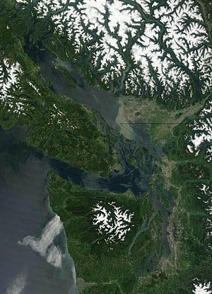
The coastal lowlands surrounding the Salish Sea make up most of the Georgia Depression
|
|

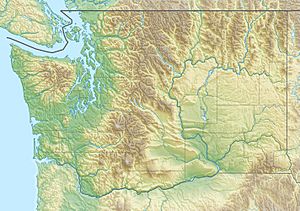
Topographic map of Washington showing the Georgia Depression in the northwestern corner of the state
|
|
| Location | British Columbia, Canada Washington, United States |
| Part of | North American Cordillera |
| Geology | Depression |
The Georgia Depression is a large, low-lying area in the Pacific Northwest of western North America. It includes the flat lands of southwestern British Columbia and northwestern Washington. This area stretches along the shores of the Salish Sea.
Contents
How the Georgia Depression Formed
The Georgia Depression began to form about 150 million years ago. This happened when huge continental plates of the Earth's crust slowly crashed into each other. At first, it was a wide valley. Many rivers flowed through this valley to reach the Pacific Ocean. The mouth of the Strait of Juan de Fuca is where these rivers would have met the ocean.
Much of what the land looks like today was shaped by a giant ice sheet. This ice sheet was called the Cordilleran Ice Sheet. It covered the area during the Vashon Glaciation, a very cold period from about 19,000 to 16,000 years ago. When the ice melted and moved away, it left behind a landscape with many marks. Sea water then filled these low areas, creating the Salish Sea.
Geography of the Georgia Depression
The Georgia Depression is surrounded by tall mountains. To the north are the Pacific Ranges. To the west, you'll find the Vancouver Island Ranges and the Olympic Mountains. The North Cascades are to the east.
This depression includes several important areas. These are the Fraser Lowland, the Nanaimo and Nahwitti lowlands on Vancouver Island, and the Puget Sound basin. It also includes all the islands and waterways of the Salish Sea. Most people living in British Columbia and Washington make their homes in this low-lying region.
Geology of the Land
The land in the Georgia Depression has flat areas and rolling hills. These areas were carved by glaciers. The ground beneath is made of sedimentary rocks. Most of the soil here comes from materials left behind by glaciers. This includes glacial till (rock and dirt dropped by ice), glacial outwash (sediment carried by meltwater), and Lacustrine deposits (sediment settled in ancient lakes).
Ecology and Wildlife
Much of the Georgia Depression is dry and flat. It is also at a low elevation compared to the mountains around it. Because of this, many different kinds of plants and animals live here.
However, people have changed a lot of the natural environment. This has happened through things like factories, farming, cutting down trees (forestry), and building cities and towns.
See also
 In Spanish: Depresión de Georgia para niños
 | Kyle Baker |
 | Joseph Yoakum |
 | Laura Wheeler Waring |
 | Henry Ossawa Tanner |

