Puyallup River facts for kids
Quick facts for kids Puyallup River |
|
|---|---|

|
|

Map of the Puyallup River watershed
|
|
|
Location of the mouth of the Puyallup River in Washington
|
|
| Country | United States |
| State | Washington |
| Counties | Pierce |
| Cities | Orting, Puyallup, Tacoma |
| Physical characteristics | |
| Main source | Mount Rainier 2,280 ft (690 m) 46°51′50″N 121°57′4″W / 46.86389°N 121.95111°W |
| River mouth | Puget Sound Commencement Bay 0 ft (0 m) 47°16′10″N 122°25′42″W / 47.26944°N 122.42833°W |
| Length | 45 mi (72 km) |
| Basin features | |
| Basin size | 948 sq mi (2,460 km2) |
| Tributaries |
|
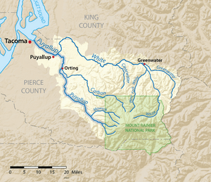
The Puyallup River ( pew-AL-əp) is a river in the state of Washington, United States. It is about 45 miles (72 km) long. This river starts from glaciers on the west side of Mount Rainier. It flows mostly northwest and ends in Commencement Bay, which is part of Puget Sound. The river and its smaller streams (tributaries) collect water from an area of about 948 square miles (2,455 km²) in Pierce and southern King Counties.
The area where the river collects its water, called its watershed, is the newest in the Puget Sound region. It was formed by a series of lahars (volcanic mudflows) that began around 5,600 years ago. Because of this, the 150,000 people living in the valley could be at risk from future lahars. To help keep people safe, the United States Geological Survey has set up a special warning system for lahars.
Contents
Journey of the Puyallup River
The Puyallup River actually starts as two separate streams. These are the North Puyallup River and the South Puyallup River. Both of them begin at glaciers on Mount Rainier. The North Puyallup River flows from the bottom of the Puyallup Glacier. The South Puyallup River comes from the Tahoma Glacier.
These two streams flow through the western part of Mount Rainier National Park. They join together just outside the park boundary. This is where the main Puyallup River officially begins.
River's Path and Tributaries
The main Puyallup River flows north and then northwest from Mount Rainier. The Mowich River is a smaller river that also starts from Mount Rainier's glaciers. It joins the Puyallup River from the east. After the Mowich River joins, the Puyallup River flows through a rough area of mountains and hills.
The river has a dam called the Electron Diversion Dam. This dam is located a short distance below where the Mowich River joins. The dam sends some of the Puyallup River's water into a long channel called a flume. This flume carries the water for several miles to a place called Electron. There, the water goes through machines called turbines in a hydroelectric power plant. These turbines use the water's power to make electricity. After that, the water flows back into the river. The Puyallup River flows through a very steep and narrow canyon between the Electron Dam and the power plant.
After Electron, the river turns north. It flows past the city of Orting. Here, the Carbon River joins it from the east. Like the Mowich, the Carbon River also starts from a glacier on Mount Rainier, which is called the Carbon Glacier. The Puyallup River keeps flowing north after Orting.
At Sumner, another glacier-fed river, the White River, joins the Puyallup. After the White River joins, the Puyallup River turns northwest. It flows past the cities of Puyallup and Fife. It also flows through the Puyallup Indian Reservation. Finally, it empties into Commencement Bay at the Port of Tacoma, which is part of the city of Tacoma.
River's Natural Features
The Puyallup River and its main smaller rivers begin in the glaciers of Mount Rainier. These glaciers constantly add sediment like silt and gravel to the rivers. This creates sand and gravel bars in the river. The thick layers of sediment in the riverbeds reduce how much water the river can hold. This causes the river to curve and flood when there is a lot of water flowing. It also makes the rivers become braided (like many small channels weaving together) and meandering (curving in loops).
During the summer, melting glacier water makes up most of the river's flow. This makes the Puyallup River look cloudy or muddy. Also, the glaciers cause the spring and summer runoff (water flowing over land) to start later than in river areas without glaciers.
Changes to the River's Environment
In the past, these natural factors led to frequent flooding. They also created many wetlands (areas of land covered by water) on the floodplain. This provided a rich and complex home for fish and other animals. The river's mouth at Commencement Bay used to be a large area of tidal flats and wetlands. This area was a river estuary delta.
However, human development and many flood control structures have greatly changed the Puyallup River. These structures include dams, levees (walls to prevent flooding), and culverts (pipes that carry water under roads). The estuary delta at the mouth of the Puyallup River has been almost completely replaced. It is now filled with the buildings and facilities of the Port of Tacoma. Less than 5% of the original estuary habitat is left.
Fish and Wildlife in the River
The Puyallup River is home to several types of salmon. A group of chinook salmon swim up the river in the fall. Coho, chum, and pink salmon are also found in the river. Other fish include steelhead, sea-run coastal cutthroat trout, and a protected species called bull trout. Sockeye salmon used to live in this river system. However, they are rarely seen there today.
How the River Has Been Changed

The Puyallup River and its main tributary, the White River, have been changed a lot since the 1900s. The Puyallup River between Sumner and its mouth at Tacoma was made straighter. In 1914, a dam was built at Game Farm Park. This dam was made to stop the White River from flowing into the Green River at Auburn. Since then, the White River has flowed into the Puyallup River instead.
Many structures to protect against floods were built along the rivers in the area. These include many levees. A large reservoir for storing floodwater, called Mud Mountain Lake, was created. This happened when the Mud Mountain Dam was built on the White River. As part of controlling floods, river channels and banks have been kept clear. This means removing things like gravel bars, large trees, and logjams.
These changes have greatly altered the natural look of the rivers. The rivers have generally become narrower. Now, water fills almost all the land between the river banks. In the past, the river had many braided channels and wetlands.
History of the Puyallup River
The river is named after the Puyallup tribe. This tribe lived throughout the river basin for a very long time. After the Treaty of Medicine Creek and the Puget Sound War, the Puyallup people were given a special area of land called a reservation. This reservation was located on the lower Puyallup River.
The Treaty of Medicine Creek also recognized the fishing rights of Native Americans on the Puyallup River. For many years, these rights were not respected. Then, in 1954, a man named Bob Satiacum was arrested for fishing on the river. His legal case went on for years. It eventually led to the 1974 Boldt Decision. This important decision gave half of all fishing rights in Washington state to Native American tribes.
The Puyallup tribe still owns and maintains several buildings and properties. These are located on their reservation lands near the mouth of the river. They are very involved in many decisions about the river. For example, they care about how much water is taken from the river at the Electron Diversion Dam.
The first known European to explore the Puyallup River valley was William Fraser Tolmie. In August 1833, he traveled to the Mount Rainier area. He went through the Puyallup and Mowich river valleys. Two Native American guides helped Tolmie on his journey. One was Lachalet, a Nisqually Indian. The other was Nuckalkat, a Puyallup.
 | Janet Taylor Pickett |
 | Synthia Saint James |
 | Howardena Pindell |
 | Faith Ringgold |


