Mowich River facts for kids
Quick facts for kids Mowich River |
|
|---|---|

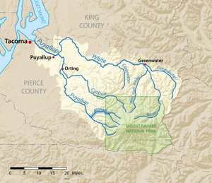
The Mowich River is shown highlighted on a map of the Puyallup River watershed
|
|
| Other name(s) | South Mowich River |
| Country | United States |
| State | Washington |
| County | Pierce |
| Physical characteristics | |
| Main source | Mount Rainier South Mowich Glacier 7,000 ft (2,100 m) 46°52′19″N 121°49′34″W / 46.87194°N 121.82611°W |
| River mouth | Puyallup River 1,680 ft (510 m) 46°54′2″N 122°1′49″W / 46.90056°N 122.03028°W |
| Length | 30 mi (48 km) |
| Basin features | |
| Tributaries |
|
The Mowich River is a river in the U.S. state of Washington. It's like a giant funnel for water, collecting rain and melted snow from the western side of Mount Rainier. This mountain is part of the Cascade Range.
The river actually starts with two main parts: the South Mowich River and the North Mowich River. The South Mowich is much bigger and is often seen as the main river. Water from several of Mount Rainier's glaciers flows into the Mowich River and its smaller streams. The top part of the river's area is inside Mount Rainier National Park. Finally, the Mowich River flows into the Puyallup River in the hills west of Mount Rainier.
The name "Mowich" comes from an old trading language called Chinook Jargon. In this language, "Mowich" means "deer." The name was first used for Mowich Lake, and then later for the river and a glacier.
Contents
The South Mowich River
The South Mowich River starts with streams that flow around a high area called Jeanette Heights. This part of the river is formed by melting ice from the South Mowich and Edmunds Glaciers. It then flows northwest for several miles. Many smaller streams, all fed by glaciers, join the South Mowich River. These two main branches meet just inside the western edge of Mount Rainier National Park.
There's another high, flat area called Sunset Park. It's located just southwest of the South Mowich River. A famous hiking path, the Wonderland Trail, goes through Sunset Park. It then goes down into the valley of the South Mowich River. Hikers cross the river right where the north and south branches meet. After that, the Wonderland Trail crosses the North Mowich River. It then climbs up to Mowich Lake and another high area called Spray Park.
The North Mowich River
The North Mowich River begins with streams that drain the North Mowich Glacier. This area is near a spot on Mount Rainier called Division Rook. Just below the end of the glacier, the river drops over a huge rock wall. This creates Moraine Falls, which is the first of two waterfalls on this river. Both waterfalls are very hard to reach on foot. Giant Falls is another waterfall located further downstream from Moraine Falls.
A ridge called Ptarmigan Ridge separates the North Mowich River's starting points from Spray Park. Much of Spray Park is drained by other streams that flow into the North Mowich River. Spray Creek starts in Spray Park and tumbles over Spray Falls. It then collects another stream called Grant Creek. Spray Creek flows down from Spray Park and along the bottom of a steep slope called Eagle Cliff. After this, it joins the North Mowich River.
Soon after Spray Creek joins, the North Mowich River is joined by Crater Creek. Crater Creek flows from Mowich Lake, which is a few miles to the north. Many smaller creeks, which drain Spray Park, flow into Crater Creek. The North and South Mowich Rivers then meet just downstream from this point.
The Main Mowich River Flow
After the North Mowich and South Mowich rivers join, they form what is called the Mowich River Proper. This main river flows west. It passes Paul Peak to the north, then leaves Mount Rainier National Park. Just outside the park, Meadow Creek joins the river. The Mowich River then flows past Martin Peak to the north. After that, it curves southwest and flows through a wide valley carved by glaciers. Rushingwater Creek joins the Mowich River just before the Mowich River itself flows into the Puyallup River.
Rivers and Streams that Join the Mowich
Here are the main streams that flow into the Mowich River and its branches:
South Mowich River Tributaries
- No major streams join this branch directly.
North Mowich River Tributaries
- Spray Creek
- Crater Creek
Main Mowich River Tributaries
- Meadow Creek
- Rushingwater Creek
River Geology
The Mowich River is formed by melting glaciers. This means it carries a lot of tiny bits of rock and dirt, like silt and gravel. After flowing down from the high slopes of Mount Rainier, the Mowich River moves through a wide valley. This valley was carved out by glaciers long ago. In this valley, thick layers of sediment (rock and dirt) build up in the riverbed. This creates sand and gravel bars, making the river split into many smaller channels that crisscross each other. This is called a braided river. The river also curves and winds, which is called meandering.
Just like other rivers that start high on Mount Rainier, the Mowich River valley is at risk from something called a lahar. A lahar is like a fast-moving mudslide made of volcanic ash, rock, and water. The Puyallup River, which the Mowich flows into, is also at risk from these powerful mudflows.
 | Georgia Louise Harris Brown |
 | Julian Abele |
 | Norma Merrick Sklarek |
 | William Sidney Pittman |

