
Carbon River facts for kids
Quick facts for kids Carbon River |
|
|---|---|

The Carbon River near the town of Carbanado. Looking upstream from Fairfax Bridge.
|
|

The Carbon River is shown highlighted in the Puyallup River watershed
|
|
| Country | United States |
| State | Washington |
| County | Pierce |
| City | Orting |
| Physical characteristics | |
| Main source | Mount Rainier Carbon Glacier 3,575 ft (1,090 m) 46°56′38″N 121°47′24″W / 46.94389°N 121.79000°W |
| River mouth | Puyallup River Orting 112 ft (34 m) 47°7′50″N 122°13′58″W / 47.13056°N 122.23278°W |
| Length | 30 mi (48 km) |
| Basin features | |
| Basin size | 78.9 sq mi (204 km2) |
| Tributaries |
|
The Carbon River is a river in Washington State. It starts at the Carbon Glacier on Mount Rainier. The river flows for about 30 miles (48 km). It then joins the Puyallup River near Orting.
Long ago, a man named Charles Wilkes called it the "Upthascap River". But in 1876, people found coal near the river. So, they renamed it "Carbon".
Contents
Where Does the Carbon River Flow?
The Carbon River begins at the Carbon Glacier. This glacier is on the north side of Mount Rainier. The river's upper part is inside Mount Rainier National Park. Small streams like Cataract Creek and Spukwush Creek feed into it.
The Carbon River quickly enters a wide valley. This valley was carved by glaciers. The river drops thick layers of sand and gravel here. This makes the river twist and turn. It also splits into many smaller channels. This is called a braided river.
After flowing past Mother Mountain and Chenuis Mountain, the river reaches Ipsut Creek. There is a campground there called Ipsut Creek campground. This was once the end of the Carbon River Road. But floods in 2006 washed parts of the road away.
Below Ipsut Creek, Chenuis Creek and Green Creek join the Carbon River. Soon after, the river leaves Mount Rainier National Park. Tolmie Creek also joins the river from the south.
The Carbon River flows northwest for a while. Then it turns west. It is joined by Evans Creek near the small town of Fairfax. From Fairfax to Carbonado, the river flows north through a narrow canyon.
After passing Carbonado, Lily Creek joins the river. The river valley then gets wider again. The Carbon River goes back to its braided and winding pattern. It flows west through a wide flat area. At Crocker, a main stream called South Prairie Creek joins it. Another big stream, Voight Creek, joins just below Crocker.
Below Crocker, the Carbon River flows northwest. It then joins the Puyallup River. The city of Orting is located where these two rivers meet.
How Was the Carbon River Formed?
The Carbon River is made from melting glacier ice. Because of this, it carries a lot of dirt and rocks. This includes tiny bits of silt and larger pieces of gravel.
When the river leaves the Carbon Glacier, it flows through a wide valley. This valley was carved out by glaciers. The river drops thick layers of sediment (dirt and rocks) in its bed. This creates sand and gravel bars. These bars make the river split into many channels. This is what we call a braided river.
The river often changes its path. It can even create new channels in the valley. Between Fairfax and Carbonado, the Carbon River flows through a narrow canyon. After that, it comes out into another wide, flat valley near Crocker and Orting. This area is often affected by floods.
What Kind of Environment is the Carbon River Valley?
The Carbon River valley gets a lot of rain each year. It receives about 70 to 90 inches (1780 to 2290 mm) of rain. This much rain creates a special type of forest. It is called a temperate rainforest. These forests are cool, wet, and full of tall trees and green plants.
Are There Dangers Along the Carbon River?
Floods
Flooding happens often in the upper Carbon River valley. In 2006, a very big flood occurred. The river changed its path. It even washed away parts of the Carbon River Road. This road is the main way to get into the northwestern part of Mount Rainier National Park. Some parts of the road became new river channels. Other parts were simply washed away.
Since 2008, the Carbon River Road has been closed to cars. You can no longer drive to Ipsut Creek Campground. This means hikers have to walk an extra 11 miles (18 km) round trip. Ipsut Creek campground is now only for backcountry camping. You need a special permit to camp there overnight. Floods or high water can still happen suddenly. They can be dangerous for people using the river.
Lahars
The Carbon River flows from Mount Rainier's glaciers. Because of this, the valley is at risk of lahars. A lahar is a very fast-moving mudflow. It is made of volcanic ash, rocks, and water. Lahars can be very powerful and dangerous.
Images for kids
-
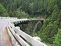
This is the one lane bridge on SR165 about 2 miles south of Carbonado, Washington, on the way to Mt. Rainer.
-
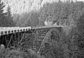
The 494-foot long Fairfax Bridge was the highest bridge in the state when it was built in 1921.
-
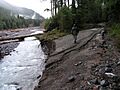
In some places, the 2006 flood of the Carbon River tore away large pieces of the Carbon River Road.


