Carbonado, Washington facts for kids
Quick facts for kids
Carbonado, Washington
|
|
|---|---|

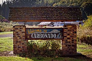
Welcome sign in Carbonado
|
|

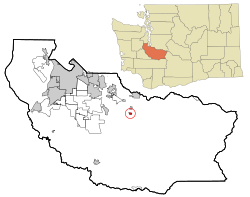
Location of Carbonado, Washington
|
|
| Country | United States |
| State | Washington |
| County | Pierce |
| Area | |
| • Total | 0.42 sq mi (1.08 km2) |
| • Land | 0.42 sq mi (1.08 km2) |
| • Water | 0.00 sq mi (0.00 km2) |
| Elevation | 1,191 ft (363 m) |
| Population
(2020)
|
|
| • Total | 734 |
| • Density | 1,766.83/sq mi (681.61/km2) |
| Time zone | UTC-8 (Pacific (PST)) |
| • Summer (DST) | UTC-7 (PDT) |
| ZIP code |
98323
|
| Area code(s) | 360 |
| FIPS code | 53-09970 |
| GNIS feature ID | 1517390 |
Carbonado (say "car-buh-NAY-doh") is a small town in Pierce County, Washington, in the United States. It's located near the Carbon River, about 50 miles (80 km) southeast of Seattle. Carbonado is the last town you pass through before reaching Mount Rainier National Park. It's also a popular spot for off-roading, which is driving vehicles on unpaved roads.
In the late 1800s and early 1900s, Carbonado was a very important coal mining town. It had the biggest coal mine in Pierce County. In 2020, 734 people lived there.
Contents
History of Carbonado
Carbonado was one of several towns that grew quickly in the Carbon River valley. This happened because cities like Seattle and Tacoma needed a lot of raw materials. Towns like Wilkeson, Burnett, Carbonado, and Fairfax popped up along the valley. They stretched all the way to the edge of Mount Rainier National Park.
Most of these towns were "company towns." This means a large company owned the land, the houses, and even the energy sources. In Carbonado, the company owned everything, and the main resource was coal. The people living there worked for the coal company.
Mining was dangerous work. More than 100 miners died in accidents in Carbonado and nearby areas. For example, 31 miners were killed in an explosion in Mine Number 7 on December 9, 1899.
During its busiest time, Carbonado grew almost as big as Tacoma. A railroad line went all the way up the valley, connecting the towns. Many Polish immigrants settled nearby, providing fresh milk and eggs to the towns. Two of these old farms still exist today.
However, the good times didn't last. The economy slowed down, and people didn't need as much of the lower-quality coal from Carbonado. The demand for timber also dropped. Because of this, Carbonado's population shrank a lot. Today, it's mostly a place where people live, but they work in other towns. The railroad tracks were removed, and much of the old rail line is now part of a walking and biking trail.
You can still see signs of Carbonado's mining past. There's a cemetery, old abandoned mines, and a hill that used to be a pile of coal waste. The town still has a school, the Carbonado Historical School District, where kids from kindergarten to 8th grade attend. Many of the houses built by the mining company still stand on Main Street. They look very similar because they were all built in the same style. Some of the people living in these houses today are direct descendants of the original miners.
Carbonado officially became a town on September 13, 1948.
Geography
Carbonado is located at 47.079724 degrees north latitude and -122.051433 degrees west longitude.
The United States Census Bureau says the town covers a total area of 0.42 square miles (1.08 square kilometers). All of this area is land.
Population Information
The population of Carbonado has changed over the years:
| Historical population | |||
|---|---|---|---|
| Census | Pop. | %± | |
| 1890 | 705 | — | |
| 1950 | 412 | — | |
| 1960 | 424 | 2.9% | |
| 1970 | 394 | −7.1% | |
| 1980 | 456 | 15.7% | |
| 1990 | 495 | 8.6% | |
| 2000 | 621 | 25.5% | |
| 2010 | 610 | −1.8% | |
| 2020 | 734 | 20.3% | |
| U.S. Decennial Census 2020 Census |
|||
2010 Census Details
In 2010, there were 610 people living in Carbonado. These people lived in 208 households, and 153 of these were families. The town had about 1,452 people per square mile (561 people per square kilometer).
Most of the people in Carbonado were White (93.1%). There were also smaller numbers of African American, Native American, and Asian residents. About 4.8% of the population was Hispanic or Latino.
About 40% of the households had children under 18 living with them. Most households (57.7%) were married couples living together. The average household had about 2.93 people.
The average age of people in Carbonado was 34.9 years. About 43% of residents were under 18 years old. About 10% were 65 years or older. The town had slightly more males (52.5%) than females (47.5%).
Famous People from Carbonado
- Frank Robinson, who started the Robinson Helicopters, was born in Carbonado in 1930.
- Paul Strand, a professional baseball pitcher, was born in Carbonado in 1893.
See also
 In Spanish: Carbonado (Washington) para niños
 | Precious Adams |
 | Lauren Anderson |
 | Janet Collins |

