Cortes Bank facts for kids
Quick facts for kids Cortes Bank |
|
|---|---|

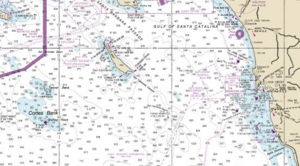
Cortes Bank near San Diego
|
|
| Coordinates | 32°28′41″N 119°12′54″W / 32.478°N 119.215°W |
Cortes Bank is a shallow seamount in the North Pacific Ocean. A seamount is like an underwater mountain or a barely submerged island. It is located about 96 miles southwest of San Pedro, Los Angeles. It is also 111 miles (166 kilometers) west of Point Loma, San Diego. This bank is considered the farthest point in California's Channel Islands chain.
Over long periods of geologic history, Cortes Bank has sometimes been an island. This depended on how high or low the sea level was. The last time it was a large island was about 10,000 years ago. This was during the last ice age. It's possible that the first people to live on the Channel Islands visited this island. They might have seen it from high places on San Clemente Island on clear days.
The shallower parts of Cortes Bank stretch for about 15–18 miles. They are made of sandstone and basalt rock. These parts rise from the ocean floor which is about 1000 fathoms deep (over a mile). The bank looks more like a flat-topped mesa that has been shaped by waves. It has a few hard, basaltic high spots along its length.
The shallowest point is called Bishop Rock. It is only 3 to 6 feet (1–2 m) below the surface. You can sometimes see the rock during very low tides. It might even be visible in the trough of passing waves. Other shallow spots also create huge waves. These spots are 30 to 100 feet deep and can be dangerous for ships. Nine Fathom spot is about 4.5 miles (7 kilometers) northwest of Bishop Rock. It is about 54 feet (18 m) below the surface. Both Bishop Rock and Nine Fathom spot are popular scuba diving places. They have clear water, large kelp forests, and lots of sea life. Bishop Rock is also famous for surfing. It creates some of the biggest surfable waves in the world.
Contents
Exploring Cortes Bank's History
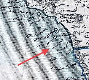
For a long time, Cortes Bank was known as San Juan Island on maps.
Early Discoveries and Naming
US Navy Lt. James Alden and Captain Jonathan "Mad Jack" Percival first reported seeing the seamount. This happened on January 5, 1846. Their ship, the frigate USS Constitution, was sailing off the US West Coast. The ship's logbook mentioned seeing "breakers" (waves breaking over a shallow area) about 10 miles away. Even in 1851, maps like the Tallis map still showed a "San Juan Island" in this area.
In 1853, the captain of the steamship Cortes, TP Cropper, saw the seas "in violent commotion" over a low-lying island. He thought it might be a volcano. The seamount was later named after his ship, the Cortes.
James Alden, who had seen the bank earlier, later worked for the United States Coast Survey. This group was responsible for mapping the US coastline. After the Cortes sighting, Alden sent the USS Ewing to find the exact location of the breakers. Lt. TH Stevens mapped the precise coordinates, calling it "Cortez Bank." Stevens found waters around 54 feet deep. However, he missed the very shallow area around Bishop Rock. So, it didn't appear on the first Coast Survey map in 1853.
The Story of Bishop Rock
Today, Bishop Rock is marked by a warning buoy. It was named after the clipper ship Stillwell S. Bishop. This ship reportedly hit the rock in 1855. It then sailed to San Francisco with a damaged hull. There's some debate if the Bishop actually hit the rock. But its captain, William Shankland, definitely encountered big waves there.
After the Bishop's voyage, James Alden sent Lt. Archibald MacRae to find the shallowest part of the Bank. On November 3, 1855, The New York Times reported MacRae's discovery. It also said he and his crew had marked the spot with flags on floating barrels. Sadly, MacRae died two weeks later in San Francisco Bay.
Treasure Hunts and Island Dreams
In 1957, Mel Fisher explored Cortes Bank looking for treasure. He believed a Spanish galleon (a large sailing ship) had sunk near Bishop Rock. His expedition didn't find any treasure. In fact, the ship he was using almost burned down.
There were also at least two attempts to turn Cortes Bank into its own island nation. One famous attempt happened in 1966. A group of business people planned to create a constitutional monarchy called Abalonia. They wanted to sink a WWII-era concrete freighter on top of Bishop Rock. Then they would surround it with boulders to make a seafood processing factory. They thought international law would let them create their own nation because the bank was in international waters. However, the same giant waves that surfers ride today destroyed the ship. The crew barely escaped. The wreck of the Jalisco (the ship's later name) is now in three pieces underwater. It is a popular diving spot.
Later, another company wanted to form a nation called Taluga. But the US government declared that Cortes Bank was US territory. This is because it is part of the continental shelf.
On November 2, 1985, the aircraft carrier USS Enterprise (CVN-65) hit the Cortes Bank reef. This happened about one mile east of Bishop Rock. The collision caused a 60-foot (18 m) gash in its outer hull. It also ripped off part of its keel and damaged its propeller blades. The ship continued its operations. Later, it went to the Hunter's Point Naval Shipyard in San Francisco for repairs.
Surfing Giant Waves at Cortes Bank
Cortes Bank is famous for its huge waves.
Early Surfing Adventures
In the summer of 1961, Harrison Ealy was one of the first people to surf a wave at Bishop Rock. Around 1973, surfer Ilima Kalama almost died when his abalone fishing boat sank on Bishop Rock at night.
In the early 1990s, Larry Moore, a photo editor, and Mike Castillo, a surfer and pilot, flew over the bank. They had heard rumors of giant waves. In 1990, during a huge swell, they saw empty waves breaking. These waves were an astonishing 80 to 90 feet tall! By 1995, Moore had photographed these waves. That year, he led an expedition with surfers like Sam George, Bill Sharp, and George Hulse. They found smaller, but very smooth, 15-foot waves. George Hulse was the first to catch one. Bill Sharp joked that he wrote his will before that trip.
Record-Breaking Rides
Surfers often plan carefully for the perfect conditions at Cortes Bank. In 2001, a storm in the Gulf of Alaska and a high-pressure system over California created huge waves with light winds. A team of surfers, including Ken Collins, Peter Mel, Brad Gerlach, and Mike Parsons, went out on a boat. On January 19, 2001, they found smooth conditions and enormous waves. These waves were half a mile long and broke across about 1 mile (1.5 kilometers) of reef.
Larry Moore photographed from a plane. Dana Brown filmed from a boat for his surf movie Step Into Liquid. Fran Battaglia also filmed from other boats for his wave science film. Mike Parsons was towed into the wave of the day. His first ride at Cortes Bank was estimated to be 66 feet (20 m) tall. This ride won him his first Guinness World Record. It also won the Swell XXL Biggest Wave Award (now Billabong XXL) and $66,000.
On January 5, 2008, Mike Parsons, Brad Gerlach, Grant "Twiggy" Baker, and Greg Long returned to Cortes Bank. This was during one of the worst storms ever recorded off California. Mike Parsons rode a wave even bigger than his 2001 record. Judges estimated it to be over 70 feet tall, later confirmed as at least 77 feet. Parsons earned his second Guinness World Record. Witnesses agreed that Greg Long rode an even bigger wave, between 80 and 90 feet. However, it was not captured on photo or video. The dangerous conditions made it very hard to photograph.
Even though it is far away, Cortes Bank attracts many surfers when conditions are right. In January 2004, Sean Collins counted 10 to 12 boats with about 40 surfers there.
 | Jessica Watkins |
 | Robert Henry Lawrence Jr. |
 | Mae Jemison |
 | Sian Proctor |
 | Guion Bluford |


