
Seamount facts for kids
A seamount is like an underwater mountain that rises from the ocean floor but doesn't reach the surface to become an island. Most seamounts are formed by submarine volcanoes, which are volcanoes that erupt underwater. They are usually very tall, rising about 1,000 to 4,000 meters (3,000 to 13,000 feet) from the seabed.


The tops of these underwater mountains are often thousands of meters below the ocean's surface, deep in the sea. Scientists believe there are around 100,000 seamounts hidden across the globe, but only a small number of them have been explored. Seamounts come in many different shapes and sizes. They also follow a pattern of growing, being active, and then becoming inactive. In recent years, scientists have seen some seamounts that are still active, like the Loihi seamount near Hawaii.
Contents
What Lives on Seamounts?
Seamounts are home to some of the most common oceanic ecosystems in the world. Because they rise up from the seafloor, they change how underwater currents flow. This helps bring tiny plankton and other food to the area. This is why seamounts attract many different kinds of sea creatures, including corals, fish, and even large sea mammals like cetacea (whales and dolphins).
Fishermen have also noticed that seamounts are great places to find fish. Many seamounts support large commercial fishing areas. However, there are worries about how fishing affects these special underwater homes. There have been many cases where fish populations have dropped a lot. About 95% of the damage is caused by a method called bottom trawling. This method uses large nets that drag along the seafloor, literally scraping away entire ecosystems from the seamounts.
Finding and Mapping Seamounts
Most seamounts have not yet been studied, or even mapped out. Scientists use special technologies like Bathymetry and satellite altimetry to collect data about them. Bathymetry uses sound waves to measure the depth and shape of the seafloor, while satellite altimetry uses satellites to measure the height of the sea surface, which can show where large underwater mountains are.
Sometimes, ships have accidentally hit seamounts that were not on their maps. For example, the Muirfield seamount is named after the ship that crashed into it in 1973.
Dangers from Seamounts
One of the biggest dangers from seamounts comes from something called "flank collapses." As seamounts get older, water pressure can push water into their sides. This can cause huge underwater landslides. These landslides can sometimes create massive tsunamis, which are giant ocean waves that can cause a lot of damage when they reach land.
Related pages
Images for kids
-
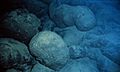
Pillow lava is a type of rock that forms when hot lava erupts underwater and cools quickly.
-
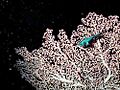
A Grenadier fish and bubblegum coral on the Davidson Seamount. These are two species that are attracted to seamounts.
-
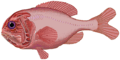
Because of too much fishing, the number of orange roughy fish has dropped a lot. It might take many years for them to recover.
-
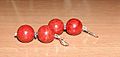
Coral earrings like these are often made from coral found on seamounts.
-
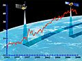
This graph shows how much the global sea level has risen over time.


_in_dry_dock_to_assess_damage_sustained_after_running_aground_approximately_350_miles_south_of_Guam_Jan._8,_2005.jpg)
See also
 In Spanish: Monte submarino para niños
