Humptulips River facts for kids
Quick facts for kids Humptulips River |
|
|---|---|

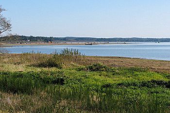
Mouth of the Humptulips River at Grays Harbor
|
|
|
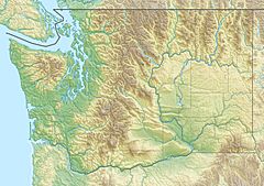
Mouth of the Humptulips River in Washington
|
|
| Country | United States |
| State | Washington |
| Physical characteristics | |
| Main source | Olympic Mountains |
| River mouth | Pacific Ocean Copalis Crossing 47°2′28″N 124°3′16″W / 47.04111°N 124.05444°W |
| Length | 50 mi (80 km) |
| Basin features | |
| Basin size | 276 sq mi (710 km2) |
The Humptulips River is a river found in Grays Harbor County, Washington, in the United States. It is made up of two main parts: the East Fork Humptulips River and the West Fork Humptulips River. These "forks" are like smaller rivers that join to form the main river.
The East Fork is about 20 miles (32 km) long, and the West Fork is about 30 miles (48 km) long. After they meet, the main Humptulips River flows for about 20 miles (32 km). The river's water comes from a large area called a drainage basin, which covers about 276 square miles (710 km2).
The amount of water flowing in the river changes. On average, it carries about 1,344 cu ft/s (38.1 m3/s) of water. The most water ever recorded was 37,500 cu ft/s (1,060 m3/s) in November 2006. The least water was 82 cu ft/s (2.3 m3/s) in September 1944.
The river's name, Humptulips, comes from the Humptulips Indians. They were a group of people who were part of the Chehalis tribe. Some people say "humptulips" means "hard to pole" (like pushing a boat with a long stick). Others say it means "chilly region."
Contents
Where the Humptulips River Starts and Flows
The Humptulips River begins in the Olympic National Forest. It starts as two separate parts: the East Fork and the West Fork. This area, called the Olympic Peninsula, gets a lot of rain every year, about 220 inches (5,600 mm). This rain helps fill many streams that feed the river.
The Forks of the River
The East and West Forks are separated by a place called Humptulips Ridge. The West Fork is also separated from another river, the Quinault River, by Quinault Ridge. The East Fork is separated from the Wynoochee River by Fitzgerald Peak.
Both forks flow south and southwest out of the mountains. They join together about 4.5 miles (7.2 km) before reaching the town of Humptulips.
Journey to the Ocean
Near the town of Humptulips, the river flows under U.S. Route 101. Just below the town, there is a place called the Humptulips Salmon Hatchery. This hatchery is located where Stevens Creek, a smaller stream, joins the Humptulips River.
After the hatchery, the river turns south. It flows for a few more miles before reaching its end at North Bay of Grays Harbor. Grays Harbor is a large bay that connects to the Pacific Ocean. There are two small towns close to where the river meets the bay: Copalis Crossing and Tulips.
Sometimes, the Humptulips River is thought of as the westernmost part of the Chehalis River system. This is because both rivers flow into Grays Harbor.
Nature and History of the River
The Humptulips River is always changing its shape. It slowly wears away its banks, which is called erosion. It's estimated that about 9 acres (36,000 m2) of land is washed away each year. This erosion is partly due to a lot of logging that has happened in the river's area.
Logging and Its Impact
The East Fork area, in particular, has seen a lot of logging. Most of the land around the river is used for commercial forests. There are also some areas with farms for animals and crops. The very beginning of the Humptulips River is managed by the Olympic National Park.
In the past, about 30 splash dams were built on the river. These dams were used to help move logs down the river. However, they caused a lot of harm to the native salmon populations. To help the salmon, several salmon hatcheries have been built.
Towns Along the River
Small towns like Humptulips, Copalis Crossing, and Tulips are located right along the Humptulips River. The bigger cities nearby are Hoquiam and Aberdeen. These cities are located where the Chehalis River meets Grays Harbor.
 | Misty Copeland |
 | Raven Wilkinson |
 | Debra Austin |
 | Aesha Ash |


