Alaska boundary dispute facts for kids
The Alaska boundary dispute was a big argument about where the border should be between Canada and the United States. At the time, the United Kingdom handled Canada's international matters. So, the argument was really between the U.S. and Britain. Before the U.S. bought Alaska, the Russian Empire and Britain had been arguing about this border since 1821. When the United States bought Alaska in 1867, the argument became theirs. The problem was finally solved in 1903. A special group decided the border, giving the U.S. land that connected Canada's Yukon gold fields to the ocean.
Contents
Why the Border Was a Problem
Early Agreements (1825–1898)
In 1825, Russia and Britain signed a deal called the Treaty of Saint Petersburg. This treaty tried to draw the lines for their lands. Russia owned what is now Alaska, and Britain owned what is now British Columbia, Canada. The border was supposed to follow the Portland Channel and then go into the mountains.
Later, in 1839, two big trading companies made an agreement. The Russian-American Company (RAC) let the Hudson's Bay Company (HBC) use part of the Alaskan Panhandle. This area was important for their fur trade. In return, the HBC gave the RAC some farm products, animals, and furs every year. This agreement ended when Russia sold Alaska.
The United States bought Alaska from Russia in 1867. This was known as the Alaska Purchase. However, the exact border lines were still not clear. The United States and Canada could not agree on where the border should be.
The Klondike Gold Rush
In 1897 and 1898, many people rushed to the Klondike Gold Rush in Yukon, Canada. About 30,000 settlers moved there. Around 100,000 people traveled through Alaska to reach the gold fields. This sudden rush made the border problem much more important.
Canada wanted a way for its gold miners to get from the gold fields to a seaport that was completely within Canada. The Canadian government sent police and soldiers to the area. They set up a camp at Fort Selkirk. This way, they could quickly help if any problems came up because of the unclear border.
How the Border Was Decided
In September 1898, the United States and Canada started talking about the border again. But they still could not agree on a line. Both governments argued about what certain words in the 1825 treaty really meant.
Finally, in 1903, the Hay–Herbert Treaty was signed. This agreement between the U.S. and Britain decided to let a neutral group make the decision for them. This way of solving a disagreement is called arbitration. Three Americans, two Canadians, and one Briton were on this special group.
The group had to decide on six main things:
- Where the border should begin.
- What "Portland Channel" meant and how to draw the line through it. Four islands in this area were part of the argument.
- How to draw the line from the southernmost point of Prince of Wales Island to Portland Channel. This depended on the answer to the question above.
- The line from Portland Channel to the 56th parallel north.
- How wide the "border or edge" (called lisière in French) should be, and how to measure it.
- If there were really mountain ranges in the area as described in the old treaty.
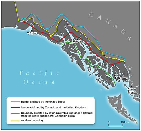
Lord Alverstone, the Briton on the group, sided with the Americans on some key points. The final border was not exactly what either side wanted at first. However, each country did get some of the land they had claimed. You can see the new borders on the map at the top of this article.
What Happened Next
Canada's New Identity
To keep peace, Britain had offered the U.S. some fishing rights and control over the Panama Canal. When the border decision was made, Canadians felt that Britain had let them down. This feeling made Canada believe that it should be more independent from the British crown. This desire for Canada to control its own international matters may have led to the Statute of Westminster. This important law gave Canada more control over its own foreign policy.
Interesting facts about the Alaska boundary dispute
- Before Alaska belonged to America, it belonged to Russia. Russia had made an agreement with Britain about the general border between their two colonies.
- The discovery of gold in the Klondike brought more attention to the unclear border between Alaska and Canada.
- The Canadian government wanted to survey the land, but America thought it would be too expensive.
- The border area was on land where the Tlingit and Haida peoples lived.
- The Canadians and Americans agreed to let the decision be made by an arbitration committee.
- Four islands in the Portland Canal were argued about during the arbitration process. Two islands were given to each country.
- The entrance to the Klondike was through an inlet called the Lynn Canal. It was given to the United States.
See also
 In Spanish: Disputa limítrofe de Alaska para niños
 | Emma Amos |
 | Edward Mitchell Bannister |
 | Larry D. Alexander |
 | Ernie Barnes |


