Alexander Archipelago facts for kids
| Geography | |
|---|---|
| Location | Pacific Ocean |
| Coordinates | 56°40′00″N 134°05′00″W / 56.66667°N 134.08333°W |
| Administration | |
|
United States
|
|
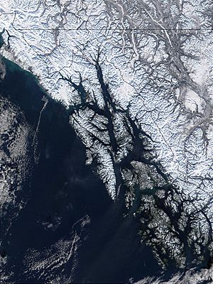
The Alexander Archipelago is a huge group of islands found off the southeastern coast of Alaska. It stretches about 300 miles (480 km) long. These islands are actually the tops of old coastal mountains. They rise steeply out of the Pacific Ocean.
Deep, narrow waterways called fjords separate the islands. These waterways also cut the islands off from the mainland. The islands help protect the northern part of the Inside Passage. This is a famous water route that winds its way through the islands.
The islands have rough, steep coasts. They are covered with thick evergreen and temperate rain forests. Most of these islands can only be reached by boat or plane. A large part of the islands belongs to the Tongass National Forest.
Some of the biggest islands include Prince of Wales Island, Chichagof Island, Admiralty Island, and Baranof Island. Other large islands are Revillagigedo Island, Kupreanof Island, and Kuiu Island. All the islands are rugged and covered in dense forests. They are also home to lots of different wildlife.
The Tlingit and Kaigani Haida people have lived in this area for a very long time. The Tsimshian people on Annette Island moved to the region later. They came from British Columbia in the late 1800s.
Ketchikan on Revillagigedo Island is one of the largest towns. Sitka on Baranof Island is another big town. The main parts of Juneau, the region's largest city, are on the mainland. However, some parts of Juneau are on Douglas Island, which is part of the archipelago.
The main ways people make a living here are through tourism, fishing, and logging.
Contents
Exploring the History of the Islands
Early European Visitors to the Archipelago
The first European to see these islands was a Russian explorer. His name was Aleksei Chirikov, and he visited in 1741. He saw the coasts of Noyes and Baker Islands. He also saw Baranof, Chichagof, Kruzof, and Yakobi Islands.
Later, in 1774, Juan José Pérez Hernández saw the south coast of Dall Island. The next year, Juan Francisco de la Bodega y Quadra sailed into Bucareli Bay. This bay is off Prince of Wales Island. In 1792, Jacinto Caamaño saw Revillagigedo Island. He also found the Gravina Islands and Clarence Strait.
Mapping the Islands with George Vancouver
George Vancouver and his crew explored the islands in detail. They did this in 1793 and 1794. They sailed all the way around Revillagigedo and Admiralty Islands. They also mapped all of Kuiu Island. They charted the eastern sides of Baranof and Chichagof Islands. They also mapped Etolin, Wrangell, Zarembo, Mitkof, and Kupreanof Islands.
Within ten years, the Russians had traveled through Peril Strait. This strait separates Chichagof and Baranof Islands. In the following years, they found the waterways between other major islands. A Russian map from 1844 showed many islands separated. This included Kupreanof from Mitkof Island. It also showed Etolin, Wrangell, Woronkofski, and Zarembo Islands separated.
Changes in Control and Naming
The islands were an important place for the Maritime fur trade in the early 1800s. This was when people traded animal furs by sea. Control of the islands later moved from Russia to the United States. This happened with the Alaska Purchase in 1867.
The Alexander Archipelago got its name in 1867. This was given by the U.S. Coast and Geodetic Survey. The island chain is named after Tsar Alexander II of Russia. An 1860 Russian map of Alaska called the islands the King George III Archipelago.
See also
 In Spanish: Archipiélago Alexander para niños
 | Sharif Bey |
 | Hale Woodruff |
 | Richmond Barthé |
 | Purvis Young |


