Hyder, Alaska facts for kids
Quick facts for kids
Hyder, Alaska
|
|
|---|---|

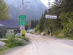
The border between Stewart, British Columbia, and Hyder, as seen from the Canadian side.
|
|

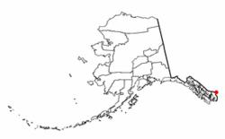
Location of Hyder, Alaska.
|
|
| Country | United States |
| State | Alaska |
| Census area | Prince of Wales–Hyder |
| Area | |
| • Total | 17.07 sq mi (44.21 km2) |
| • Land | 17.07 sq mi (44.21 km2) |
| • Water | 0.00 sq mi (0.00 km2) |
| Elevation | 118 ft (36 m) |
| Population
(2020)
|
|
| • Total | 48 |
| • Density | 2.81/sq mi (1.09/km2) |
| Time zone | Official time: Alaska (AKST) Unofficial time: PST |
| • Summer (DST) | Official time: AKDT Unofficial time: PDT |
| ZIP Code |
99923
|
| Area code(s) | 236, 250, 672, 778 |
| FIPS code | 02-34570 |
| GNIS feature ID | 1422711 |
Hyder is a small community in Alaska, United States. It's known as a census-designated place, which is a special type of community defined by the U.S. Census Bureau. In 2020, only 48 people lived there.
Hyder is unique because you can only reach it by road from Stewart, British Columbia, a town in Canada. This makes it a popular spot for people who want to visit Alaska without driving the long Alaska Highway. It's also the easternmost community in Alaska.
Contents
Where is Hyder, Alaska?
Hyder is located at the very end of the land border between Alaska and British Columbia, Canada. It sits at the top of the Portland Canal, which is a long, narrow body of water called a fjord. This fjord is about 130 miles (209 km) long and forms part of the border.
The town is only about 2 miles (3.2 km) by road from Stewart, British Columbia. If you wanted to fly to Ketchikan, it would be about 75 miles (121 km) away. The total area of Hyder is about 14.8 square miles (38.3 sq km), and it's all land.
What's the Weather Like in Hyder?
Hyder has a climate that's typical for southeastern Alaska. It's often described as an oceanic climate, which means it has cool summers and mild winters, with lots of rain. It's also very wet, especially compared to some other places.
| Climate data for Hyder, Alaska (1991–2020 normals, extremes 1936–present) | |||||||||||||
|---|---|---|---|---|---|---|---|---|---|---|---|---|---|
| Month | Jan | Feb | Mar | Apr | May | Jun | Jul | Aug | Sep | Oct | Nov | Dec | Year |
| Record high °F (°C) | 48 (9) |
51 (11) |
63 (17) |
73 (23) |
86 (30) |
94 (34) |
94 (34) |
93 (34) |
84 (29) |
66 (19) |
54 (12) |
46 (8) |
94 (34) |
| Mean maximum °F (°C) | 40.1 (4.5) |
42.9 (6.1) |
50.6 (10.3) |
63.4 (17.4) |
76.4 (24.7) |
82.5 (28.1) |
83.4 (28.6) |
81.2 (27.3) |
69.4 (20.8) |
58.4 (14.7) |
45.2 (7.3) |
40.4 (4.7) |
88.8 (31.6) |
| Mean daily maximum °F (°C) | 31.2 (−0.4) |
35.2 (1.8) |
42.3 (5.7) |
51.2 (10.7) |
61.9 (16.6) |
66.7 (19.3) |
68.1 (20.1) |
66.5 (19.2) |
58.8 (14.9) |
47.9 (8.8) |
37.5 (3.1) |
32.1 (0.1) |
50.0 (10.0) |
| Daily mean °F (°C) | 26.8 (−2.9) |
29.7 (−1.3) |
34.9 (1.6) |
42.0 (5.6) |
50.8 (10.4) |
57.1 (13.9) |
59.7 (15.4) |
58.2 (14.6) |
52.1 (11.2) |
42.3 (5.7) |
33.7 (0.9) |
28.1 (−2.2) |
42.9 (6.1) |
| Mean daily minimum °F (°C) | 22.4 (−5.3) |
24.2 (−4.3) |
27.5 (−2.5) |
32.8 (0.4) |
39.7 (4.3) |
47.4 (8.6) |
51.2 (10.7) |
49.9 (9.9) |
45.3 (7.4) |
36.7 (2.6) |
30.0 (−1.1) |
24.0 (−4.4) |
35.9 (2.2) |
| Mean minimum °F (°C) | 5.6 (−14.7) |
8.6 (−13.0) |
15.9 (−8.9) |
24.6 (−4.1) |
32.7 (0.4) |
39.8 (4.3) |
45.2 (7.3) |
42.7 (5.9) |
36.6 (2.6) |
28.5 (−1.9) |
17.5 (−8.1) |
10.1 (−12.2) |
−0.7 (−18.2) |
| Record low °F (°C) | −15 (−26) |
−3 (−19) |
3 (−16) |
16 (−9) |
28 (−2) |
33 (1) |
33 (1) |
33 (1) |
33 (1) |
20 (−7) |
−1 (−18) |
−6 (−21) |
−15 (−26) |
| Average precipitation inches (mm) | 11.03 (280) |
5.76 (146) |
5.95 (151) |
4.11 (104) |
4.80 (122) |
3.48 (88) |
4.74 (120) |
8.77 (223) |
11.19 (284) |
12.06 (306) |
12.00 (305) |
8.64 (219) |
92.53 (2,350) |
| Average snowfall inches (cm) | 53.7 (136) |
34.7 (88) |
27.0 (69) |
1.7 (4.3) |
0.0 (0.0) |
0.0 (0.0) |
0.0 (0.0) |
0.0 (0.0) |
0.0 (0.0) |
1.1 (2.8) |
31.3 (80) |
39.9 (101) |
189.4 (481.1) |
| Average precipitation days (≥ 0.01 in) | 22.2 | 13.8 | 21.3 | 16.0 | 10.4 | 15.1 | 17.8 | 17.0 | 19.8 | 18.8 | 22.4 | 18.6 | 213.2 |
| Average snowy days (≥ 0.1 in) | 13.0 | 9.4 | 8.0 | 0.8 | 0.0 | 0.0 | 0.0 | 0.0 | 0.0 | 1.2 | 8.8 | 12.5 | 53.7 |
| Source: NOAA | |||||||||||||
People of Hyder
| Historical population | |||
|---|---|---|---|
| Census | Pop. | %± | |
| 1920 | 237 | — | |
| 1930 | 254 | 7.2% | |
| 1940 | 72 | −71.7% | |
| 1950 | 30 | −58.3% | |
| 1960 | 32 | 6.7% | |
| 1970 | 49 | 53.1% | |
| 1980 | 77 | 57.1% | |
| 1990 | 99 | 28.6% | |
| 2000 | 97 | −2.0% | |
| 2010 | 87 | −10.3% | |
| 2020 | 48 | −44.8% | |
| U.S. Decennial Census | |||
Hyder first appeared on the U.S. Census in 1920. It was counted as a small, unincorporated village. In 1980, it became a census-designated place (CDP).
In 2000, there were 97 people living in Hyder. Most residents were White, and a few were of two or more races. There was also one person of Hispanic or Latino background.
The population was spread out across different age groups. There were some children under 18, and many adults between 45 and 64 years old. The average age was 46 years.
Getting Around Hyder
Hyder is right next to Stewart, British Columbia. You can easily drive between the two towns on International Street. Outside of Hyder, a road called NFD-88 goes north through the Tongass National Forest. This road eventually becomes Granduc Road in Canada.
There are not many local roads in Hyder itself. Also, no roads connect Hyder to other towns in Alaska directly. You always have to go through Canada to reach other places by car. The ferry service that used to connect Hyder to Ketchikan stopped in the 1990s. Now, the only direct public transport to the rest of Alaska is a floatplane that brings mail twice a week to Hyder Seaplane Base.
Services and Utilities
Even though Hyder is small, it has a few important services:
- The United States Postal Service has an office there.
- The United States Forest Service has an information kiosk and a place to watch wildlife.
- The Hyder Community Association runs a museum, an information center, and a library.
Interestingly, Hyder gets its electricity from Canada. A company called Tongass Power and Light, which is part of BC Hydro, provides power. Also, Hyder uses Canadian phone area codes (236, 250, and 778) instead of Alaska's 907 area code. Even though Hyder is officially in the Alaska Time Zone, people there usually set their clocks to Pacific Time, just like in British Columbia. Both U.S. and Canadian money are accepted in Hyder, except at the U.S. Post Office, which only takes U.S. dollars.
Hyder's Past: A Mining Town
Long ago, the Nisga'a people lived near the Nass River. They called the area at the head of Portland Canal "Skam-A-Kounst," which means safe place. They probably used it as a safe spot from the Haidas who lived on the coast. The Nisga'a would visit the area to pick berries.
In 1896, Captain D.D. Gaillard explored the Portland Canal area. Then, in 1898, gold and silver were found nearby, mostly on the Canadian side of the border. The Stewart brothers, who later had the Canadian town of Stewart named after them, arrived in 1902.
Hyder was first started in 1907 and was called "Portland City." But in 1914, the U.S. Post Office said there were too many towns named Portland. So, the town was renamed Hyder after Frederick Hyder, a Canadian mining engineer. He believed the area had a bright future. By 1917, Hyder became the main port and supply point for miners.
The 1920s were Hyder's busiest years. The Riverside Mine, on the U.S. side, dug up gold, silver, copper, lead, zinc, and tungsten. This mine operated from 1924 to 1950. In 1928, a big fire destroyed many businesses in Hyder. By 1956, most of the important mining had stopped. However, the Granduc Mine on the Canadian side continued to operate for many years.
Fun Facts and Traditions
Hyder is a popular spot for tourists, with over 100,000 visitors each year in the mid-2010s. It's also famous among long-distance motorcyclists. Every Memorial Day weekend, many riders come to Hyder for an event called "Hyder Seek." This tradition started in 1998 when a rider named Ron Ayres set a record by riding to 49 states, ending his trip in Hyder.
Because Hyder is so close to Stewart, Canada, and far from other Alaskan towns, it shares many things with its Canadian neighbor. Both American and Canadian holidays are celebrated. There's even a shared Chamber of Commerce for both towns.
A fun local tradition is called being "Hyderized." Two of the town's bars give out certificates to people who participate in a special local custom.
Learning in Hyder
The Southeast Island School District is in charge of the Hyder School. Children living in Hyder have sometimes gone to the Bear Valley School in Stewart, Canada. Hyder can have its own school if there are at least 10 children, which is the minimum number Alaska requires to provide a teacher.
Trivia
At the border crossing into Stewart, there's a funny sign that looks like the famous "Checkpoint Charlie" sign from Berlin. It says "You are leaving the American Sector" in English, French, and German, plus another sign that says "Eastern Sektor." This sign was put up in 2015 as a way to protest when Canada planned to close the border control at night.
See also
 In Spanish: Hyder (Alaska) para niños
 | Isaac Myers |
 | D. Hamilton Jackson |
 | A. Philip Randolph |


