
Tri-state area facts for kids
A tri-state area is a common way to talk about a place in the United States where parts of three different states meet or are very close. These areas usually share a big city or a strong connection in their economy and geography. You often hear the term "tri-state area" in TV and radio ads!
Contents
Famous Tri-State Areas
Many parts of the U.S. are called tri-state areas. Here are some of the most well-known ones:
- The area around New York City includes parts of New York, New Jersey, and Connecticut. Sometimes, a bit of Pennsylvania is also included, making it a "four-state" area!
- The Philadelphia area covers parts of Pennsylvania, New Jersey, and Delaware. It also includes a small part of Maryland.
- The Cincinnati metropolitan area is where Ohio, Kentucky, and Indiana meet.
- The Boston area includes parts of Massachusetts, Rhode Island, and New Hampshire.
- The Providence metropolitan area is mostly in Rhode Island and a bit of Massachusetts. Even though Connecticut isn't officially part of it, three Rhode Island counties touch Connecticut.
- The Pittsburgh tri-state area covers parts of Pennsylvania, Ohio, and West Virginia.
- The Erie, Pennsylvania, tri-state area includes parts of New York and Ohio.
- The Minisink Valley tri-state region covers Orange County in New York, Sussex County in New Jersey, and Pike County in Pennsylvania.
- The Chicago tri-state area, also called Chicagoland, includes northeast Illinois, northwest Indiana, and southeast Wisconsin. Some parts of Michigan are also connected to Chicago.
- The Greater Memphis area, or Mid-South, includes western Tennessee, northwest Mississippi, and the Arkansas delta.
- The Dubuque, Iowa tri-state area reaches into Illinois and Wisconsin.
- The La Crosse, Wisconsin, tri-state area includes towns in Wisconsin, Minnesota, and Iowa.
- The Chattanooga, Tennessee, tri-state area includes parts of Alabama and Georgia.
- The area around Washington, D.C. and nearby parts of Maryland and Virginia is sometimes called a "tri-state area." Even though D.C. isn't a state, Jefferson County, West Virginia, is part of its official metro area, so it does include three states. People often call this area "the DMV" (D.C., Maryland, Virginia).
- The "Joplin District" is a mining area in Oklahoma, Kansas, and Missouri. It's known for special "tri-state" minerals.
- The Wiregrass Region includes southeast Alabama, southern Georgia, and the Florida Panhandle.
- The Sioux City metropolitan area region is in Iowa, Nebraska, and South Dakota.
- Northwest Litchfield County in Connecticut, southern Berkshire County in Massachusetts, and eastern Dutchess County in New York are sometimes called the "tri-corners."
- The Keokuk, Iowa, tri-state area includes parts of Iowa, Missouri, and Illinois.
- The Illinois–Indiana–Kentucky tri-state area includes Evansville, Indiana, and nearby parts of Illinois and Kentucky.
- The Huntington–Ashland metropolitan area includes towns in ten counties across Kentucky, Ohio, and West Virginia. This area is sometimes called "Kyova," a mix of the state names.
- The Ark-La-Tex is a region that includes counties and parishes in Arkansas, Louisiana, and Texas.
- The Delmarva area includes Delaware and the eastern parts of Maryland and Virginia.
Some of these areas, like Quincy, Evansville, and Huntington–Ashland, are special because the three states are separated by rivers.
Tripoints: Where Three States Meet Exactly
A "tripoint" is a specific spot where the borders of three states come together. In the U.S., there are 62 such points. Most of these are on land, but some are in water.
Land Tripoints
Here are some of the places where three states meet on dry land:
-
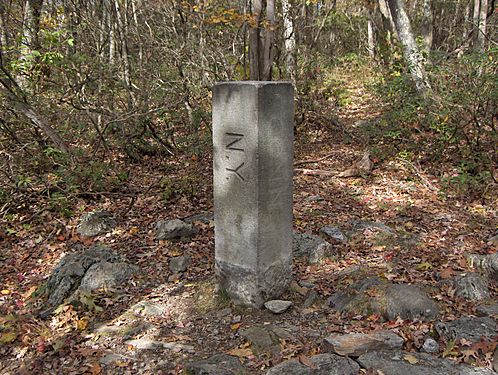
This marker shows where New York, Massachusetts, and Connecticut meet.
-
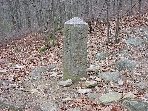
Connecticut, Rhode Island, and Massachusetts meet at this spot.
-
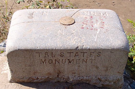
The Tri-States Monument marks where New Jersey, New York, and Pennsylvania come together.
-
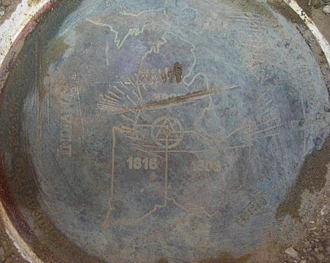
Indiana, Michigan, and Ohio share this tripoint marker.
-
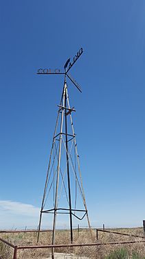
This is the "8 Mile Corner" where Colorado, Kansas, and Oklahoma meet.
-
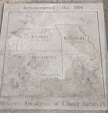
A marker for the Kansas, Missouri, and Oklahoma tripoint.


| State 1 | State 2 | State 3 | Location | Notes |
|---|---|---|---|---|
| Alabama | Florida | Georgia | 31°0′2″N 85°0′8″W / 31.00056°N 85.00222°W | A marker on the Chattahoochee River bank is very close to the actual meeting point. |
| Alabama | Georgia | Tennessee | 34°59′5″N 85°36′19″W / 34.98472°N 85.60528°W | This is called Tri-State Corner. There's a marker on land, but the actual point is also under a lake. The marker was stolen in 2009 and found two years later! |
| Arizona | Nevada | Utah | 37°0′1″N 114°3′2″W / 37.00028°N 114.05056°W | Marked with a red stone monument. |
| Arkansas | Louisiana | Mississippi | 33°0′15″N 91°9′58″W / 33.00417°N 91.16611°W | This point is likely unmarked on a small island in the river. |
| Arkansas | Louisiana | Texas | 33°1′9″N 94°2′35″W / 33.01917°N 94.04306°W | This is part of the Ark-La-Tex region. The marker is slowly being surrounded by a tree! |
| Arkansas | Missouri | Oklahoma | 36°29′58″N 94°37′5″W / 36.49944°N 94.61806°W | Marked with a stone monument. |
| Arkansas | Oklahoma | Texas | 33°38′16″N 94°29′9″W / 33.63778°N 94.48583°W | This point is unmarked and might be on a seasonal island or in the riverbed. |
| California | Nevada | Oregon | 41°59′40″N 119°59′57″W / 41.99444°N 119.99917°W | Marked with a pile of stones called a cairn. |
| Colorado | Kansas | Nebraska | 40°0′11″N 102°3′6″W / 40.00306°N 102.05167°W | Marked with a brass disc. |
| Colorado | Kansas | Oklahoma | 36°59′35″N 102°2′32″W / 36.99306°N 102.04222°W | This is the 8 Mile Corner. The marker is hidden under a removable cover in the ground. |
| Colorado | Nebraska | Wyoming | 41°0′5″N 104°3′12″W / 41.00139°N 104.05333°W | Marked with a stone surrounded by a colorful base. |
| Colorado | New Mexico | Oklahoma | 37°0′0″N 103°0′8″W / 37.00000°N 103.00222°W | Marked by the Preston Monument. |
| Colorado | Utah | Wyoming | 41°0′2″N 109°3′0″W / 41.00056°N 109.05000°W | This point is marked. |
| Connecticut | Massachusetts | New York | 42°2′59″N 73°29′14″W / 42.04972°N 73.48722°W | Found near Brace Mountain or Mount Frissell. Marked with a stone that has the state names carved into it. |
| Connecticut | Massachusetts | Rhode Island | 42°0′29″N 71°47′57″W / 42.00806°N 71.79917°W | Near Thompson, Connecticut. Marked with a stone showing the three states. |
| Delaware | Maryland | Pennsylvania | 39°43′20″N 75°47′19″W / 39.72222°N 75.78861°W | Part of the Delaware Wedge. Marked with a stone. |
| Georgia | North Carolina | Tennessee | 34°59′18″N 84°19′19″W / 34.98833°N 84.32194°W | This point is marked. |
| Idaho | Montana | Wyoming | 44°28′27″N 111°2′56″W / 44.47417°N 111.04889°W | Located inside Yellowstone National Park. It's marked, but hard to get to. |
| Idaho | Nevada | Oregon | 42°0′1″N 117°1′34″W / 42.00028°N 117.02611°W | Marked with a three-sided stone with the state initials. |
| Idaho | Nevada | Utah | 41°59′37″N 114°2′30″W / 41.99361°N 114.04167°W | Marked with a granite monument that has the state names. |
| Idaho | Utah | Wyoming | 42°0′6″N 111°2′48″W / 42.00167°N 111.04667°W | Marked with a stone. |
| Indiana | Michigan | Ohio | 41°41′46″N 84°48′22″W / 41.69611°N 84.80611°W | A brass marker is hidden under a rural road. A granite marker nearby points to it. |
| Iowa | Minnesota | South Dakota | 43°30′1″N 96°27′12″W / 43.50028°N 96.45333°W | The exact point is marked with a disc in the middle of a road intersection. |
| Kansas | Missouri | Oklahoma | 36°59′56″N 94°37′5″W / 36.99889°N 94.61806°W | Marked with a plaque on a quiet road. |
| Kentucky | Tennessee | Virginia | 36°36′3″N 83°40′32″W / 36.60083°N 83.67556°W | This is Tri-State Peak in Cumberland Gap National Historical Park. It's marked. |
| Kentucky | Virginia | West Virginia | 37°32′17″N 81°58′5″W / 37.53806°N 81.96806°W | Marked with a special marker on top of an iron pipe near the river's high point. |
| Maryland | Pennsylvania | West Virginia | 39°43′16″N 79°28′36″W / 39.72111°N 79.47667°W | Marked with a stone shaped like a pyramid. |
| Massachusetts | New Hampshire | Vermont | 42°43′37″N 72°27′30″W / 42.72694°N 72.45833°W | The marker is on land but is now buried in the riverbed because of a dam. |
| Massachusetts | New York | Vermont | 42°44′45″N 73°15′54″W / 42.74583°N 73.26500°W | Marked with a stone. |
| Montana | North Dakota | South Dakota | 45°56′43″N 104°2′44″W / 45.94528°N 104.04556°W | Marked with a red granite stone. |
| Montana | South Dakota | Wyoming | 44°59′51″N 104°3′28″W / 44.99750°N 104.05778°W | Marked with a stone inside a fence. |
| Nebraska | South Dakota | Wyoming | 43°0′2″N 104°3′11″W / 43.00056°N 104.05306°W | Marked with a stone inside a fence. |
| New Jersey | New York | Pennsylvania | 41°21′27″N 74°41′42″W / 41.35750°N 74.69500°W | Marked by the Tri-States Monument in Port Jervis, New York, where the Delaware and Neversink rivers meet. |
| New Mexico | Oklahoma | Texas | 36°30′1″N 103°0′9″W / 36.50028°N 103.00250°W | Marked by the Texhomex Marker. |
| North Carolina | Tennessee | Virginia | 36°35′17″N 81°40′39″W / 36.58806°N 81.67750°W | This is the North Carolina–Tennessee–Virginia Corners and it is marked. |
Water Tripoints
Some tripoints are located in rivers, lakes, or other bodies of water:
| State 1 | State 2 | State 3 | Location | Water Body | Notes |
|---|---|---|---|---|---|
| Alabama | Mississippi | Tennessee | 34°59′44″N 88°12′0″W / 34.99556°N 88.20000°W | Tennessee River | |
| Arizona | California | Nevada | 35°0′7″N 114°38′1″W / 35.00194°N 114.63361°W | Colorado River | |
| Arkansas | Mississippi | Tennessee | 34°59′44″N 90°18′33″W / 34.99556°N 90.30917°W | Mississippi River | This is near the Memphis, Tennessee metro area. |
| Arkansas | Missouri | Tennessee | 36°0′2″N 89°43′59″W / 36.00056°N 89.73306°W | Mississippi River | |
| Connecticut | New York | Rhode Island | 41°18′16″N 71°54′26″W / 41.30444°N 71.90722°W | Long Island Sound | The New York part of this area is Fishers Island. It's part of the New London, Connecticut metro area. |
| Delaware | New Jersey | Pennsylvania | 39°48′7″N 75°24′54″W / 39.80194°N 75.41500°W | Delaware River | This is part of the Philadelphia metro area. |
| Georgia | North Carolina | South Carolina | 35°0′2″N 83°6′31″W / 35.00056°N 83.10861°W | Chatooga River | This point is in the river, very close to a marker on dry land. |
| Idaho | Oregon | Washington | 45°59′43″N 116°54′58″W / 45.99528°N 116.91611°W | Snake River | |
| Illinois | Indiana | Kentucky | 37°47′57″N 88°1′41″W / 37.79917°N 88.02806°W | Wabash River and Ohio River | This is part of the Evansville, Indiana metro area, also known as the Illinois–Indiana–Kentucky tri-state area. |
| Illinois | Indiana | Michigan | 41°45′39″N 87°12′28″W / 41.76083°N 87.20778°W | Lake Michigan | This area is sometimes called the Indiana Dunes or Michigan Dunes Area. |
| Illinois | Iowa | Wisconsin | 42°30′30″N 90°38′27″W / 42.50833°N 90.64083°W | Mississippi River | This is part of the Dubuque, Iowa metro area. |
| Illinois | Kentucky | Missouri | 36°58′51″N 89°8′3″W / 36.98083°N 89.13417°W | Mississippi River and Ohio River | This region is often called a tri-state area with St. Louis, Missouri, Carbondale, Illinois and Paducah, Kentucky as its main cities. |
| Illinois | Michigan | Wisconsin | 42°29′37″N 87°1′12″W / 42.49361°N 87.02000°W | Lake Michigan | |
| Indiana | Kentucky | Ohio | 39°6′20″N 84°49′13″W / 39.10556°N 84.82028°W | Ohio River | This is part of the Cincinnati metro area. |
| Iowa | Illinois | Missouri | 40°22′42″N 91°25′10″W / 40.37833°N 91.41944°W | Mississippi River and Des Moines River | This border is with Lee County, Iowa. |
| Iowa | Minnesota | Wisconsin | 43°30′2″N 91°13′4″W / 43.50056°N 91.21778°W | Mississippi River | This is part of the La Crosse, Wisconsin metro area. A sign used to mark this spot, but it has been moved. |
| Iowa | Missouri | Nebraska | 40°35′7″N 95°45′56″W / 40.58528°N 95.76556°W | Missouri River | |
| Iowa | Nebraska | South Dakota | 42°29′26″N 96°26′44″W / 42.49056°N 96.44556°W | Big Sioux River and Missouri River | This is part of the Sioux City, Iowa metro area. |
| Kansas | Missouri | Nebraska | 40°0′0″N 95°18′30″W / 40.00000°N 95.30833°W | Missouri River | |
| Kentucky | Missouri | Tennessee | 36°29′54″N 89°32′22″W / 36.49833°N 89.53944°W 36°29′52″N 89°29′6″W / 36.49778°N 89.48500°W 36°29′57″N 89°25′6″W / 36.49917°N 89.41833°W |
Mississippi River | There are actually three separate meeting points here because the river bends a lot. |
| Kentucky | Ohio | West Virginia | 38°25′18″N 82°35′45″W / 38.42167°N 82.59583°W | Big Sandy River and Ohio River | This is the Huntington (W.V.)-Ashland (Ky.)-Ironton (Oh.) Tri-State region. |
| Maryland | Virginia | West Virginia | 39°19′17″N 77°43′8″W / 39.32139°N 77.71889°W | Potomac River | This point is unmarked and almost always underwater. |
| Michigan | Minnesota | Wisconsin | 47°17′28″N 89°57′26″W / 47.29111°N 89.95722°W | Lake Superior | |
| Minnesota | North Dakota | South Dakota | 45°56′7″N 96°33′49″W / 45.93528°N 96.56361°W | Bois de Sioux River | This point is not directly marked and is likely in the river. |
| Ohio | Pennsylvania | West Virginia | 40°38′20″N 80°31′8″W / 40.63889°N 80.51889°W | Ohio River | This is technically the starting point for U.S. land surveys, but the actual monument is on land because the true tripoint is underwater. This is part of the Pittsburgh Tri-State area. |
Tri-State Areas Without a Single Meeting Point
Some tri-state areas are important even if the three states don't meet at one exact spot. They are connected by shared geography, economy, or culture.
See also
 In Spanish: Área tri-estatal para niños
