West Tennessee facts for kids
Quick facts for kids
West Tennessee
|
|
|---|---|
|
Grand Division
|
|
|
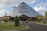
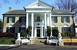
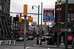
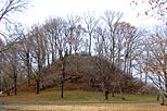
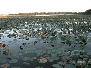
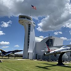
Clockwise, from top left: The Memphis Pyramid, Graceland, Beale Street, Pinson Mounds, Shiloh National Military Park, Reelfoot Lake
|
|
| Nickname(s):
West TN, West Tenn.
|
|

The counties of Tennessee highlighted in red are designated part of West Tennessee.
|
|
| Country | |
| State | |
| Largest city | Memphis |
| Area | |
| • Land | 27,600 km2 (10,650 sq mi) |
| Population
(2020)
|
1,557,649 |
| • Density | 56.47/km2 (146.26/sq mi) |
| Demonym(s) | West Tennessean |
West Tennessee is one of the three main parts of the state of Tennessee. It covers the western quarter of the state. This region includes 21 counties located between the Tennessee River and the Mississippi River.
West Tennessee has mostly flat land with rich soil. It also has large areas that can flood near the Mississippi River. It is the lowest and flattest of Tennessee's three main regions. It is also the smallest in land area and has the fewest people. The biggest city in West Tennessee is Memphis, which is the second largest city in the state.
The Chickasaw people originally lived in West Tennessee. It was the last part of Tennessee to be settled by Europeans. The United States officially gained control of this area in 1818. This happened through a deal called the Jackson Purchase. This was 22 years after Tennessee became a state. Because it is part of the Mississippi River basin, West Tennessee has very fertile soil. This led to a lot of cotton farming before the Civil War. This farming relied heavily on the work of enslaved people.
Contents
History of West Tennessee
Early Explorers and Settlements
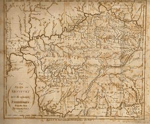
The first Europeans to visit what is now West Tennessee were part of a Spanish trip led by Hernando de Soto in 1541. They were the first Europeans to reach the Mississippi River south of where Memphis is today. In 1673, a French group led by Jacques Marquette and Louis Jolliet explored the Mississippi River. They were the first Europeans to map the Mississippi Valley.
Later, in 1682, a French group led by René-Robert Cavelier, Sieur de La Salle built Fort Prudhomme. This fort was on the Chickasaw Bluffs near the Mississippi River, just north of modern-day Memphis. In 1739, the French built Fort Assumption at the current site of Memphis. They used it as a base during their conflicts with the Chickasaw people.
In 1795, the Spanish governor of Louisiana, Francisco Luis Héctor de Carondelet, sent Manuel Gayoso de Lemos to make a deal with the Chickasaw. This deal allowed the Spanish to build a fort on the Chickasaw Bluffs. Fort San Fernando De Las Barrancas was built in May 1795. It helped the Spanish protect their claims and stop the United States from expanding westward.
Becoming Part of the United States
The land west of the Tennessee River was first recognized as Chickasaw territory in 1786. This was stated in the Treaty of Hopewell. Even after Tennessee became a state in 1796, this area remained Chickasaw land. However, Tennessee's state laws still claimed the region as part of the state.
West Tennessee officially became part of the United States in 1818. This happened through a series of agreements with the Chickasaw. This land deal is known as the Jackson Purchase. It was negotiated by Andrew Jackson, who later became the 7th U.S. President, and former Kentucky governor Isaac Shelby. This purchase also included parts of western Kentucky and northern Mississippi.
After 1818, West Tennessee was opened for European settlement. In the 1820s, cotton farmers started using the rich soil in the region. This led to an economy based on farming, which relied heavily on the labor of enslaved African Americans. West Tennessee quickly became one of the most productive cotton-growing areas in the country.
Civil War and Aftermath
When Abraham Lincoln was elected president in 1860, most people in West Tennessee wanted to join the Confederacy. They wanted to keep their economy, which depended on enslaved labor. However, in the southeastern parts of the region, near the Tennessee River, the land was not good for large plantations. Many people in that area supported the Union. In 1860, more than one-third of West Tennessee's population was enslaved people.
Many important battles and events of the American Civil War happened in West Tennessee.
- In February 1862, the U.S. Navy, led by General Ulysses S. Grant, captured the Tennessee River at the Battle of Fort Henry.
- Two months later, Grant's forces fought off a Confederate attack at the Battle of Shiloh. This was one of the bloodiest battles of the war.
- Memphis fell to the Union in June 1862 after a naval battle on the Mississippi River. This gave the Union control of West Tennessee.
- Confederate General Nathan Bedford Forrest led attacks into West Tennessee in late 1862 and early 1863. These raids included battles at Lexington, Jackson, and Parker's Crossroads.
- In April 1864, a terrible event happened at Fort Pillow in Lauderdale County. Confederate troops under Forrest's command killed many Union soldiers who were surrendering, most of whom were Black.
After the Civil War, West Tennessee was greatly damaged. During the time known as Reconstruction, many large cotton farms were divided into smaller ones. Most formerly enslaved people were forced into sharecropping, where they farmed land owned by others and shared the crops. There was a lot of tension between former enslaved people and their White supporters, and former Confederates. This often led to violence. In 1866, White mobs attacked Black neighborhoods in Memphis, killing 46 people.
Many serious diseases, like yellow fever, spread through the region. In 1878, yellow fever killed more than one-tenth of Memphis' residents. This caused the city to temporarily lose its official city status. Many people from rural areas moved to Memphis and other cities in the late 1800s. Memphis grew and became known as the "Cotton Capitol of the World."
The 20th Century and Beyond
In the early 1900s, many African Americans from West Tennessee moved to cities in the Northeast and Midwest. This was part of the Great Migration. They sought better jobs and to escape strict racial segregation laws, known as Jim Crow laws.
During this time, Memphis experienced a huge growth in population and economy. Smaller cities like Jackson and Dyersburg also saw some industrial growth. However, the populations of most rural West Tennessee counties stayed the same or even decreased.
The Great Depression hit West Tennessee very hard. The Tennessee Valley Authority (TVA) built the Pickwick Landing Dam on the Tennessee River. This helped bring electricity to many rural areas. During World War II, the U.S. Army built an ammunition plant in Milan. This plant also made ammunition for the Korean War and Vietnam War.
In the 1960s, some African American sharecroppers in Fayette and Haywood counties were forced off their land. This happened because they registered to vote. They created a temporary camp called Tent City, which lasted until 1962.
On April 4, 1968, civil rights leader Martin Luther King Jr. was killed in Memphis. He had come to Memphis to support striking African American sanitation workers.
A plan to build Interstate 40 through Memphis became a big national issue. The state wanted to build the highway through Overton Park, a city park. A local group called Citizens to Preserve Overton Park fought against this plan. In 1971, the U.S. Supreme Court sided with the group. This case, Citizens to Preserve Overton Park v. Volpe, helped set rules for how courts review government actions. The highway route was finally canceled in 1981.
Since the 1960s, West Tennessee has seen periods of population growth and times when it stayed the same. Farming is still a very important part of the region's economy.
Geography of West Tennessee
West Tennessee is the smallest of Tennessee's three main regions. It covers about 10,650 square miles, which is about 25.8% of the state's total land. The Mississippi River forms its western border, and the Tennessee River forms its eastern border. The states of Kentucky and Mississippi are to its north and south. West Tennessee also borders Arkansas and Missouri to the west.
Most of West Tennessee is part of the Mississippi Embayment, which is a flat area. This makes the land much flatter than in the eastern parts of Tennessee. Areas along the Mississippi River are mostly floodplains with many swamps. However, many western counties are protected from floods by the Chickasaw Bluffs. These are ridges of loess (wind-blown silt) that rise 50 to 200 feet above the floodplain.
Even though the land is generally lower and flatter, there are some hilly areas. These are mostly along the bluffs near the Mississippi River and the land bordering the Tennessee River. These hilly areas are covered in forests. Most other land in West Tennessee is used for farming. The soil here comes from when an ancient sea dried up and left sediment. Unlike the rest of the state, the solid rock layer is thousands of feet below the surface.
The highest point in West Tennessee is about 840 feet in Hardin County. West of the Tennessee River, the highest point is about 740 feet in Chester County. Tennessee's lowest point is in West Tennessee, at the very southwestern tip of Shelby County, where the Mississippi River leaves the state. This point is about 178 feet high, but it changes with the river's water levels.
Rivers and Waterways
Besides the Mississippi and Tennessee rivers, West Tennessee has several other rivers and streams. Most of these were slow-moving swamps or winding streams before they were straightened in the 20th century. Rivers that flow into the Mississippi River include the Obion River, Forked Deer River, Hatchie River (which has not been straightened), Loosahatchie River, Wolf River, and Nonconnah Creek. Rivers that flow into the Tennessee River include the Big Sandy River and Beech River.
West Tennessee sits on top of a large underground water source called an artesian aquifer. This aquifer is the main source of drinking water for Memphis and Shelby County, as well as many other communities. This aquifer provides some of the cleanest water in the United States.
Earthquake Risk
The entire West Tennessee region, especially near the Mississippi River, has a fairly high risk for earthquakes. This area is on the edge of the New Madrid Seismic Zone. In 1811 and 1812, three of the largest earthquakes in American history happened here. At that time, there were few European settlers. Some reports say the earthquakes briefly made the Mississippi River flow backward. A lasting result of these earthquakes is Reelfoot Lake, a large but shallow lake in northwestern Tennessee.
Counties in West Tennessee
There are 21 counties in West Tennessee:
Major Cities and Towns
Here are the cities and towns in West Tennessee with more than 10,000 people (based on the 2020 Census):
- Memphis (633,104)
- Jackson (68,205)
- Bartlett (57,786)
- Collierville (51,324)
- Germantown (41,333)
- Dyersburg (16,164)
- Arlington (14,549)
- Lakeland (13,904)
- Union City (11,170)
- Martin (10,825)
- Millington (10,582)
- Paris (10,316)
- Atoka (10,008)
Seven of these cities are in Shelby County, which includes Memphis and its six suburbs.
Population and People
| Historical population | |||
|---|---|---|---|
| Census | Pop. | %± | |
| 1820 | 1,852 | — | |
| 1830 | 103,774 | 5,503.3% | |
| 1840 | 185,822 | 79.1% | |
| 1850 | 259,141 | 39.5% | |
| 1860 | 304,309 | 17.4% | |
| 1870 | 367,567 | 20.8% | |
| 1880 | 451,408 | 22.8% | |
| 1890 | 515,640 | 14.2% | |
| 1900 | 602,015 | 16.8% | |
| 1910 | 648,439 | 7.7% | |
| 1920 | 694,721 | 7.1% | |
| 1930 | 787,997 | 13.4% | |
| 1940 | 857,884 | 8.9% | |
| 1950 | 977,980 | 14.0% | |
| 1960 | 1,082,210 | 10.7% | |
| 1970 | 1,191,749 | 10.1% | |
| 1980 | 1,312,464 | 10.1% | |
| 1990 | 1,359,225 | 3.6% | |
| 2000 | 1,499,803 | 10.3% | |
| 2010 | 1,562,641 | 4.2% | |
| 2020 | 1,557,649 | −0.3% | |
| Source: 1910–2020 | |||
West Tennessee has slightly fewer people and is smaller in land area than the other two Grand Divisions. In 2020, West Tennessee had 1,557,649 people living in its 21 counties. This was a small decrease of about 0.32% from 2010. This was the first time any of Tennessee's three Grand Divisions had a decrease in population. West Tennessee's population was about 22.54% of the state's total. About 60% of the people in West Tennessee live in Shelby County.
From 2000 to 2010, West Tennessee's population grew much slower than the state and national averages. Its population grew only 4.2% during that time. Many counties in West Tennessee are not on major transportation routes like highways or railroads. They also do not have much air travel. These counties rely a lot on farming. As there are fewer farms and farmers, and manufacturing jobs decrease, young people often leave these areas to find work. This means the population in West Tennessee is getting older.
Economy and Jobs
Farming is the biggest part of West Tennessee's economy compared to the other parts of the state. Tennessee ranks seventh in the country for producing cotton, and almost all of it is grown in West Tennessee. The northern part of West Tennessee also grows more corn and soybeans than any other region in the state. Other important farm products include beef cattle, sorghum, wheat, poultry, and timber.
West Tennessee has many factories that make things like car parts, chemicals, electronics, appliances, and metal products. In 2021, Ford and SK Innovation announced they would build a huge complex called "Blue Oval City" near Stanton. This facility is manufacturing electric vehicles and batteries. It cost about $5.6 billion, making it the most expensive single investment in Tennessee's history. It employs about 5,700 people.
Large companies based in the region include FedEx, International Paper, First Horizon Corporation, and AutoZone. All of these are based in Memphis. Tourism is also a big part of the region's economy, especially attractions related to its music history.
Popular places to visit include:
- Graceland, the home of Elvis Presley
- Beale Street, famous for its music
- Sun Studio, where many famous musicians recorded
- The National Civil Rights Museum
- The Memphis Zoo
- The Stax Museum of American Soul Music (all in Memphis)
- The Casey Jones Home & Railroad Museum in Jackson
- The West Tennessee Delta Heritage Center/Tina Turner Museum in Brownsville
- Discovery Park of America in Union City
The National Park Service also manages Shiloh National Military Park and Fort Donelson National Battlefield in West Tennessee.
Politics and Government
| Year | GOP | DEM | Others |
|---|---|---|---|
| 2020 | 49.43% 324,415 | 49.06% 321,952 | 1.51% 9,889 |
| 2016 | 48.93% 282,939 | 47.82% 276,474 | 3.25% 18,802 |
| 2012 | 47.9% 293,350 | 52.1% 318,513 | |
| 2008 | 46.00% 306,583 | 53.15% 354,262 | 0.85% 5,690 |
After the American Civil War, West Tennessee was mostly Democratic. However, a significant number of African Americans joined the Republican Party. In the 1880s, state laws were passed that made it harder for most Black people and many poor White people to vote. This was often due to a required payment called a poll tax. These laws reduced how competitive the Republican Party was in this part of the state.
Political Representation
West Tennessee is represented in the U.S. Congress by parts of the 7th district, and all of the 8th and 9th districts. The 7th district covers several southern counties. The 8th district represents the remaining counties, except for Memphis and Millington, which are in the 9th district.
The Supreme Court building for West Tennessee is located in Jackson. Similar rules apply to other state groups and boards to make sure they are fair and do not favor one part of the state.
Area Codes for Phone Numbers
Until 2001, all of West Tennessee, including Hardin County, used the area code 901. Because the population grew a lot, West Tennessee needed two area codes. Memphis, its northern and eastern suburbs, and Fayette and Tipton counties kept the 901 area code. The rest of West Tennessee was given the area code 731. The Memphis area is one of the largest cities that does not require 10-digit dialing (meaning you don't have to dial the area code for local calls). It is expected to stay this way for many years.
Transportation in West Tennessee
Roads and Highways
Interstate 40 (I-40) is the main interstate highway in West Tennessee. It runs for 134 miles from the Mississippi River in Memphis to the Tennessee River in Benton County. It passes near Brownsville and through Jackson. Interstate 240 (I-240) is a bypass route around the south side of Memphis. Interstate 55 (I-55) runs for 13 miles entirely within southwest Memphis. I-155 is in northwestern West Tennessee, running from the Mississippi River to Dyersburg. I-269 is an outer bypass around Memphis, located east of the city. An extension of I-69 is planned to run from the Mississippi state line in Memphis to the Kentucky line near South Fulton.
Other important roads include the U.S. Highways:
- U.S. Route 45
- U.S. Route 51
- U.S. Route 61
- U.S. Route 64
- U.S. Route 70
- U.S. Route 72
- U.S. Route 78
- U.S. Route 79
- U.S. Route 412
- U.S. Route 641
Train Travel
Many freight train lines cross West Tennessee. Norfolk Southern has a line from Memphis through the southern counties to Alabama. They also have a line from South Fulton through Martin, Milan, Jackson, and Selmer into Mississippi. Canadian National runs a line from South Fulton, through Union City, Dyersburg, and Memphis. From Memphis, this line splits into two. BNSF runs through Memphis from Mississippi to downtown Memphis, crossing the river on the Frisco Bridge. Union Pacific has a short line through Memphis, crossing the river on the Harahan Bridge. CSX runs a line from Memphis through Brownsville, Humboldt, Milan, McKenzie, and Camden, then crossing the Tennessee River. Many other smaller train lines are found throughout the region.
There are three large facilities near Memphis where goods are transferred between different types of transportation (like trains and trucks). One is run by Norfolk Southern in Rossville, one by BNSF in Southeast Memphis, and one by Canadian National in Southwest Memphis.
Amtrak offers passenger train service called the City of New Orleans. It stops in West Tennessee at Central Station in Downtown Memphis and in Newbern, north of Dyersburg.
Airports
West Tennessee has one international airport, Memphis International Airport (MEM). It is the busiest freight airport in the world because it is a major hub for FedEx. West Tennessee also has two important regional airports: McKellar-Sipes Regional Airport (MKL) near Jackson and Dyersburg Regional Airport (DYR) southwest of Dyersburg. There are also several smaller airports and two former military airfields. Arnold Field in Lauderdale County has an airstrip, and Millington Regional Jetport serves as a backup landing strip for FedEx.
Universities and Colleges
West Tennessee has several public universities and colleges:
- The University of Memphis
- The University of Tennessee at Martin
- Dyersburg State Community College
- Jackson State Community College
- Southwest Tennessee Community College
- The University of Tennessee Health Science Center in Memphis, which has schools for medicine, dentistry, nursing, and pharmacy.
The University of Memphis also has a branch campus in Jackson.
Private colleges and universities in the region include:
- Christian Brothers University
- LeMoyne–Owen College
- Rhodes College
- Union University
- Lane College
- Bethel University
- Freed-Hardeman University
 | Aurelia Browder |
 | Nannie Helen Burroughs |
 | Michelle Alexander |


