
Big Sandy River (Tennessee) facts for kids
The Big Sandy River is a 60-mile (97 km) long river in the U.S. state of Tennessee. It flows into the Tennessee River. The Tennessee River then joins the Ohio River, which eventually flows into the mighty Mississippi River. So, the Big Sandy River is part of the huge Mississippi River system! It starts about 5 miles (8 km) northwest of Lexington, Tennessee. This area is also where two other important rivers of West Tennessee begin: the Beech River and the Middle Fork of the Forked Deer River.
Quick facts for kids Big Sandy River |
|
|---|---|
| Country | United States |
| Location | Tennessee |
| Physical characteristics | |
| Main source | northwest of Lexington, Tennessee 351 ft (107 m) |
| River mouth | Tennessee River |
| Length | 60 mi (97 km) |
Much of the Big Sandy River has been changed by people. This is called "channelization." It means parts of the river have been made straighter and deeper. This helps with things like flood control and moving boats.
The river flows into Carroll County, Tennessee near the town of Yuma. It then passes close to Bruceton, Tennessee. After that, it turns northeast and enters Benton County, Tennessee. The old path of the Big Sandy River forms part of the border between Benton County and Henry County, Tennessee.
The lower part of the Big Sandy River is affected by the Kentucky Dam project. This dam was built by the Tennessee Valley Authority (TVA). The TVA is a special government agency that helps manage rivers for electricity, flood control, and other uses. The Big Sandy River forms the largest "embayment" (a bay or inlet) on Kentucky Lake.
The town of Big Sandy, Tennessee is located at the top of this embayment. Nearby is a large "dewatering area." This is a flat area that can be flooded or left dry. The TVA decides how much water is in Kentucky Lake. They consider flood control, boat travel, electricity needs, and fun activities.
Even though much of the river has been changed, you can still see its natural beauty. There are many wetlands around the river. You can see them near the Interstate 40 bridge. You can also find them along State Route 69 (Tennessee) between Camden, Tennessee and Paris, Tennessee.
Contents
Fish Safety in the River

The Tennessee Department of Environment and Conservation (TDEC) has been studying fish in the Big Sandy River. They want to know if there are any harmful substances in the fish. These studies took place from 2009 to 2014.
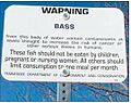
After these studies, a special health warning was given. This warning applies to the Big Sandy River and its bay on the Tennessee River. It says that Largemouth bass and spotted bass in these waters might have mercury in them.
Who Should Be Careful?
- Children
- People who are expecting a baby
- Mothers who are breastfeeding
These groups should not eat Largemouth bass or spotted bass from the Big Sandy River at all. Other people should eat these types of bass only once a month. Mercury can be harmful, especially for growing children.
How Mercury Gets into Fish
Mercury gets into the muscle of fish, not their fat. Larger fish that eat other fish can have more mercury. This is because mercury builds up as it moves up the food chain. This process is called biomagnification.
Imagine tiny plants and animals in the water get a little mercury. Then, small fish eat them. The small fish get more mercury. Then, bigger fish like bass eat the small fish. The bass get even more mercury. So, the mercury level gets stronger at each step up the food chain.
Which Fish Are Safe?
The good news is that other fish in the Big Sandy River were found to be safe to eat. These include:
- Crappie
- Bluegill
- Redear sunfish (also called "shellcrackers")
- Catfish
After the first warning, people asked about another area. This was the backwater area of West Sandy Creek near Springville, Tennessee. The TDEC tested fish there too. They found that bass and crappie in this area, known as the Springville Bottom, also had high levels of mercury.
Images for kids
-
TWRA Contaminant Advisory
