
Kentucky Dam facts for kids
Quick facts for kids Kentucky Dam |
|
|---|---|

|
|
| Official name | Kentucky Dam |
| Location | Livingston County and Marshall County, Kentucky, United States |
| Coordinates | 37°00′47″N 88°16′09″W / 37.01306°N 88.26917°W |
| Construction began | May 1, 1938 |
| Opening date | August 30, 1944 |
| Operator(s) | Tennessee Valley Authority |
| Dam and spillways | |
| Impounds | Tennessee River |
| Height | 206 ft (63 m) |
| Length | 8,422 ft (2,567 m) |
| Reservoir | |
| Creates | Kentucky Lake |


The Kentucky Dam is a huge hydroelectric dam on the Tennessee River in Kentucky. It sits on the border between Livingston and Marshall counties. This dam is the lowest of nine dams on the river. The Tennessee Valley Authority (TVA) built and operates it.
The TVA built the dam in the late 1930s and early 1940s. Its main goals were to make it easier for boats to travel on the lower Tennessee River and to help stop floods on the lower Ohio River and Mississippi River. It was a big project started during the New Deal. This was a plan by President Franklin D. Roosevelt's government to build important things for the country.
The dam creates Kentucky Lake, which covers 160,000 acres (65,000 ha). This is the biggest lake made by the TVA. It is also the largest artificial lake by area in the eastern United States. Kentucky Dam was added to the National Register of Historic Places in 2017.
A special canal connects Kentucky Lake to nearby Lake Barkley. Lake Barkley was made by the Barkley Dam on the Cumberland River. These two lakes run side-by-side for over 50 miles (80 km). The Land Between the Lakes National Recreation Area is located right between them.
Where is Kentucky Dam?
Kentucky Dam is located about 22 miles (35 km) upstream from where the Tennessee River flows into the Ohio River. This meeting point is near Paducah, Kentucky. After the Tennessee River joins it, the Ohio River flows for another 46 miles (74 km). Then, it empties into the Mississippi River near Cairo, Illinois.
The dam is about 20 miles (32 km) north of the Kentucky-Tennessee border. It is also about 10 miles (16 km) southeast of the Kentucky-Illinois border. The town of Grand Rivers is southeast of the dam. Gilbertsville and Calvert City are right downstream.
Kentucky Lake stretches south for 184 miles (296 km). It goes across Kentucky and most of Tennessee. It ends near the Pickwick Landing Dam, close to the Tennessee-Alabama line.
The Barkley Dam is operated by the United States Army Corps of Engineers. It is located on the Cumberland River, a few miles east of Kentucky Dam. The canal that connects Kentucky and Barkley lakes joins Kentucky Lake about 3 miles (4.8 km) upstream from Kentucky Dam.
Dam Size and Power
Kentucky Dam is 206 feet (63 m) tall. More than half of this height is underwater. At 8,422 feet (2,567 m) long, it is the longest dam on the Tennessee River. It is also the longest dam in the entire TVA system.
The dam can produce 223,100 kilowatts of electricity. It has 24 spillway gates that can release a lot of water. Kentucky Lake has 2,064 miles (3,322 km) of shoreline and 160,300 acres (64,900 ha) of water. It can also store a huge amount of water to prevent floods. These numbers are the biggest for any lake in the TVA system.
Kentucky Dam also has a large navigation lock for boats. This lock is 600 by 110 feet (183 by 34 m). A new, even bigger lock is being built. It will be 1,200 by 110 feet (366 by 34 m). This new lock will help larger groups of barges travel on the river. Many chemical plants have grown up near Calvert City, below the dam. They benefit from easy barge transport and cheap electricity from the TVA. The locks can raise or lower boats up to 75 feet (23 m) between Kentucky Lake and the river below.
Building the Dam

For many years, people wanted to make it easier for boats to travel on the Tennessee River. By the late 1800s, a 5-foot (1.5 m) deep channel was made, but it wasn't enough for big river traffic. In the 1930s, the Tennessee Valley Authority (TVA) wanted to create a 9-foot (2.7 m) deep channel along the entire river. This would go from Paducah all the way to Knoxville.
The TVA also wanted to help control floods on the lower Mississippi River. A big flood in 1937 on the Ohio River showed how important this was. Studies found that 4% of the water in the lower Mississippi River comes from the Tennessee River area. The TVA looked at different places for the dam and chose the current spot. Congress approved the Kentucky Dam project on May 23, 1938. Construction began on July 1, 1938.

Building Kentucky Dam and its lake was a huge job. It required buying 320,244 acres (129,598 ha) of land. Many families (2,609 of them) had to move. Over 3,390 graves were relocated. Also, 365 miles (587 km) of roads had to be moved. They built 65 new bridges, rebuilt 7, and tore down 3. The Illinois Central Railroad, which had a bridge downstream, was rerouted to go over the top of the dam. Some towns, like Johnsonville and Springville in Tennessee, and Birmingham in Kentucky, were completely covered by the new lake.
Kentucky Dam was finished and its gates closed on August 30, 1944. The first generator started making electricity on September 14, 1944. This project cost almost $118 million, making it the most expensive TVA dam at the time. The navigation lock at Kentucky Dam was the first one designed by the TVA itself.
Kentucky Dam is built to be very strong. It is in the New Madrid Seismic Zone, an area where big earthquakes have happened before. This means the dam was designed to handle strong earthquake shaking. Experts have said the dam is well-maintained and safe.
The dam used to carry a railroad line and two lanes of US 62/641 on its top. But because of the new, larger lock being built, two new bridges were constructed just downstream. These new bridges opened in late 2009. The road on top of the dam is still used for local traffic going to the dam's powerhouse and visitor center, but it no longer crosses the entire river.
Images for kids
-
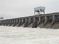
Kentucky Dam, with gates open
-

Construction of the dam
-
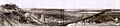
Construction of the dam
-

Kentucky Dam 10-25-1939 Gilbertsville, Kentucky
-
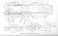
The original design plan for Kentucky Dam, circa 1938
-

Aerial view of Kentucky Dam's lock
