
Land Between the Lakes National Recreation Area facts for kids
Quick facts for kids Land Between the Lakes National Recreation Area |
|
|---|---|

Satellite photography
|
|

Land Between the Lakes National Recreation Area
Location in Kentucky

Land Between the Lakes National Recreation Area
Location in Tennessee

Land Between the Lakes National Recreation Area
Location in the United States
|
|
| Location | Lyon and Trigg counties in Kentucky and Stewart County in Tennessee, USA |
| Nearest city | Murray, Kentucky |
| Area | 171,280 acres (688 km2) |
| Established | 1963 |
| Governing body | United States Forest Service |
| Website | Land Between the Lakes National Recreation Area |


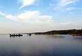
The Land Between the Lakes National Recreation Area is a special outdoor area in the United States. It is located in Kentucky and Tennessee. This area sits between two large lakes: Lake Barkley and Kentucky Lake.
In 1963, President John F. Kennedy officially named it a national recreation area. At first, the Tennessee Valley Authority (TVA) managed the area. The TVA is a government agency that built dams to create these lakes. Later, the United States Forest Service took over its management.
Contents
Discovering the Land Between the Lakes
This unique area is found where the Tennessee and Cumberland rivers flow very close together. This is in the northwestern part of Middle Tennessee and Western Kentucky. A narrow piece of land separates these two rivers. People have called this area "Between the Rivers" for a long time.
In the 1960s, a dam was built on the Cumberland River. A canal was also dug to connect the two large, man-made lakes. Because of this, the Land Between the Lakes became the biggest inland peninsula in the United States. A peninsula is land almost surrounded by water.
A Look Back at the Area's History
During the American Civil War, the Confederate army built Fort Henry here. This fort was on the Tennessee River. Its goal was to protect the river from Union gunboats. After Union forces captured Fort Henry in 1862, there wasn't much more fighting in this specific area.
Creating the Lakes and Recreation Area
In the 1930s, during the Great Depression, President Franklin D. Roosevelt started the New Deal. As part of this, the Tennessee Valley Authority (TVA) was created. The TVA built dams to control floods and make electricity. This project also gave many people jobs.
One of the dams was built on the Tennessee River near Gilbertsville, Kentucky. This dam created Kentucky Lake in the early 1940s. Building this lake meant that some low-lying land would be flooded. About 800 families had to move from their homes. Entire towns, like Birmingham, Kentucky, are now underwater. Some people were upset about moving, while others were happy to start fresh elsewhere.
The plan was to turn the entire "Between the Rivers" area into the Land Between the Lakes National Recreation Area. This meant the land would be used for many types of fun activities.
The United States Army Corps of Engineers built another dam on the Cumberland River. This created Lake Barkley in the 1960s. This lake was named after Alben W. Barkley, who was a Vice President from Kentucky. A canal was also built to connect Lake Barkley and Kentucky Lake. This made it easier for boats to travel between the rivers.
Fun Attractions and Wildlife
Unlike a national park, the Land Between the Lakes allows hunting in certain areas. Plans for the recreation area included special attractions. One was a bison range, as these large animals used to live here. Another was "The Homeplace," a farm rebuilt to look like it did in the 1850s. Staff in old-fashioned clothes show visitors what farm life was like back then. Both of these attractions opened in the 1970s.
The main road through the Tennessee part of the area was renamed "The Trace." This name comes from "Buffalo Trace," which were paths used by bison and later by Native Americans and settlers.
The creation of the recreation area meant that some towns, like Tharpe, Tennessee; Model, Tennessee; and Golden Pond, Kentucky, were abandoned. Today, the headquarters of the recreation area is located where Golden Pond used to be. Here, you can find a museum, a planetarium, and an area for learning about the environment.
The recreation area has many miles of hiking trails. There are also places to launch boats, an area for off-road vehicles, and many campgrounds. Most of these attractions require a small fee to use.
Elk and Bison Prairie

In the 1970s, a 700-acre area called the "Elk & Bison Prairie" was created. To prepare the land, the TVA used controlled burns. This helped native prairie grasses grow again, which had been taken over by oak and hickory trees. After the area was burned and reseeded, elk and American bison were brought in. Their grazing helps keep the trees from growing too much.
The "Elk & Bison Prairie" officially opened in 1996. Visitors can drive through it and see these large animals. They show what the landscape might have looked like in the 1700s.
In 1998, the United States Congress decided that the United States Forest Service would manage the Land Between the Lakes. This agency is part of the United States Department of Agriculture.
Images for kids
-
Land Between The Lakes National Recreation Area
.jpg)
