Dyer County, Tennessee facts for kids
Quick facts for kids
Dyer County
|
|
|---|---|

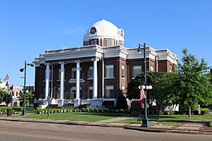
Dyer County Courthouse in Dyersburg in 2022
|
|

Location within the U.S. state of Tennessee
|
|
 Tennessee's location within the U.S. |
|
| Country | |
| State | |
| Founded | 1823 |
| Named for | Robert Henry Dyer, state legislator |
| Seat | Dyersburg |
| Largest city | Dyersburg |
| Area | |
| • Total | 527 sq mi (1,360 km2) |
| • Land | 512 sq mi (1,330 km2) |
| • Water | 14 sq mi (40 km2) 2.7%% |
| Population
(2020)
|
|
| • Total | 36,801 |
| • Density | 75/sq mi (29/km2) |
| Time zone | UTC−6 (Central) |
| • Summer (DST) | UTC−5 (CDT) |
| Congressional district | 8th |
Dyer County is a county in the western part of Tennessee, a state in the United States. In 2020, about 36,801 people lived here. The main town and county seat is Dyersburg. Dyer County is also part of the Dyersburg, TN Micropolitan Statistical Area, which is a small city area.
Contents
History of Dyer County
Dyer County was officially created on October 16, 1823. This happened through a special law passed by Tennessee. Before this, the land was used by the Chickasaw Native American people.
The county was named after Robert Henry Dyer (who lived from about 1774 to 1826). He was an army officer who fought in several wars. These included the Creek War, the War of 1812, and the First Seminole War. Later, he became a state senator. He helped create both Dyer County and Madison County, Tennessee.
On April 2, 2006, strong storms hit Dyer County. These storms caused tornadoes. Sadly, 16 people in the county and 24 people in Tennessee lost their lives.
Geography of Dyer County
The U.S. Census Bureau says Dyer County covers about 527 square miles. Most of this (512 square miles) is land, and 14 square miles (about 2.7%) is water.
The Mississippi River flows along the western edge of the county. This river forms its border. The county is in a flat area of Tennessee called the "Mississippi bottomland."
U.S. Route 51 goes right through Dyer County. This is an old, important highway. It connects Memphis in the south to Chicago in the north. This road will eventually become Interstate 69, a major highway. To the west, Interstate 155 connects Dyer County to Missouri. This highway crosses the Mississippi River. It is one of the few ways to drive between Tennessee and states west of the river, besides the roads near Memphis.
Neighboring Counties
- Lake County (north)
- Obion County (northeast)
- Gibson County (east)
- Crockett County (southeast)
- Lauderdale County (south)
- Mississippi County, Arkansas (southwest)
- Pemiscot County, Missouri (northwest)
Protected Natural Areas
- Bogota Wildlife Management Area
- Moss Island Wildlife Management Area
- Ernest Rice Wildlife Management Area
- Thorny Cypress Wildlife Management Area
- Tigrett Wildlife Management Area (part)
- Tumbleweed Wildlife Management Area (part)
- White Lake Refuge
Main Roads
 I-155
I-155 US 51
US 51 US 412
 SR 78
SR 78 SR 104
 SR 210
 SR 211
Population of Dyer County
| Historical population | |||
|---|---|---|---|
| Census | Pop. | %± | |
| 1830 | 1,904 | — | |
| 1840 | 4,484 | 135.5% | |
| 1850 | 6,361 | 41.9% | |
| 1860 | 10,536 | 65.6% | |
| 1870 | 13,706 | 30.1% | |
| 1880 | 15,118 | 10.3% | |
| 1890 | 19,878 | 31.5% | |
| 1900 | 23,776 | 19.6% | |
| 1910 | 27,721 | 16.6% | |
| 1920 | 29,983 | 8.2% | |
| 1930 | 31,405 | 4.7% | |
| 1940 | 34,920 | 11.2% | |
| 1950 | 33,473 | −4.1% | |
| 1960 | 29,537 | −11.8% | |
| 1970 | 30,427 | 3.0% | |
| 1980 | 34,663 | 13.9% | |
| 1990 | 34,854 | 0.6% | |
| 2000 | 37,279 | 7.0% | |
| 2010 | 38,335 | 2.8% | |
| 2020 | 36,801 | −4.0% | |
| U.S. Decennial Census 1790–1960 1900–1990 1990–2000 2010–2014 |
|||
2020 Census Information
In 2020 United States census, there were 36,801 people living in Dyer County. These people lived in 15,120 households. About 10,566 of these were families.
| Race | Number of People | Percentage |
|---|---|---|
| White (not Hispanic) | 28,272 | 76.82% |
| Black or African American (not Hispanic) | 5,335 | 14.5% |
| Native American | 81 | 0.22% |
| Asian | 213 | 0.58% |
| Pacific Islander | 11 | 0.03% |
| Other/Mixed Race | 1,586 | 4.31% |
| Hispanic or Latino | 1,303 | 3.54% |
Education in Dyer County
Dyer County has several places for learning:
- Dyersburg State Community College - This college opened in 1969.
- Tennessee College of Applied Technology - Northwest - This school is in Newbern and started in 1965. It teaches job skills.
There are also two school districts for students from kindergarten to 12th grade:
- Dyer County School District
- Dyersburg City School District
Media in Dyer County
Newspapers
The State Gazette newspaper comes out three times a week. It covers general news for Dyersburg and Northwest Tennessee. This paper has been serving the area since 1865.
Radio
Burks Broadcasting operates several radio stations: 100 Jack-FM, Eagle 97.3, and WTRO.
Transportation in Dyer County
Major Highways
Interstate 155 (Missouri–Tennessee) connects Dyersburg and nearby towns like Lenox and Big Boy Junction to Missouri. It crosses the Mississippi River over the Caruthersville Bridge. This is also how U.S. Route 412 enters Tennessee from Missouri.
Tennessee State Route 78 links Dyersburg with Nauvoo and Bogota. It then goes north into Lake County. U.S. Route 51 cuts through Dyer County. It connects towns like Trimble, Newbern, Dyersburg, Fowlkes, and Bonicord. This highway goes north to Obion County and south to Lauderdale County. In Dyersburg, there's a bypass road built in the 1970s. It helps traffic go around the busy downtown area.
Railroads
The Canadian National Railway's Gulf Division line runs through Trimble, Newbern, and Dyersburg. It connects to Memphis in the south. It also links to the larger CN rail network in the north. The TennKen Railroad connects Dyersburg to western parts of the county, like Lenox and Miston. It also goes through Lake County and ends in Hickman, Kentucky, on the Mississippi River.
Dyer County has one of only two active passenger train stations in Tennessee. The other is in Memphis. Amtrak's train, the City of New Orleans, stops at the historic Illinois Central Railroad depot in Newbern twice a day.
Communities in Dyer County
Cities
Dyersburg (county seat)
- Bruce
- Edinburgh
- Gardner Heights
- Lakewood
- Lattawoods
- Milltown
- Pioneer
- Southtown
- The Farms
- Twin Oaks
- Pill Hill
Towns
Newbern
- Crowne Point
- Flower Valley
- Oakview
Small Unincorporated Communities
Notable People
- Emmet Kelly - An American clown born in Dyersburg in 1898.
- Noah Lewis - An American Blues musician who worked in Minglewood in the 1920s.
- Julius Morgan - The first person to be executed by electric chair in Tennessee.
See also
 In Spanish: Condado de Dyer para niños
 | Misty Copeland |
 | Raven Wilkinson |
 | Debra Austin |
 | Aesha Ash |


