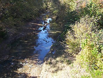
Nonconnah Creek facts for kids
Quick facts for kids Nonconnah Creek |
|
|---|---|

Nonconnah Creek in 2008
|
|
| Country | United States |
| State | Tennessee |
| Physical characteristics | |
| Main source | Shelby County, Tennessee |
| River mouth | McKellar Lake 200 ft (61 m) |
| Length | 29.7 mi (47.8 km) |
Nonconnah Creek is a waterway in southwest Tennessee. It's about 29.7 miles (47.8 km) long. This creek starts in southeastern Shelby County, Tennessee, near Collierville. It then flows west, creating the southern edge of Germantown. The creek continues through Memphis and Whitehaven. Finally, Nonconnah Creek flows into McKellar Lake. This lake is an oxbow lake, which means it used to be part of the Mississippi River.
Three major highways follow much of the creek's path. These are Interstate 55, Interstate 240, and Tennessee State Route 385. Route 385 used to be called "Nonconnah Parkway."
Contents
History of Nonconnah Creek
Nonconnah Creek was formed around 12,000 years ago. It was created by water melting from huge glaciers.
How the Creek's Path Changed
Before about the year 400 AD, the creek flowed differently. It went northwest from where it started. Then, it crossed what is now East Memphis and Midtown. It joined the Wolf River before that river met the Mississippi River.
Around 400 AD, a big earthquake happened. This earthquake was part of the New Madrid Fault system. It caused a low ridge to rise across East Memphis. This ridge changed the creek's path. Nonconnah Creek then flowed directly into the Mississippi River. This new meeting point was several miles south of where the Wolf River joined. The lowest part of Nonconnah Creek that still flowed into the Wolf River became known as Cypress Creek.
Widening the Creek
In the 1900s, Nonconnah Creek was made wider and straighter. This was done from its mouth all the way to near Houston Levee Road in Collierville. Many other rivers in West Tennessee were also changed this way.
What Does "Nonconnah" Mean?
The name Nonconnah comes from either the Choctaw language or the Chickasaw language. It is thought to mean "seer" or "prophet."
Nonconnah Creek's Watershed
The Nonconnah Creek watershed is the area of land where all the water drains into the creek. This watershed covers parts of two counties in Tennessee: Shelby and Fayette. It also includes parts of two counties in Mississippi: Marshall and DeSoto.
The creek's watershed drains about half of the city of Memphis. The other half of Memphis is drained by the Wolf River.
Major Flooding Events
Nonconnah Creek has experienced several big floods over the years.
Past Floods and Rainfall
- On November 21, 1934, a lot of rain fell. About 10.48 inches (26.6 cm) of rain came down in just 24 hours.
- On May 9, 1958, about 4.76 inches (12.1 cm) of rain fell in about eight hours.
- The most recent major flood was on December 3, 1978. About 4.9 inches (12.4 cm) of rain were recorded at the Memphis International Airport. This 1978 storm was considered a "5-year to 10-year frequency event." This means a storm of that size is expected to happen every 5 to 10 years.
Impact of Urbanization
If floods like those in 1934 and 1958 happened today, they would cause much more damage. This is because more buildings and roads have been built in the area. This process is called urbanization.
Backwater Flooding Explained
Sometimes, the Mississippi River gets very high. If it rises above 40 feet (12.2 meters) on the Memphis river gauge, Nonconnah Creek can experience "backwater flooding."
How Backwater Flooding Happens
Backwater flooding means that the creek starts to flow backward. This happens because the rising Mississippi River pushes water into the smaller streams and rivers connected to it. The creek fills up with water from the Mississippi.
This type of flooding happened during the big Mississippi River floods in 1927 and 1937.
Levees and Protection
In the 1940s, the U.S. Army Corps of Engineers built a system of earthen walls called levees. These levees are along the northern side of Nonconnah Creek. They stretch from the creek's mouth to Prospect Street in South Memphis.
During the 2011 Mississippi River floods, these levees helped protect the northern side of the creek. However, the south side still had backwater flooding. This caused damage to several neighborhoods. The creek also flowed backward within its channel all the way to the Lamar Avenue (U.S. Route 78) overpass.
Nonconnah Greenbelt Project
The Nonconnah Greenbelt is a plan for a system of trails. These trails are being planned and built along the creek. If completed, the greenbelt would stretch from Collierville all the way to the Mississippi River.
The first part of the project, called Phase I, was finished in late 2007. It is located near Collierville, close to the intersection of TN 385 and Forest Hill Irene Road.

