Loosahatchie River facts for kids
Quick facts for kids Loosahatchie River |
|
|---|---|

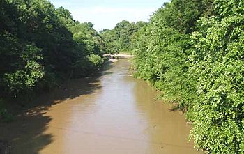
The Loosahatchie River at Arlington, Tennessee
|
|
| Country | United States |
| State | Tennessee |
| Physical characteristics | |
| Main source | Hardeman County, Tennessee 207 ft (63 m) |
| River mouth | Mississippi River |
| Length | 64 mi (103 km) |
The Loosahatchie River is a 64-mile (103 km) long stream in southwestern Tennessee. Most of this river and its main smaller streams have been changed by people. This was done to help with agriculture. The area around the river used to have many cotton farms. Now, more cities and towns have grown there.
Contents
Where Does the Loosahatchie River Start and End?
The Loosahatchie River begins in the western part of Hardeman County, Tennessee. It flows mostly from east to west.
Journey Through Tennessee Counties
The river enters Fayette County, Tennessee. It flows through the town of Somerville. West of Somerville, Interstate 40 crosses the river. This part is one of the few places where the river still flows naturally. After this, the river flows into Shelby County.
Meeting the Mississippi River
The Loosahatchie River ends slightly north of Frayser, a Memphis suburb. It joins the mighty Mississippi River. This meeting point is north of where the Wolf River also joins the Mississippi, near Mud Island. A sandbar in the Mississippi River, called the Loosahatchie Bar, is named after this river.
What Does "Loosahatchie" Mean?
The name "Loosahatchie River" actually means "River River." This is because the word "hatchie" means "river" in several Muskogean languages. These languages were spoken by Native American tribes in the Southeast.
 | Delilah Pierce |
 | Gordon Parks |
 | Augusta Savage |
 | Charles Ethan Porter |

