
Fishers Island, New York facts for kids
Quick facts for kids
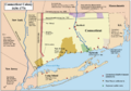
Fishers Island, New York
Munnawtawkit
|
|
|---|---|

Fishers Island with the coast of Groton, Connecticut in the background.
|
|
 |
|
 |
|
| Country | United States |
| State | New York |
| County | Suffolk |
| Town | Southold |
| Area | |
| • Total | 4.97 sq mi (12.86 km2) |
| • Land | 4.06 sq mi (10.50 km2) |
| • Water | 0.91 sq mi (2.36 km2) |
| Elevation | 16 ft (5 m) |
| Population
(2020)
|
|
| • Total | 424 |
| • Density | 104.54/sq mi (40.36/km2) |
| Time zone | UTC−5 (Eastern (EST)) |
| • Summer (DST) | UTC−4 (EDT) |
| ZIP Code |
06390 (originally 11943)
|
| Area code(s) | 631 |
| FIPS code | 36-25923 |
| GNIS feature ID | 950166 (populated place) 950165 (island) |
Fishers Island (which the Pequot Indians called Munnawtawkit) is an island that is part of Southold, New York. It's located at the eastern end of Long Island Sound. The island is about 2 miles (3.2 km) off the coast of Connecticut.
Fishers Island is about 9 miles (14.5 km) long and 1 mile (1.6 km) wide. It's about 11 miles (17.7 km) from the tip of Long Island. You can reach the island from New London, Connecticut, by plane or ferry.
The island is part of the town of Southold in Suffolk County. It's a special area called a census-designated place (CDP). In 2010, about 236 people lived there all year. But in the summer, the population can grow to about 2,000 people!
Contents
History of Fishers Island
The Pequot Indians first called the island Munnawtawkit. In 1614, a European explorer named Adriaen Block visited the island. He named it Vischer's Island after one of his friends. For the next 25 years, it was mostly wild land. Dutch traders sometimes visited it.
John Winthrop the Younger received permission to own Fishers Island in 1640. This permission came from the Massachusetts Bay Colony. He also asked the Connecticut General Court for a similar grant. This was to make sure his ownership was clear.
Winthrop lived on the island for one winter. He later became the governor of the Connecticut Colony. He used the island to raise sheep for food and wool. After he died in 1676, his son Fitz-John hired a farmer named William Walworth. Walworth started farming the island, turning forests into farmland. He and his family left after nine years because of pirates.
The Winthrop family owned Fishers Island until 1863. Then, it was sold to Robert R. Fox. Later, it was sold to Edmund and Walton Ferguson. They were also from Connecticut.
Border Disputes
Fishers Island was part of a disagreement between New York and Connecticut. The states of New York, Connecticut, and Rhode Island meet in the waters east of the island. When the British took over New York City in 1664, they claimed all of Suffolk County. This included Fishers Island.
Settlers in Suffolk County wanted to stay under Connecticut's rule. But the governor, Sir Edmund Andros, made them agree to New York's control by 1676. In 1879, a group from Connecticut and New York agreed that Fishers Island legally belonged to New York.
Revolutionary War and Development
During the American Revolutionary War, British soldiers raided islands in Long Island Sound. They were looking for supplies. Many Fishers Island residents moved their animals to Connecticut for safety in 1776. But the raids continued, and the British burned many homes in 1779.
In 1783, people started making bricks on the island. They used the large amounts of clay found there. This business stopped in 1889. In 1870, a lifesaving station was built on the west end of the island. It helped boats in trouble. The Race Rock Light was built in 1878 to help ships navigate. A permanent United States Coast Guard station was built in the early 1900s.
In 1898, the federal government bought land on the western end of the island. They built Fort H.G. Wright there. This fort was part of a big project to defend the coast. It was mostly left empty after World War II. The fort brought many people to the island. In the 1890s, more summer visitors came, and the Fishers Island Yacht Club was built.
Island Utilities and Storms
A company called E.W. & W. Ferguson managed the island's hotel, ferry, and utilities. It was later renamed Fishers Island Farms, then Fishers Island Utility Company. Today, this company still provides water, telephone, and electricity. The ferry is run by the Fishers Island Ferry District. This is a public group that uses special taxes. The town also manages the Elizabeth Field airport.
Hurricanes have greatly affected the island. The Great September Gale of 1815 destroyed almost all the trees. It also caused a huge storm surge that flooded coastal towns. The island looked like Ireland for many years, with stone walls and few trees.
The New England Hurricane of 1938 brought new seeds to the island. This helped the trees grow back. The damage from this storm was not as bad as in 1815. Only a few homes were destroyed, mainly by wind.
Geography and Climate
Fishers Island is about 10.9 square kilometers (4.2 square miles) in total area. Most of this is land, with a small amount of water.
The island was formed by a terminal moraine. This is a ridge of rocks and dirt left behind by a glacier. It's like the same ridge that formed the North Fork of Long Island. Fishers Island is basically a long pile of rocky material. This material was scraped from the surface of southern Connecticut by a glacier.
Island Climate
Fishers Island's weather is affected by the nearby Long Island Sound and the ocean. The winds usually blow from the sea. The climate here is called "oceanic." This means the ocean keeps the island warmer in the fall and winter.
Even though summer days can be hot, temperatures on Fishers Island are usually lower than on the mainland. For example, in July and August, the average daytime temperature is usually in the mid- to upper 70s Fahrenheit (21-26 Celsius). This is cooler than nearby areas of New England.
Island Population
| Historical population | |||
|---|---|---|---|
| Census | Pop. | %± | |
| 2000 | 289 | — | |
| 2010 | 236 | −18.3% | |
| 2020 | 424 | 79.7% | |
| U.S. Decennial Census | |||
In 2000, there were 289 people living on Fishers Island. By 2020, the population grew to 424 people. Many people who live on the island year-round also have homes in Connecticut.
The population changes a lot throughout the year. It's much smaller in the winter. But in the summer, many visitors come to the island. This makes the population much larger.
Arts and Culture
Fishers Island feels more connected to Connecticut than to the rest of New York. Connecticut is only 2 miles (3.2 km) north of the island. The connection to New York State is mainly political, not emotional. The island looks and feels like a New England community.
The island's ZIP code is 06390. This ZIP code starts with "06," which is used for Connecticut ZIP codes. Other New York State ZIP codes start with "1." This change was made to make mail delivery easier. Fishers Island is closer to Connecticut than to Long Island.
Telephone calls from Fishers Island to anywhere else are considered long distance. Even calls to New York City are long distance. If New York state troopers need to go to Fishers Island, they have to travel through Connecticut. Then they take the ferry from New London.
All sports teams at Fishers Island School play against teams from Connecticut. They don't play against any New York teams. The island's trash is sent to Wallingford, Connecticut. Residents also follow Connecticut's recycling laws.
Since the early 1900s, wealthy families have chosen the island for their summer vacations. These include families like the Rockefellers and Roosevelts. Their beautiful homes show a focus on tradition.
Most year-round residents live on the western end of the island. The island has everything needed for small-town life. This includes a K-12 school, a bowling alley, a movie theater, and a grocery store. There are also two gas stations, a volunteer fire department, and a post office. The west end also has a small airport called Elizabeth Field. You can also find a museum, an ice cream shop, and a restaurant-bar.
Fishers Island is also home to the Fishers Island Oyster Farm. This farm sells oysters directly to customers and restaurants.
Parks and Recreation
Fishers Island has several beaches. These include South Beach, Isabella Beach, Chocomount Beach, and Dock Beach. Dock Beach is located at West Harbor.
The Fishers Island Club offers tennis courts, a beachfront, and a clubhouse. It also has a golf course. President Dwight D. Eisenhower once called it a "real course."
Hay Harbor is another club with golf, tennis, swimming, and sailing. The Fishers Island Yacht Club holds races in the summer. They have two racing fleets.
Education
The Fishers Island Union Free School District is located at 19 Greenwood Road. It has one school that teaches students from pre-kindergarten to 12th grade. In 2014, the district spent about $36,811 per student. The school has a small student-teacher ratio. There are about five students for every full-time teacher.
Media
Some scenes from the movie The World According to Garp were filmed on Fishers Island. They were shot around the mansion built by Robert Linderman. Many other movies have also been filmed on the island.
Images for kids
-
Map of the Connecticut, New Haven, and Saybrook colonies
-
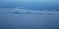
Fishers Island
-
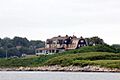
G. B. Linderman Mansion


See also
 In Spanish: Fishers Island para niños
