1938 New England hurricane facts for kids
| Category 5 major hurricane (SSHWS/NWS) | |

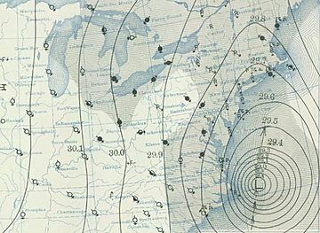
Weather map from September 21, 1938 featuring the storm
|
|
| Formed | September 10, 1938 |
|---|---|
| Dissipated | September 22, 1938 |
| Highest winds | 1-minute sustained: 160 mph (260 km/h) |
| Lowest pressure | 938 mbar (hPa); 27.7 inHg |
| Fatalities | 682 to 800 direct |
| Damage | $306 million (1938 USD) |
| Areas affected | Bahamas, New Jersey, New York, Connecticut, Rhode Island, Massachusetts, Vermont, New Hampshire, Maine, southwestern Quebec |
| Part of the 1938 Atlantic hurricane season | |
The 1938 New England Hurricane was a very powerful and dangerous storm that hit the eastern United States in September 1938. It was an Atlantic tropical cyclone, which is a fancy name for a hurricane. This storm brought strong winds, like a Category 4 hurricane, to places like Long Island, Connecticut, Rhode Island, Massachusetts, Maine, New Hampshire, and Vermont.
Unlike many hurricanes that move out to sea, this one kept going inland. It caused a lot of damage, over $300 million at the time. Sadly, between 682 and 800 people lost their lives because of this storm. Back then, hurricanes weren't given human names like "Katrina" or "Sandy." So, this big storm was simply known by the year it happened.
Images for kids
-
Damage in Island Park, Rhode Island
-
Water levels of the 1815 and 1938 hurricanes are marked at Old Market House, Providence
-
Flooding in Bushnell Park in Hartford, Connecticut in the aftermath of the hurricane; the Travelers Insurance Co. building appears in the back
-
Tobacco barn in Connecticut, 1938, by Sheldon Dick
-
Aerial photo of Marchmont in Winchendon Springs, Massachusetts taken during the summer of 1938.
-
Damage done to pine forests in Wolfeboro, New Hampshire, 1938, by Peter Roome
See also
 In Spanish: Gran Huracán de Nueva Inglaterra de 1938 para niños


