Southold, New York facts for kids
Quick facts for kids
Southold, New York
|
||
|---|---|---|

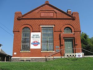
Southold Free Library
|
||
|
||

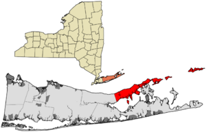
Location in Suffolk County
|
||
| Country | United States | |
| State | New York | |
| County | Suffolk | |
| Government | ||
| • Type | Civil Township | |
| Area | ||
| • Total | 404.04 sq mi (1,046.46 km2) | |
| • Land | 53.75 sq mi (139.21 km2) | |
| • Water | 350.29 sq mi (907.24 km2) | |
| Elevation | 0 ft (0 m) | |
| Population
(2020)
|
||
| • Total | 23,732 | |
| • Density | 441.52/sq mi (170.47/km2) | |
| Time zone | UTC-5 (Eastern (EST)) | |
| • Summer (DST) | UTC-4 (EDT) | |
| ZIP Code |
11971
|
|
| Area code(s) | 631 | |
| FIPS code | 36-69463 | |
| GNIS feature ID | 0979508 | |
The Town of Southold is a town in Suffolk County, New York, United States. It's located on the northeastern tip of Long Island, in an area called the North Fork. In 2020, about 23,732 people lived here. The town also has a smaller area called Southold, which was first settled in 1640.
Contents
History of Southold
Early Native American Life
Before Europeans arrived, Algonquian-speaking tribes lived in eastern Long Island. These tribes were related to those in New England. The western part of Long Island was home to Lenape bands. Their language was also part of the Algonquian languages family.
European Settlements Begin
Dutch colonists built early settlements to the northwest. Fort Orange (now Albany) was founded in 1615. New Amsterdam (now Manhattan) was started in 1625. In 1639, Lion Gardiner created a large estate on Gardiners Island in East Hampton.
Just across from Long Island, the Connecticut Colony was set up in 1636. The Puritans also created the New Haven Colony in 1638. New Haven Colony was a theocracy, meaning only church members could govern.
Founding of Southold
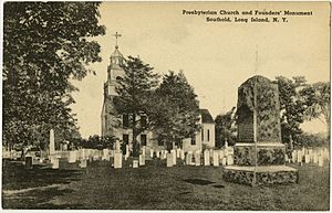
English Puritans from New Haven Colony settled in Southold on October 21, 1640. They bought the land from local Native American groups. These groups were related to the Pequot of New England. They called their land Corchaug, which is now Cutchogue. The settlers wrote the Native American name for Southold as Yennicott.
Many histories say Southold was the first English settlement on Long Island in what would become New York State. Reverend John Youngs led the first families. These families included Barnabas Horton, John Budd, and others.
Dutch and English Control
In 1650, the Treaty of Hartford set a border between Dutch and English lands. This border was roughly through Oyster Bay on the North Shore. The Dutch controlled the western part of Long Island. The English controlled the east. By this time, Southold had about 180 people.
The harbor at Greenport became important for trade, fishing, and whaling. This was because it rarely froze in winter. Settlers also used the land for farming.
Both New Haven Colony and Connecticut Colony wanted Southold to be a theocracy. New Haven Colony did not allow other churches. Connecticut Colony allowed religious freedom. New Haven oversaw Southold until 1662. Then, New Haven towns started to join Connecticut. By 1664, New Haven Colony no longer existed. Southold was part of the Connecticut Colony until 1674.
Becoming Part of New York
When the Dutch took over the colony of New York in 1673, the English towns in the east, like Southold, refused to join them. The Dutch tried to force them, but the towns fought back with help from Connecticut. When the English took New York back in 1674, these eastern towns wanted to stay with Connecticut.
However, James, Duke of York, who owned the colony, forced them to become part of New York. His governor, Sir Edmund Andros, threatened to take away their land rights. So, by 1676, they agreed to join New York. The Duke of York had a reason for this. New Haven had hidden three judges who sentenced his father, King Charles I, to death in 1649.
Growth and Development
Reverend Joshua Hobart became the second minister in Southold in 1674. He was a Harvard graduate. He served the community until he died in 1717 at 88 years old. His brother, Josiah, was an early settler of East Hampton.
The name Southold likely comes from Southwold, a coastal town in Suffolk, England. John Youngs, one of the town's founders, was born in Southwold, England. An area within Southold is called Reydon Shores. This might be a nod to Reydon, England, which Youngs knew. The name might also mean a "holding" (land) to the south of New Haven.
By 1698, Southold's population grew from 180 in 1650 to 880.
In the late 1800s, the Long Island Rail Road reached Greenport. This made it easy for summer visitors to travel by train. The North Fork's unique light, from water on both sides, drew many artists. One famous artist was William Merritt Chase.
The area was mostly used for potato farming for a long time. In the late 1900s, many farms became vineyards. This area of Long Island now has a well-known wine industry. In 1994, the village of Greenport decided to close its police department. The Southold Town Police now handle law enforcement there.
Geography of Southold
Southold is at the northeastern end of Long Island, New York. It is on a peninsula called the North Fork. This includes Plum Island and Fishers Island. The Long Island Sound separates Southold from Connecticut.
The eastern part of the peninsula, near Orient Point, is north of the Town of Shelter Island. Southold is separated from the South Fork of Long Island by the Great Peconic Bay and Little Peconic Bay. The western end of the town borders the Town of Riverhead. It's about 21 miles from Orient Point to the Riverhead border. Robins Island, a protected natural area, is also part of Southold.
The town covers about 404.1 square miles (1046.46 km2). Of this, 53.8 square miles (139.21 km2) is land. A large part, 350.3 square miles (907.24 km2), is water. Southold has about 163 miles of coastline.
Important places for fish and wildlife in Southold include:
- Mattituck Inlet Wetlands and Beaches
- Fishers Island Beaches
- Pine Islands and Shallows
- Goldsmith Inlet and Beach
- Pipes Cove Creek and Moores Drain
- Dumpling Islands and Flat Hammock
Population and People
| Historical population | |||
|---|---|---|---|
| Census | Pop. | %± | |
| 1790 | 3,219 | — | |
| 1800 | 2,200 | −31.7% | |
| 1810 | 2,613 | 18.8% | |
| 1820 | 2,968 | 13.6% | |
| 1830 | 2,900 | −2.3% | |
| 1840 | 3,907 | 34.7% | |
| 1850 | 4,723 | 20.9% | |
| 1860 | 5,833 | 23.5% | |
| 1870 | 6,715 | 15.1% | |
| 1880 | 7,267 | 8.2% | |
| 1890 | 7,705 | 6.0% | |
| 1900 | 8,301 | 7.7% | |
| 1910 | 10,577 | 27.4% | |
| 1920 | 10,147 | −4.1% | |
| 1930 | 11,669 | 15.0% | |
| 1940 | 12,046 | 3.2% | |
| 1950 | 11,632 | −3.4% | |
| 1960 | 13,295 | 14.3% | |
| 1970 | 16,804 | 26.4% | |
| 1980 | 19,172 | 14.1% | |
| 1990 | 19,836 | 3.5% | |
| 2000 | 20,599 | 3.8% | |
| 2010 | 21,968 | 6.6% | |
| 2020 | 23,732 | 8.0% | |
| U.S. Decennial Census | |||
In 2000, there were 20,599 people living in Southold. There were 8,461 households and 5,804 families. The population density was about 383.5 people per square mile.
Most people (93.53%) were White. About 2.91% were Black or African American. About 4.77% of the population was Hispanic or Latino.
About 26.5% of households had children under 18. Most households (56.8%) were married couples living together. The average household had 2.40 people. The average family had 2.90 people.
The median age in Southold was 45 years old. About 21.5% of the population was under 18. About 23.1% were 65 or older.
The median income for a household was $49,898. For a family, it was $61,108. About 5.8% of the population lived below the poverty line. This included 7.2% of those under 18.
Communities and Places
Southold Town has one village and several hamlets.
Villages
- Greenport: Located near the eastern end of the mainland.
Hamlets
- Cutchogue: In the western part of town, it was originally a farming village.
- East Marion: In the eastern part of the town.
- Fishers Island: A hamlet on Fishers Island.
- Laurel: Near the western town line.
- Mattituck: In the western part of town, settled in 1680.
- New Suffolk: In the southwest part of the town.
- Orient: The eastern tip of the mainland.
- Peconic: In the central part of the town, southwest of Southold village.
- Southold: The main hamlet of Southold, settled in 1640.
Other Communities
- Arshamomaque: Between Greenport and Southold village.
- Bay Haven: On Little Peconic Bay.
- Bay View: On Great Hog Neck.
- Beixedon Estates: A private community east of Southold village.
- Cedar Beach: On Great Hog Neck, southeast of Bay View.
- Corey Creek: A private community on Great Hog Neck.
- Cove, The
- Cutchogue Station: North of Cutchogue.
- Fleet's Neck: South of Cutchogue.
- Founder's Landing: The historic center of Southold Village.
- East Cutchogue: Located east of Cutchogue.
- Eastwind Shores
- Laughing Water: Near Great Hog Neck.
- Nassau Farms
- Nassau Point: On Little Hog Neck.
- Oregon: Along Oregon Road between Mattituck and Peconic.
- Orient Point: At the eastern tip of the mainland.
- Reydon Shores: On Great Hog Neck, named after Reydon in Suffolk, England.
- Stirling: North of Greenport.
- Terry Waters: On Little Peconic Bay.
- Waterville: North of Mattituck.
Culture and Arts
Southold Town, like the rest of the East End, has a rich cultural history. Famous artists have lived here, including Douglas Moore, Robert Berks, and Walt Whitman. The town has many art galleries and studios. These show all kinds of artistic expression.
Southold also has a strong community of musicians. The Green Hill Kitchen, a local music spot, has hosted modern jazz stars. These include Tommy Campbell (musician), Gil Goldstein, Alex Sipiagin, and Morris Goldberg.
Transportation
Trains
- The Long Island Rail Road's Main Line runs through Southold.
- Passengers can travel to New York City from stations in Mattituck, Southold, and Greenport.
- The line is also used by the Railroad Museum of Long Island.
Buses
- Suffolk County Transit buses serve Southold.
- Hampton Jitney buses are also available for trips to New York City.
Main Roads
 New York State Route 25 is the main road going west to east. It is mostly called "Main Road."
 New York State Route 114 connects to Greenport via the ferry to Shelter Island.
 County Route 48 (Suffolk County, New York) is another important road. It runs between Mattituck and north of Greenport.
- Sound Avenue was once part of New York State Route 25A. It is still an important road from Wading River to Mattituck.
Airports
- Mattituck Airport
- Charles Rose Airport
Ferries
- Cross Sound Ferry: Travels from Orient to New London, Connecticut.
- North Ferry: Travels from Greenport to Shelter Island.
See also
 In Spanish: Southold (Nueva York) para niños


