Laurel, New York facts for kids
Quick facts for kids
Laurel, New York
|
|
|---|---|
 |
|
| Country | United States |
| State | New York |
| County | Suffolk |
| Towns | Southold and Riverhead |
| Area | |
| • Total | 3.07 sq mi (7.96 km2) |
| • Land | 3.00 sq mi (7.77 km2) |
| • Water | 0.07 sq mi (0.19 km2) |
| Elevation | 20 ft (6 m) |
| Population
(2020)
|
|
| • Total | 1,495 |
| • Density | 498.33/sq mi (192.41/km2) |
| Time zone | UTC-5 (Eastern (EST)) |
| • Summer (DST) | UTC-4 (EDT) |
| ZIP code |
11948
|
| Area code(s) | 631 |
| FIPS code | 36-41465 |
| GNIS feature ID | 0955082 |
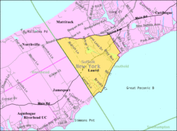
Laurel is a small community in Suffolk County, New York. It is known as a hamlet and a census-designated place (CDP). This means it's a small area with a name, but it's not officially a town or city.
Laurel is mostly located within the Town of Southold. A smaller part of it is in the Town of Riverhead. In 2010, about 1,394 people lived there. By 2020, the population grew to 1,495 people.
History of Laurel
The area where Laurel is now was once called the "Middle Ground." This name came about because it was located between the towns of Southold and Riverhead.
Later, the community was named Franklinville. However, there was another place in New York already called Franklinville. To avoid confusion, the people of this community decided to change its name. They chose the name Laurel, which is still used today.
Geography of Laurel
Laurel covers a total area of about 3.07 square miles (7.96 square kilometers). Most of this area is land. About 3.00 square miles (7.77 square kilometers) is land.
A small part of Laurel is water. This includes about 0.07 square miles (0.19 square kilometers) of water. This means that about 2.39% of Laurel's total area is water.
Who Lives in Laurel?
According to the 2020 census, 1,495 people live in Laurel. Let's look at some details from the 2000 census to understand the community better.
In 2000, there were 1,188 people living in Laurel. These people lived in 452 households. A household is a group of people living together in one home. Out of these, 343 were families.
Most people in Laurel were White (97.05%). A small number were African American (1.26%) or Native American (0.25%). Some people were from other backgrounds or a mix of two or more races. About 2.36% of the population identified as Hispanic or Latino.
Many households (30.5%) had children under 18 living with them. Most households (64.4%) were married couples living together. About 8.4% of households had a female head without a husband present.
The average household had about 2.61 people. The average family had about 3.03 people.
The population in Laurel was spread out by age.
- About 23.2% were under 18 years old.
- About 6.9% were between 18 and 24 years old.
- About 25.8% were between 25 and 44 years old.
- About 25.0% were between 45 and 64 years old.
- About 19.0% were 65 years or older.
The median age in Laurel was 41 years old. This means half the people were younger than 41 and half were older.
In 2000, the median income for a household in Laurel was $57,639. The median income for a family was $67,000. The average income per person in Laurel was $26,903. A small percentage of families (2.4%) and people (4.0%) lived below the poverty line. This included 3.3% of those under 18 and 2.3% of those 65 or older.
School
Children in Laurel attend schools within the Mattituck-Cutchogue Union Free School District.
See also
 In Spanish: Laurel (Nueva York) para niños
 | Selma Burke |
 | Pauline Powell Burns |
 | Frederick J. Brown |
 | Robert Blackburn |


