
Long Island facts for kids
|
Native name:
Paumanok
|
|
|---|---|

Location of Long Island in New York state
|
|

Long Island
Location in the United States
|
|
| Geography | |
| Location | Atlantic Ocean |
| Coordinates | 40°48′N 73°18′W / 40.8°N 73.3°W |
| Area | 1,376.1 sq mi (3,564 km2) |
| Highest elevation | 401 ft (122.2 m) |
| Highest point | Jayne's Hill |
| Administration | |
| State | New York |
| Largest settlement | Brooklyn, New York City (pop. 2,736,074) |
| Demographics | |
| Demonym | Long Islander |
| Population | 8,063,232 (2020) |
| Pop. density | 5,859.5 /sq mi (2,262.37 /km2) |
| Ethnic groups | 54.7% White, 20.5% Hispanic or Latino of any race, 20.4% Black, 12.3% Asian, 8.8% other races, 3.2% from two or more races, 0.49% Native American, and 0.05% Pacific Islander |

.jpg)

.jpg)


_(16026356533).jpg)
Long Island is a large island located east of Manhattan in southeastern New York state. It's a very important part of the New York metropolitan area, both in terms of how many people live there and its size. The island stretches about 118 miles (190 km) eastward into the Atlantic Ocean. It is about 23 miles (37 km) wide at its widest point. With a land area of about 1,401 square miles (3,629 km²), it is the biggest island in the contiguous United States.
Long Island is divided into four counties. Kings (Brooklyn), Queens, and Nassau counties are in the western part. Suffolk County makes up the eastern two-thirds. In 2020, most New York City residents (58.4%) lived on Long Island, in the areas of Brooklyn and Queens. However, when people locally say "Long Island" or "the Island," they usually mean only Nassau and Suffolk counties.
Long Island is separated from Manhattan and the Bronx by the East River. To the north is Long Island Sound, with Westchester County, New York and Connecticut across it. To the northeast, across Block Island Sound, is Rhode Island. At its southwest end, Brooklyn is separated from Staten Island and New Jersey by Upper New York Bay, The Narrows, and Lower New York Bay.
With over 8 million people in 2020, Long Island has 40% of New York state's total population. It is the most populated island in any U.S. state or territory. It is also the third-most populated island in the Americas and the 18th-most populated island in the world. Its population density is very high, about 5,859.5 people per square mile (2,262.4/km²). If Long Island were its own state, it would be the 13th most populated and the most densely populated state in the U.S.
Long Island is a mix of cultures and people. It has some of the richest neighborhoods in the world near the shorelines. It also has working-class areas in all four counties.
In 2022, the total economic output (gross domestic product) of Kings, Queens, Nassau, and Suffolk counties was about $500 billion. The average household income on the island is over $100,000. The average home price is around $600,000. Many adults (42.6%) have a college degree or higher. Unemployment on Long Island is usually low, staying below 4%.
Long Island is a major center for commercial aviation. It is home to two of the busiest airports in the U.S. and the New York metropolitan area: JFK International Airport and LaGuardia Airport. Both are in Queens. Long Island MacArthur Airport is also on Long Island.
Long Island has nine major bridges and thirteen tunnels connecting Brooklyn and Queens to other parts of New York City. Ferries connect Suffolk County to Connecticut across Long Island Sound. The Long Island Rail Road is the busiest commuter train system in North America.
Many biotechnology companies, engineering firms, and scientific research centers are on Long Island. These include Brookhaven National Laboratory, Cold Spring Harbor Laboratory, and Stony Brook University.
Contents
Exploring Long Island's Past
Early Days and Native Americans

When Europeans first arrived, the Lenape people lived on the western part of Long Island. They spoke a language called Munsee. The eastern part of the island was home to groups like the Pequot and Narragansett.
Giovanni da Verrazzano was the first European to see the Lenape people in 1524. In 1609, English explorer Henry Hudson explored the harbor. Adriaen Block came in 1615 and was the first European to realize that both Manhattan and Long Island were islands.
Native Americans called Long Island Sewanhaka. This name might refer to wampum, which were special shell beads. Dutch maps from the 1650s called it " 't Lange Eylandt" (Long Island). Later, the English called it "Nassau Island" for a time.
First European Settlements

The first European settlers on Long Island came from England and its colonies in New England. Lion Gardiner settled nearby Gardiners Island. The first town on Long Island itself was Southold, founded on October 21, 1640. Southampton was settled the same year. Other towns like Hempstead and East Hampton followed.

While the English settled the eastern part, the Dutch settled the western part. The Dutch founded six towns in what is now Brooklyn starting in 1645. However, in 1664, the English took over the Dutch colony of New Amsterdam, including Long Island.
By 1683, Long Island was divided into three counties: Kings, Queens, and Suffolk.
Long Island in the 1700s and 1800s

During the American Revolutionary War, the British captured Long Island from General George Washington in the Battle of Long Island. Washington's troops barely escaped under a thick fog. Long Island remained under British control until the war ended in 1783.
General Washington used spies on Long Island because it was close to the British headquarters in New York City. The Culper Ring was a group of spies who worked between Setauket and Manhattan. They gave Washington important British secrets.
Many buildings from this time still exist. These include Raynham Hall, the home of spy Robert Townsend, and the Caroline Church in Setauket. The church still has bullet holes from a fight called the Battle of Setauket.


In the 1800s, Long Island was mostly farmland. The Long Island Rail Road (LIRR) started service in 1836. It helped people travel from Brooklyn to other parts of the island. As more bridges and tunnels were built, areas of the island became residential suburbs.
On January 1, 1898, Kings County (Brooklyn) and parts of Queens became part of "The City of Greater New York". The eastern part of Queens County, which was not included, became Nassau County in 1899.
By the end of the 1800s, rich business owners built huge country homes in Nassau County. This area became known as the Gold Coast. This time and place were made famous in books like F. Scott Fitzgerald's The Great Gatsby.
Modern Long Island: 1900s to Today
Charles Lindbergh took off from Roosevelt Field in 1927 for his famous solo flight to Europe. This helped make Long Island an early center for aviation. Other famous pilots also flew from Long Island. During World War II, companies like Grumman built many military aircraft here. Grumman even helped build parts for lunar and space shuttle vehicles.


From the 1920s to the 1940s, Long Island changed from farms to suburbs. Robert Moses designed many parkways (highways) across the island. He also created beaches and state parks. People started building homes along these new roads.
After World War II, more people moved to Long Island, especially to Nassau and western Suffolk counties. New housing developments, like Levittown, were built quickly. This allowed soldiers returning home to buy houses and start families.
Today, Long Island is home to many different ethnic groups. These include people of Irish, Jewish, and Italian backgrounds. More recently, many people from Asia and Latin America have moved here.
In 1985, the Supreme Court of the United States decided that Long Island was not an island for legal reasons. This was because it had so many connections to the mainland.
By the early 2000s, many Long Island towns changed from industrial areas to places for tourism and culture. Brooklyn became a famous cultural center. Villages like Port Jefferson and Patchogue became popular tourist spots.
Long Island's Landscape and Environment

The western part of Long Island includes the New York City boroughs of Brooklyn and Queens. The middle and eastern parts are suburban Nassau and Suffolk counties. When people say "Long Island," they usually mean Nassau and Suffolk counties.

Nassau County is more developed than Suffolk County. It has very wealthy areas, especially along the Gold Coast and in the Five Towns area. The South Shore has white sandy beaches along the Atlantic Ocean.
In its eastern parts, Suffolk County is still somewhat rural. This includes places like Greenport on the North Fork and parts of The Hamptons. The North Fork has become a popular Wine Country region with many vineyards. The South Fork is known for its beach communities, like the Hamptons. The Montauk Point Lighthouse is at the eastern tip of the island. The Long Island Central Pine Barrens is a protected pine forest in eastern Suffolk County.
How Glaciers Shaped Long Island

Long Island was formed by glaciers many thousands of years ago. These huge sheets of ice left behind piles of gravel and rock called moraines. The northern moraine is called the Harbor Hill moraine. The southern moraine, called the Ronkonkoma moraine, runs through the center of Long Island.

When the glaciers melted, they left behind a large, sandy plain to the south of the moraines. This is why the North Shore beaches are rocky, and the South Shore beaches have fine, clear sand. Jayne's Hill, at 401 feet (122 m), is the highest point on Long Island. The glaciers also created lakes like Lake Ronkonkoma and Lake Success.
Beautiful Views Across the Counties
.jpg)

-
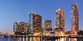
Skyline of Long Island City, Queens
-
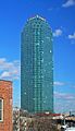
One Court Square. At a height of 658 feet, it is currently Long Island's tallest building.
-
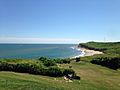
A beach in The Hamptons of Suffolk County


Long Island's Weather and Climate
Long Island has a climate similar to other coastal areas in the Northeastern U.S. It has warm, humid summers and cold, snowy winters. The Atlantic Ocean brings cool breezes in summer, which helps keep temperatures down and reduces thunderstorms. Long Island gets a good amount of sunshine each year.


Winter temperatures are milder than in most of New York state. January is the coldest month, with average temperatures from 30 to 35°F (-1 to 2°C). July is the warmest, with averages from 70 to 80°F (21 to 27°C). Temperatures rarely go below 5°F (-15°C) or above 95°F (35°C). The western part of Long Island is generally warmer due to being closer to the mainland and more developed.
Rainfall is spread evenly throughout the year, with about 3-4 inches (76-102 mm) each month. Average yearly snowfall is about 20 to 35 inches (51-89 cm).

Long Island can be affected by hurricanes. Its northern location and cool waters usually weaken storms before they arrive. However, some strong hurricanes have hit the island. These include the devastating 1938 New England Hurricane and Hurricane Carol in 1954.
In October 2012, Hurricane Sandy caused huge damage to coastal areas. Thousands of homes were destroyed or badly damaged by storm surges. Many residents lost power for weeks. Hurricane Sandy caused an estimated $18 billion in damages in Nassau and Suffolk Counties alone. This storm has led to discussions about building seawalls and other barriers to protect the coast in the future.
| Climate data for Islip, New York (Long Island MacArthur Airport), 1981–2010 normals, extremes 1984–present | |||||||||||||
|---|---|---|---|---|---|---|---|---|---|---|---|---|---|
| Month | Jan | Feb | Mar | Apr | May | Jun | Jul | Aug | Sep | Oct | Nov | Dec | Year |
| Record high °F (°C) | 69 (21) |
67 (19) |
82 (28) |
94 (34) |
98 (37) |
96 (36) |
102 (39) |
100 (38) |
93 (34) |
88 (31) |
78 (26) |
77 (25) |
102 (39) |
| Mean daily maximum °F (°C) | 38.0 (3.3) |
40.3 (4.6) |
47.3 (8.5) |
57.6 (14.2) |
67.5 (19.7) |
76.6 (24.8) |
81.7 (27.6) |
80.4 (26.9) |
73.8 (23.2) |
63.0 (17.2) |
53.2 (11.8) |
43.0 (6.1) |
60.3 (15.7) |
| Mean daily minimum °F (°C) | 23.3 (−4.8) |
25.2 (−3.8) |
31.3 (−0.4) |
40.6 (4.8) |
49.8 (9.9) |
60.2 (15.7) |
66.0 (18.9) |
65.3 (18.5) |
57.5 (14.2) |
45.5 (7.5) |
37.1 (2.8) |
28.2 (−2.1) |
44.3 (6.8) |
| Record low °F (°C) | −7 (−22) |
0 (−18) |
5 (−15) |
23 (−5) |
32 (0) |
42 (6) |
50 (10) |
45 (7) |
38 (3) |
28 (−2) |
11 (−12) |
5 (−15) |
−7 (−22) |
| Average precipitation inches (mm) | 3.64 (92) |
3.26 (83) |
4.44 (113) |
4.34 (110) |
3.78 (96) |
4.27 (108) |
3.43 (87) |
3.98 (101) |
3.58 (91) |
3.79 (96) |
3.67 (93) |
4.06 (103) |
46.24 (1,173) |
| Average snowfall inches (cm) | 6.7 (17) |
7.1 (18) |
4.5 (11) |
0.6 (1.5) |
0 (0) |
0 (0) |
0 (0) |
0 (0) |
0 (0) |
0 (0) |
0.5 (1.3) |
5.4 (14) |
24.8 (62.8) |
| Average precipitation days (≥ 0.01 in) | 11.0 | 9.1 | 10.5 | 11.3 | 11.1 | 10.1 | 9.1 | 8.5 | 8.6 | 8.5 | 10.3 | 10.8 | 118.9 |
| Average snowy days (≥ 0.1 in) | 3.7 | 3.4 | 2.3 | 0.3 | 0 | 0 | 0 | 0 | 0 | 0 | 0.2 | 2.4 | 12.3 |
| Source: NOAA | |||||||||||||
| Climate data for LaGuardia Airport, New York (1981–2010 normals, extremes 1940–present) | |||||||||||||
|---|---|---|---|---|---|---|---|---|---|---|---|---|---|
| Month | Jan | Feb | Mar | Apr | May | Jun | Jul | Aug | Sep | Oct | Nov | Dec | Year |
| Record high °F (°C) | 72 (22) |
74 (23) |
86 (30) |
94 (34) |
97 (36) |
101 (38) |
107 (42) |
104 (40) |
102 (39) |
93 (34) |
83 (28) |
75 (24) |
107 (42) |
| Mean maximum °F (°C) | 58.6 (14.8) |
60.1 (15.6) |
70.5 (21.4) |
81.2 (27.3) |
88.5 (31.4) |
93.4 (34.1) |
96.6 (35.9) |
94.4 (34.7) |
88.8 (31.6) |
79.7 (26.5) |
71.1 (21.7) |
62.1 (16.7) |
98.1 (36.7) |
| Mean daily maximum °F (°C) | 39.3 (4.1) |
42.2 (5.7) |
49.8 (9.9) |
60.9 (16.1) |
71.2 (21.8) |
80.5 (26.9) |
85.3 (29.6) |
83.7 (28.7) |
76.3 (24.6) |
65.2 (18.4) |
54.7 (12.6) |
44.3 (6.8) |
62.9 (17.2) |
| Mean daily minimum °F (°C) | 26.6 (−3.0) |
28.5 (−1.9) |
34.6 (1.4) |
44.4 (6.9) |
53.9 (12.2) |
63.8 (17.7) |
69.5 (20.8) |
68.9 (20.5) |
61.9 (16.6) |
51.0 (10.6) |
41.8 (5.4) |
32.1 (0.1) |
48.2 (9.0) |
| Mean minimum °F (°C) | 10.0 (−12.2) |
13.5 (−10.3) |
19.7 (−6.8) |
33.8 (1.0) |
45.2 (7.3) |
54.1 (12.3) |
62.0 (16.7) |
60.4 (15.8) |
50.9 (10.5) |
39.9 (4.4) |
29.3 (−1.5) |
16.6 (−8.6) |
7.5 (−13.6) |
| Record low °F (°C) | −3 (−19) |
−7 (−22) |
7 (−14) |
22 (−6) |
37 (3) |
46 (8) |
56 (13) |
51 (11) |
41 (5) |
30 (−1) |
17 (−8) |
−2 (−19) |
−7 (−22) |
| Average precipitation inches (mm) | 3.17 (81) |
2.76 (70) |
3.97 (101) |
4.00 (102) |
3.79 (96) |
3.94 (100) |
4.50 (114) |
4.12 (105) |
3.73 (95) |
3.78 (96) |
3.41 (87) |
3.56 (90) |
44.73 (1,136) |
| Average snowfall inches (cm) | 7.4 (19) |
9.1 (23) |
4.4 (11) |
0.5 (1.3) |
0 (0) |
0 (0) |
0 (0) |
0 (0) |
0 (0) |
0 (0) |
0.3 (0.76) |
5.2 (13) |
26.9 (68.06) |
| Average precipitation days (≥ 0.01 inch) | 10.3 | 9.6 | 10.7 | 10.9 | 11.1 | 10.5 | 9.9 | 8.7 | 8.1 | 8.5 | 9.2 | 10.5 | 118.0 |
| Average snowy days (≥ 0.1 inch) | 4.6 | 3.4 | 2.1 | 0.2 | 0 | 0 | 0 | 0 | 0 | 0 | 0.2 | 2.6 | 13.1 |
| Average relative humidity (%) | 61.0 | 60.2 | 59.5 | 59.3 | 63.8 | 64.6 | 64.7 | 67.0 | 67.2 | 65.2 | 64.2 | 63.5 | 63.4 |
| Source: NOAA (relative humidity 1961–1990) | |||||||||||||
| Climate data for JFK Airport, New York (1981–2010 normals, extremes 1948–present) | |||||||||||||
|---|---|---|---|---|---|---|---|---|---|---|---|---|---|
| Month | Jan | Feb | Mar | Apr | May | Jun | Jul | Aug | Sep | Oct | Nov | Dec | Year |
| Record high °F (°C) | 71 (22) |
71 (22) |
85 (29) |
90 (32) |
99 (37) |
99 (37) |
104 (40) |
101 (38) |
98 (37) |
90 (32) |
77 (25) |
75 (24) |
104 (40) |
| Mean maximum °F (°C) | 56.8 (13.8) |
57.9 (14.4) |
68.5 (20.3) |
78.1 (25.6) |
84.9 (29.4) |
92.1 (33.4) |
94.5 (34.7) |
92.7 (33.7) |
87.4 (30.8) |
78.0 (25.6) |
69.1 (20.6) |
60.1 (15.6) |
96.6 (35.9) |
| Mean daily maximum °F (°C) | 39.1 (3.9) |
41.8 (5.4) |
49.0 (9.4) |
59.0 (15.0) |
68.5 (20.3) |
78.0 (25.6) |
83.2 (28.4) |
81.9 (27.7) |
75.3 (24.1) |
64.5 (18.1) |
54.3 (12.4) |
44.0 (6.7) |
61.6 (16.4) |
| Mean daily minimum °F (°C) | 26.3 (−3.2) |
28.1 (−2.2) |
34.2 (1.2) |
43.5 (6.4) |
52.8 (11.6) |
62.8 (17.1) |
68.5 (20.3) |
67.8 (19.9) |
60.8 (16.0) |
49.6 (9.8) |
40.7 (4.8) |
31.5 (−0.3) |
47.3 (8.5) |
| Mean minimum °F (°C) | 9.8 (−12.3) |
13.4 (−10.3) |
19.1 (−7.2) |
32.6 (0.3) |
42.6 (5.9) |
52.7 (11.5) |
60.7 (15.9) |
58.6 (14.8) |
49.2 (9.6) |
37.6 (3.1) |
27.4 (−2.6) |
16.3 (−8.7) |
7.5 (−13.6) |
| Record low °F (°C) | −2 (−19) |
−2 (−19) |
4 (−16) |
20 (−7) |
34 (1) |
45 (7) |
55 (13) |
46 (8) |
40 (4) |
30 (−1) |
19 (−7) |
2 (−17) |
−2 (−19) |
| Average precipitation inches (mm) | 3.16 (80) |
2.59 (66) |
3.78 (96) |
3.87 (98) |
3.94 (100) |
3.86 (98) |
4.08 (104) |
3.68 (93) |
3.50 (89) |
3.62 (92) |
3.30 (84) |
3.39 (86) |
42.77 (1,086) |
| Average snowfall inches (cm) | 6.3 (16) |
8.3 (21) |
3.5 (8.9) |
0.8 (2.0) |
0 (0) |
0 (0) |
0 (0) |
0 (0) |
0 (0) |
0 (0) |
0.2 (0.51) |
4.7 (12) |
23.8 (60) |
| Average precipitation days (≥ 0.01 inch) | 10.5 | 9.6 | 11.0 | 11.4 | 11.5 | 10.7 | 9.4 | 8.7 | 8.1 | 8.5 | 9.4 | 10.6 | 119.4 |
| Average snowy days (≥ 0.1 inch) | 4.6 | 3.4 | 2.3 | 0.3 | 0 | 0 | 0 | 0 | 0 | 0 | 0.2 | 2.8 | 13.6 |
| Average relative humidity (%) | 64.9 | 64.4 | 63.4 | 64.1 | 69.5 | 71.5 | 71.4 | 71.7 | 71.9 | 69.1 | 67.9 | 66.3 | 68.0 |
| Source: NOAA (relative humidity 1961–1990) | |||||||||||||
Nearby Islands to Explore
Several smaller islands are close to Long Island and are often considered part of it. These include Fire Island, a long barrier island along the southern shore. Plum Island is home to a research facility. Other islands include Robins Island, Gardiners Island, Fishers Island, Long Beach Barrier Island, Jones Beach Island, and Shelter Island.
People and Cultures of Long Island
Long Island is the most populated island in the United States. In 2020, the total population of all four counties was over 8 million people. This makes up 40% of New York State's population.
Nassau and Suffolk counties together had almost 3 million people in 2020. Suffolk County is larger in area and has more people now. However, Nassau County is much more densely populated because it is closer to New York City.
White people are the largest racial group in all four counties. Nassau and Suffolk counties have a majority white population. In contrast, Queens is known as the most ethnically diverse county in the United States.
Many different religions are practiced on Long Island. Catholics are the largest religious group. Jewish people are also a significant group.
A large and growing number of Chinese Americans live on Long Island. Expanding Chinatowns are found in Brooklyn and Queens. Chinese immigrants are also moving into Nassau County. Flushing has become home to one of the largest and fastest-growing Chinatowns in the world.
More recently, a Little India community has grown in Hicksville, Nassau County. The Long Island Koreatown also started in Flushing and is spreading eastward into Nassau County.
Long Island is home to two Native American reservations: Poospatuck Reservation and Shinnecock Reservation. Many place names on the island come from Native American languages.
Long Island is known for its affluence. It has some of the wealthiest communities in the U.S. These include The Hamptons on the East End and the Gold Coast.
Long Island's Economy and Innovation


Long Island is a leader in scientific research and engineering. It is home to Brookhaven National Laboratory, which focuses on nuclear physics. The Cold Spring Harbor Laboratory is also here, known for its work in biomedical research.
Many technology companies have made Long Island a center for the computer industry. Stony Brook University and New York Institute of Technology also do advanced medical and technology research.
The Hauppauge Industrial Park is the East Coast's largest industrial park. It has over 1,300 companies and employs more than 71,000 people. About 20% of Long Islanders travel to Manhattan for work.
The eastern part of the island still has farms. Vineyards on the North Fork have created a big wine industry. Pumpkin farms and traditional truck farming are also important. Fishing is a key industry in coastal towns like Huntington and Montauk.
From the 1930s to the 1990s, Long Island was a major center for aerospace manufacturing. Companies like Grumman built aircraft here. While these operations have mostly ended, the Cradle of Aviation Museum shows the island's important role in aviation history.
Learning and Education on Long Island
Schools for Young Learners

Many public and private high schools on Long Island are considered among the best in the U.S. Nassau and Suffolk counties have 125 public school districts with 656 public schools. There are also many private schools and parochial schools.
Brooklyn and Queens are part of the New York City Department of Education, which is the largest school district in the U.S. These boroughs have specialized high schools like Brooklyn Technical High School. They also have private schools and parochial schools.
Colleges and Universities
.jpg)
Long Island has many colleges and universities. The CUNY system has five colleges in Brooklyn and Queens, including Brooklyn College and Queens College. Private colleges like Pratt Institute are also in Brooklyn.
The State University of New York system has campuses on Long Island, such as Stony Brook University, Nassau Community College, and Suffolk County Community College. Other notable private universities include Molloy University, New York Institute of Technology, Hofstra University, and Adelphi University. The United States Merchant Marine Academy, a U.S. service academy, is in Kings Point.
Culture and Fun on Long Island
Music Scene

Music on Long Island is shaped by its closeness to New York City and its suburban youth culture. Mariah Carey, one of the best-selling musicians ever, was born in Huntington. In the 1970s and 80s, Long Island was one of the first places to embrace European New Wave bands.
In the 1990s, hip hop music became popular. Rap pioneers like Rakim and Public Enemy grew up on Long Island. The island was also a big part of the emo music scene in the 2000s, with bands like Brand New and Taking Back Sunday.
Famous rock bands from Long Island include the Ramones (from Queens) and Blue Öyster Cult. Rock and pop singer Billy Joel grew up in Hicksville, and his music often talks about Long Island.
Nassau Coliseum and Jones Beach Theater are popular places for concerts. Jones Beach Theater hosts many summer concerts and a large Fourth of July fireworks show every year.
Long Island is also known for its excellent school music programs. Many students are accepted into statewide and national music groups.
Delicious Food

Long Island has a long history of fishing and seafood. The Blue Point oyster, a very popular type, was first harvested here. Clam digging is also a popular activity, and Manhattan clam chowder is thought to have started on Long Island.

Long Island duck has been famous since the 1800s. Two symbols of this heritage are the Long Island Ducks baseball team and the Big Duck, a historic duck-shaped building. Riverhead also has one of the largest buffalo farms on the East Coast.
Eastern Long Island is a big producer of wines, especially on the North Fork, which has 38 wineries. Many of these have tasting rooms for visitors. Long Island also has many craft beer breweries. The Long Island Iced Tea cocktail is said to have been invented here.
The food on Long Island reflects its diverse population. You'll find many pizzerias and delicatessens across the island.
Sports and Recreation
Major League Sports Teams
_017_-_UBS_Arena.jpg)
The New York Mets baseball team plays at Citi Field in Queens. The Barclays Center in Brooklyn is home to the Brooklyn Nets basketball team and the New York Liberty women's basketball team. The New York Islanders hockey team now plays at UBS Arena in Elmont, New York.
Local Sports Teams


Long Island has its own independent baseball team, the Long Island Ducks, who play at Bethpage Ballpark in Central Islip. The Brooklyn Cyclones are a minor league baseball team linked to the New York Mets. They play at MCU Park in Brooklyn.
Long Island is also a big center for lacrosse. The Long Island Lizards are a professional lacrosse team that plays here.
College Sports
The Stony Brook Seawolves represent Stony Brook University. Their baseball team reached the 2012 College World Series.
Other Fun Sports

Long Island has many golf courses. Two famous ones are Shinnecock Hills Golf Club and the public Bethpage Black Course. Queens hosts the US Open tennis tournament every August. The biggest tennis stadium in the world, Arthur Ashe Stadium, is located there.
Long Island also has two horse racing tracks: Aqueduct Racetrack in Queens and Belmont Park on the Queens/Nassau border. Belmont Park is home to the Belmont Stakes, a famous horse race.
| Club | City | Sport | Founded | League | Venue(s) | Championships |
|---|---|---|---|---|---|---|
| Brooklyn Nets | Brooklyn | Basketball | 1967 | National Basketball Association | Barclays Center | 2 (1974, 1976) |
| New York Islanders | Elmont | Ice hockey | 1972 | National Hockey League | UBS Arena | 4 (1980, 1981, 1982, 1983) |
| New York Mets | Queens | Baseball | 1962 | Major League Baseball | Citi Field | 2 (1969, 1986) |
| Brooklyn Cyclones | Brooklyn | Baseball | 1986 | South Atlantic League | Maimonides Park | 2 (1986, 2001) |
| Long Island Nets | Uniondale | Basketball | 2015 | NBA G League | Nassau Veterans Memorial Coliseum | 0 |
| Long Island Ducks | Islip | Baseball | 2000 | Atlantic League | Fairfield Properties Ballpark | 4 (2004, 2012, 2013, 2019) |
Getting Around Long Island
.jpg)
Long Island has many ways to get around. There are major airports like JFK International Airport and LaGuardia Airport. The Long Island Rail Road and the New York City Subway provide train service. Buses are run by MTA Regional Bus Operations, Nassau Inter-County Express, and Suffolk County Transit. There are also Ferries and several major highways.
There are eleven road crossings from Long Island. Most connect Brooklyn and Queens to Manhattan and the Bronx. The Verrazzano-Narrows Bridge connects Brooklyn to Staten Island.
Public Transportation Options

The Metropolitan Transportation Authority (MTA) runs public transportation for the New York area. This includes all five boroughs of New York City and nearby counties. The MTA is one of the largest public transportation providers in the Western Hemisphere. It serves millions of customers every day.
Trains

The Long Island Rail Road (LIRR) is the busiest commuter train system in North America. It carries hundreds of thousands of passengers each weekday. It is also the oldest railroad in the U.S. that still uses its original name. The LIRR runs all the time, every day of the year. There have been recent projects to add more tracks and expand service.
Buses
_04a.jpg)
Nassau Inter-County Express (NICE) provides bus service in Nassau County. Suffolk County Transit provides bus service in Suffolk County. These bus services help people travel across Long Island.
Driving on Long Island

The Long Island Expressway, Northern State Parkway, and Southern State Parkway are the main highways for driving east-west across the island. These roads were designed by Robert Moses.
| Direction | Route shield |
Name |
|---|---|---|
| West-East | Nassau Expressway northern section | |
| Montauk Highway | ||
| Sunrise Highway* | ||
| Belt Parkway / Southern State Parkway | ||
| Hempstead Turnpike | ||
| Babylon–Farmingdale Turnpike | ||
| Grand Central Parkway / Northern State Parkway | ||
| Long Island Expressway | ||
| Jericho Turnpike/Middle Country Road | ||
| Northern Boulevard | ||
| South-North | Brooklyn-Queens Expressway | |
| Van Wyck Expressway | ||
| Nassau Expressway southern section | ||
| Clearview Expressway | ||
| Cross Island Parkway | ||
| Meadowbrook State Parkway | ||
| Wantagh State Parkway | ||
| Newbridge Road | ||
| Cedar Swamp Road/Broadway/Hicksville
Road |
||
| Seaford-Oyster Bay Expressway | ||
| Broad Hollow Road | ||
| Deer Park Avenue | ||
| Robert Moses Causeway | ||
| Sagtikos State Parkway | ||
| Sunken Meadow State Parkway | ||
| Islip Avenue | ||
| Nicolls Road | ||
| William Floyd Parkway | ||
|
Roads in boldface are limited access roads. |
||
Famous People from Long Island
See also
 In Spanish: Long Island para niños
