Islip, New York facts for kids
Quick facts for kids
Islip, New York
|
|||
|---|---|---|---|
| Town of Islip | |||
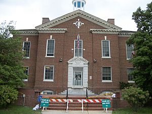
Islip Town Hall in 2012.
|
|||
|
|||
| Motto(s):
Fide sed cui vide
|
|||
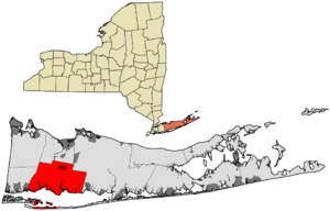
Location of Islip in Suffolk County, New York
|
|||
| Country | |||
| State | |||
| County | Suffolk | ||
| Named for | Islip, Northamptonshire | ||
| Government | |||
| • Type | Civil Township | ||
| Area | |||
| • Total | 162.98 sq mi (422.10 km2) | ||
| • Land | 103.80 sq mi (268.84 km2) | ||
| • Water | 59.17 sq mi (153.26 km2) | ||
| Elevation | 7 ft (2 m) | ||
| Population
(2020)
|
|||
| • Total | 339,938 | ||
| • Density | 3,275.9/sq mi (1,264.5/km2) | ||
| Time zone | UTC-5 (Eastern (EST)) | ||
| • Summer (DST) | UTC-4 (EDT) | ||
| ZIP code |
11705, 11706, 11716, 11717, 11718, 11722, 11730, 11739, 11749, 11751, 11752, 11760, 11769, 11770, 11782, 11795, 11796, 11702 (part), 11729 (part), 11742 (part), 11741 (part)
|
||
| Area code(s) | 631, 934 | ||
| FIPS code | 36-38000 | ||
| GNIS feature ID | 0979097 | ||
Islip (pronounced EYE-slip) is a town located in Suffolk County, New York. It's on the South Shore of Long Island. In 2020, about 339,938 people lived here, making it one of the largest towns in the New York metropolitan area.
The Town of Islip also includes a smaller area called Islip, which is a hamlet and a census-designated place. This means it's a community that isn't officially a village or city.
Contents
History of Islip
Islip's story began in 1664 when Matthias Nicoll moved to New York from a town also called Islip in England. His son, William Nicoll, later bought a large piece of land in 1683. This land stretched from East Islip to Bayport and included many other areas we know today.
William Nicoll bought this land from Winne-quaheagh, the chief of the Connetquot people. The yearly payment to the Governor of New York was five bushels of wheat or 25 shillings. Other important land buyers in the early days included Andrew Gibb, John Mowbray, Stephan Van Cortlandt, and Thomas Willets.
Early Government and Growth
By 1710, the local government allowed the people of Islip to elect their own officials. This gave residents a say in how their town was run. However, the town's growth was slow until after the American Revolutionary War. In the 17 years after the war, Islip grew more than it had in the previous 50 years, partly because American shipping became very important.
Tourism and the Railroad
In 1825, a lighthouse was built on Fire Island across the Great South Bay. Regular ferry service between Bay Shore and Fire Island started in 1862. A big change came in 1867 when the Long Island Rail Road (LIRR) arrived in Islip. This made it much easier for people to visit, and tourism quickly became a major part of the town's economy.
Many businesses opened to serve the hotels that appeared everywhere. Some tourists loved Islip so much that they built summer homes there. This led to a time of good fortune for both visitors and the town.
Modern Islip
As the 20th century began, diesel-powered ferries replaced older boats. New housing developments and small factories started to appear where old farms used to be. Like the rest of the country, Islip faced tough times during the Great Depression.
After World War II, many veterans returned home, and there was a big need for housing in New York City. Long Island, including Islip, saw a huge increase in population. Islip quickly changed from a quiet farming area to a busy suburb. The number of people living in Islip jumped from 71,000 in 1950 to 280,000 in 1970!
In 1987, Islip became famous for the "Garbage Barge" incident. A barge named Mobro 4000 carried trash that no one wanted. Its ash eventually ended up in Islip's landfill. After this, the Town of Islip started programs like "Keep Islip Clean" and WRAP. These efforts led to one of the first big recycling programs in the United States.
Population in Islip
Islip has grown a lot over the years. Here's how its population has changed:
| Historical population | |||
|---|---|---|---|
| Census | Pop. | %± | |
| 1790 | 609 | — | |
| 1800 | 958 | 57.3% | |
| 1810 | 885 | −7.6% | |
| 1820 | 1,156 | 30.6% | |
| 1830 | 1,653 | 43.0% | |
| 1840 | 1,909 | 15.5% | |
| 1850 | 2,602 | 36.3% | |
| 1860 | 3,845 | 47.8% | |
| 1870 | 4,597 | 19.6% | |
| 1880 | 6,453 | 40.4% | |
| 1890 | 8,783 | 36.1% | |
| 1900 | 12,545 | 42.8% | |
| 1910 | 18,346 | 46.2% | |
| 1920 | 20,709 | 12.9% | |
| 1930 | 33,194 | 60.3% | |
| 1940 | 51,182 | 54.2% | |
| 1950 | 71,465 | 39.6% | |
| 1960 | 172,959 | 142.0% | |
| 1970 | 278,880 | 61.2% | |
| 1980 | 298,897 | 7.2% | |
| 1990 | 299,587 | 0.2% | |
| 2000 | 322,612 | 7.7% | |
| 2010 | 335,543 | 4.0% | |
| 2020 | 339,938 | 1.3% | |
| U.S. Decennial Census | |||
Geography of Islip
Islip is bordered by the Atlantic Ocean to the south. To the west, it meets Babylon. Smithtown is to the north, and Brookhaven is to the east. It also has a small border with Huntington in the northwest.
The town covers about 162.8 square miles (422.1 square kilometers). A large part of this area, about 59.6 square miles (153.26 square kilometers), is water.
Islip includes parts of islands like Fire Island, Jones Beach Island, and Captree Island. These islands are separated from Long Island by the Great South Bay.
Climate in Islip
Islip has a humid continental climate. This means it has warm, humid summers and cold winters. The average temperature in January is about 31.9°F ( -0.1°C), and in July, it's around 75.0°F (23.9°C).
It rarely gets extremely cold (below -5°F or -20°C) or extremely hot (above 100°F or 38°C). Islip gets about 45.99 inches (1168 mm) of rain each year, spread out fairly evenly. Snowfall averages about 31.8 inches (80.8 cm) per year, mostly from November to April.
In August 2014, Islip experienced a record-breaking rainfall. Over 13.57 inches (345 mm) of rain fell in just 24 hours. This caused major flooding on local roads.
| Climate data for Islip, New York (Long Island MacArthur Airport), 1981–2010 normals, extremes 1984–present | |||||||||||||
|---|---|---|---|---|---|---|---|---|---|---|---|---|---|
| Month | Jan | Feb | Mar | Apr | May | Jun | Jul | Aug | Sep | Oct | Nov | Dec | Year |
| Record high °F (°C) | 69 (21) |
67 (19) |
82 (28) |
94 (34) |
98 (37) |
96 (36) |
102 (39) |
100 (38) |
93 (34) |
88 (31) |
78 (26) |
77 (25) |
102 (39) |
| Mean daily maximum °F (°C) | 38.0 (3.3) |
40.3 (4.6) |
47.3 (8.5) |
57.6 (14.2) |
67.5 (19.7) |
76.6 (24.8) |
81.7 (27.6) |
80.4 (26.9) |
73.8 (23.2) |
63.0 (17.2) |
53.2 (11.8) |
43.0 (6.1) |
60.3 (15.7) |
| Mean daily minimum °F (°C) | 23.3 (−4.8) |
25.2 (−3.8) |
31.3 (−0.4) |
40.6 (4.8) |
49.8 (9.9) |
60.2 (15.7) |
66.0 (18.9) |
65.3 (18.5) |
57.5 (14.2) |
45.5 (7.5) |
37.1 (2.8) |
28.2 (−2.1) |
44.3 (6.8) |
| Record low °F (°C) | −7 (−22) |
0 (−18) |
5 (−15) |
23 (−5) |
32 (0) |
42 (6) |
50 (10) |
45 (7) |
38 (3) |
28 (−2) |
11 (−12) |
5 (−15) |
−7 (−22) |
| Average precipitation inches (mm) | 3.64 (92) |
3.26 (83) |
4.44 (113) |
4.34 (110) |
3.78 (96) |
4.27 (108) |
3.43 (87) |
3.98 (101) |
3.58 (91) |
3.79 (96) |
3.67 (93) |
4.06 (103) |
46.24 (1,173) |
| Average snowfall inches (cm) | 6.7 (17) |
7.1 (18) |
4.5 (11) |
0.6 (1.5) |
0 (0) |
0 (0) |
0 (0) |
0 (0) |
0 (0) |
0 (0) |
0.5 (1.3) |
5.4 (14) |
24.8 (62.8) |
| Average precipitation days (≥ 0.01 in) | 11.0 | 9.1 | 10.5 | 11.3 | 11.1 | 10.1 | 9.1 | 8.5 | 8.6 | 8.5 | 10.3 | 10.8 | 118.9 |
| Average snowy days (≥ 0.1 in) | 3.7 | 3.4 | 2.3 | 0.3 | 0 | 0 | 0 | 0 | 0 | 0 | 0.2 | 2.4 | 12.3 |
| Source: NOAA | |||||||||||||
Economy
Some companies have their main offices in Islip. For example, NBTY and Sigma Corporation are both based in Ronkonkoma, which is part of the Town of Islip.
Communities and Locations
Islip is made up of several smaller communities. Some are "villages," which are officially incorporated, and others are "hamlets," which are unincorporated. Some communities are located on Fire Island (marked with ✝).
Villages (incorporated)
Hamlets (unincorporated)
- Bay Shore
- Bayport
- Baywood
- Bohemia
- Brentwood
- Central Islip
- East Islip
- Great River
- Hauppauge (partially; with the Town of Smithtown)
- Holbrook (partially; with the Town of Brookhaven)
- Holtsville (partially; with the Town of Brookhaven)
- Islip
- Islip Terrace
- Kismet ✝
- Lake Ronkonkoma (partially; with the Towns of Brookhaven and Smithtown)
- Lonelyville ✝
- North Bay Shore
- North Great River
- Oakdale
- Ronkonkoma (partially; with the Town of Brookhaven)
- Sayville
- West Bay Shore
- West Islip
- West Sayville
Other Communities
- Atlantique ✝
- Captree
- Corneille Estates ✝
- Dunewood ✝
- East Fire Island (Middle Island)
- Edgewood (Brentwood ZIP code)
- Fair Harbor ✝
- Lakeland (Ronkonkoma ZIP code)
- Robbins Rest ✝
- Seaview ✝
- Sexton Island
- West Fire Island (Thompson's Island)
State Parks
Islip is home to several beautiful state parks where you can enjoy nature:
- Bayard Cutting Arboretum State Park
- Brentwood State Park
- Connetquot River State Park Preserve
- Heckscher State Park
- Robert Moses State Park
Transportation
Islip has various ways to get around, from airports to trains and roads.
Airports
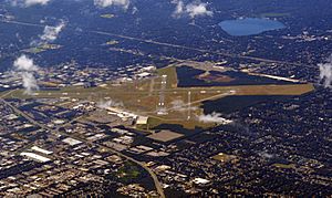
Long Island MacArthur Airport is located in Ronkonkoma, within the Town of Islip. It's owned by the town and helps people travel by air. The New York Air Route Traffic Control Center (ARTCC), which manages air traffic, is also here.
There's also a smaller airport called Bayport Aerodrome. It's used for older, classic aircraft and is also owned by the Town of Islip.
Railroad Lines
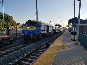
The Long Island Rail Road (LIRR) has two lines that run through Islip. The Montauk Branch has stations from Bay Shore to Sayville. The Main Line goes through the northern part of town, with stations in Brentwood, Central Islip, and Ronkonkoma. Ronkonkoma is a major transportation hub.
Bus Service
Suffolk County Transit buses provide public transportation throughout the Town of Islip, helping people get to different communities.
Major Roads
Islip has several important roads and highways:
 I-495 is the Long Island Expressway, a major highway that runs through the northern part of the town.
 Southern State Parkway is a parkway that connects Islip to other towns. Trucks are not allowed on this parkway.
 Heckscher State Parkway continues from the Southern State Parkway and leads to Heckscher State Park.
 Sagtikos State Parkway runs from south to north, connecting different parts of the town.
 Robert Moses Causeway connects Robert Moses State Park to the Southern State Parkway.
 Ocean Parkway runs along Jones Beach Island.
 NY 27 is Sunrise Highway, another important highway that allows trucks.
 NY 27A is Montauk Highway in the western part of the town.
 NY 454 is Veterans' Memorial Highway, a divided highway that passes by Long Island MacArthur Airport.
Ferries
Ferries are available to take passengers to Fire Island. You can catch them from Bay Shore and Sayville. These ferries go to various communities on Fire Island, some of which are in Islip and others in the Town of Brookhaven.
From Bay Shore, ferries go to places like Atlantique, Dunewood, Fair Harbor, Kismet, Ocean Bay Park, Ocean Beach, Saltaire, and Seaview.
From Sayville, ferries go to Cherry Grove and Fire Island Pines, which are popular vacation spots. They also go to Sailors Haven.
See also
 In Spanish: Islip (Estados Unidos) para niños
 | Roy Wilkins |
 | John Lewis |
 | Linda Carol Brown |


