Great South Bay facts for kids
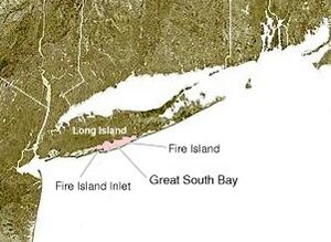
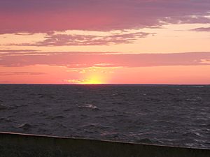
The Great South Bay is a large, shallow body of water in New York State. It's actually a type of lagoon, which is a shallow body of water separated from a larger body of water by a barrier. This bay sits between Long Island and Fire Island.
The Great South Bay is about 45 miles (72 kilometers) long. It's not very deep, usually around 4 feet 3 inches (1.3 meters), but it can be as deep as 20 feet (6.1 meters) in some spots. Fire Island, a barrier island, helps protect the bay from the big waves of the Atlantic Ocean. Jones Beach Island and Captree Island also help protect the bay.
You can reach the bay from the ocean through a narrow opening called Fire Island Inlet. This inlet is located between the western tip of Fire Island and the eastern tip of Jones Beach Island. On its western side, the Great South Bay connects to South Oyster Bay. To the east, it connects with Patchogue and Moriches bays. The Robert Moses Causeway and the Great South Bay Bridge cross parts of the bay, leading to Robert Moses State Park.
History of the Bay Area
In the early 1600s, European settlers arrived in this area. They met the native Meroke tribes who lived around the bay. Some of the first British families to settle here were the Smith, Carman, and Hewlett families. Many towns along Long Island's South Shore are near the Great South Bay. These include Lindenhurst, Babylon, Islip, Oakdale, Sayville, Bayport, Blue Point, Patchogue, Bellport, Shirley, and Mastic Beach.
Protecting the Bay's Environment
A long time ago, in the late 1800s, the Great South Bay was famous for its seafood. Many clams eaten across the region and even the country came from here. The first oysters ever sent from the United States to Europe were also from the Great South Bay!
However, by the late 1900s, a lot of the natural habitats in the bay were lost. In 2012, a very strong storm called Hurricane Sandy hit the area. It caused a lot of damage to Fire Island's beaches and created several new openings, or "breaches," in the barrier island. The biggest breach formed near Bellport, Long Island, in a place once known as Old Inlet.
At first, people worried these new openings would cause more flooding. But it turned out that the breaches actually helped the bay. They allowed more ocean water to flow in and out, which changed the saltiness (salinity) and nutrient levels in the water. After about 75 years, the bay started to "flush itself out," which means the water quality began to improve.
The U.S. Government National Wildlife Preserve manages a seven-mile stretch of land called The Otis Pike Fire Island High Dune Wilderness. This area has strict rules against making any unauthorized changes, so the Old Inlet breach has stayed open. Other breaches caused by Hurricane Sandy were closed by the Army Corps of Engineers.
In 2012, a non-profit group called Save the Great South Bay (STGSB) was created. This group works to protect the bay's water and beaches. They are especially concerned about boat sewage being pumped into the bay, as this can harm the environment.
 | James Van Der Zee |
 | Alma Thomas |
 | Ellis Wilson |
 | Margaret Taylor-Burroughs |


