
Patchogue, New York facts for kids
Quick facts for kids
Patchogue, New York
|
|
|---|---|
| Incorporated Village of Patchogue | |

The Four Corners in downtown Patchogue, where West & East Main Streets meet South & North Ocean Avenues
|
|

U.S. Census map
|
|

Patchogue, New York
Location in Long Island

Patchogue, New York
Location in New York
|
|
| Country | |
| State | |
| County | Suffolk |
| Town | Brookhaven |
| Area | |
| • Total | 2.52 sq mi (6.53 km2) |
| • Land | 2.26 sq mi (5.85 km2) |
| • Water | 0.26 sq mi (0.67 km2) |
| Elevation | 20 ft (6 m) |
| Population
(2020)
|
|
| • Total | 12,408 |
| • Density | 5,490.27/sq mi (2,119.54/km2) |
| Time zone | UTC−05:00 (Eastern Time Zone) |
| • Summer (DST) | UTC−04:00 |
| ZIP Code |
11772
|
| Area codes | 631, 934 |
| FIPS code | 36-56660 |
| GNIS feature ID | 0959977 |
Patchogue (pronounced PATCH-og) is a small village located in Suffolk County, New York. In 2020, about 12,408 people lived there.
The Incorporated Village of Patchogue is a community within the town of Brookhaven. It sits on the south shore of Long Island, right next to the Great South Bay.
Contents
Exploring Patchogue's Past
Patchogue is about 60 miles (97 km) east of Manhattan. It officially became a village in 1893.
Back in 1812, only 75 people lived in Patchogue. This information comes from The Brooklyn Eagle newspaper in 1930.
Early Industry and Energy
From 1904 to 1926, a company called the Patchogue Former Manufactured Gas Plant (MGP) operated here. This small company turned coal or petroleum into a gas. This gas was used for lighting and in factories. Later, a bigger company called Long Island Lighting Company (LILCO) bought it.
The Patchogue Theatre's Story
The Patchogue Theatre first opened its doors in 1923. Over the years, it changed a few times. It was once divided into three smaller movie theaters. Then, it became one large movie theater again.
The theater closed in the late 1980s. But in the mid-1990s, the village bought it and fixed it up completely. Today, it's a beautiful theater that can seat 1,166 people.
Historic Churches in Patchogue
Several churches in Patchogue are very old and important. They are listed on the National Register of Historic Places. This means they are special historical buildings. These churches include:
- The Congregational Church of Patchogue on East Main Street.
- The United Methodist Church on South Ocean Avenue.
- St. Paul's Episcopal Church on Rider Avenue.
A Great Neighborhood to Live In
In 2019, the downtown area of Patchogue was named one of America's four "Great Neighborhoods" by the American Planning Association. This award recognizes places that are well-planned and help bring people together. Since 2007, over 300 neighborhoods have received this honor.
Patchogue's Location and Landscape
Patchogue covers a total area of about 2.5 square miles (6.5 km²). Most of this area, about 2.2 square miles (5.7 km²), is land. The rest, about 0.3 square miles (0.8 km²), is water.
The village has a natural riverfront and a harbor. These natural features have been important since Patchogue was founded. They have helped it grow into a modern and complete community.
Who Lives in Patchogue?
| Historical population | |||
|---|---|---|---|
| Census | Pop. | %± | |
| 1880 | 2,503 | — | |
| 1900 | 2,926 | — | |
| 1910 | 3,824 | 30.7% | |
| 1920 | 4,031 | 5.4% | |
| 1930 | 6,860 | 70.2% | |
| 1940 | 7,181 | 4.7% | |
| 1950 | 7,361 | 2.5% | |
| 1960 | 8,838 | 20.1% | |
| 1970 | 11,582 | 31.0% | |
| 1980 | 11,291 | −2.5% | |
| 1990 | 11,060 | −2.0% | |
| 2000 | 11,919 | 7.8% | |
| 2010 | 11,798 | −1.0% | |
| 2020 | 12,408 | 5.2% | |
| U.S. Decennial Census | |||
In 2000, there were 11,919 people living in Patchogue. The population density was about 5,301 people per square mile (2,047 per km²).
Many different groups of people live in Patchogue. In 2000, about 81% of the people were White. About 24% of the population identified as Hispanic or Latino.
The average age of people in Patchogue in 2000 was 35 years old. About 22.5% of the residents were under 18 years old.
Patchogue's Economy
The Blue Point Brewing Company is located in Patchogue.
Downtown Patchogue is a very important business area. It is the second largest financial district in Eastern Long Island. It's also a major transport hub for Eastern New York and Southern Connecticut.
There is also a museum in the village called MoCA Long Island.
Learning and Education in Patchogue
Patchogue has many educational opportunities for students of all ages.
Schools for Kids and Teens
The Patchogue-Medford Public Schools serve most of Patchogue. Some western parts of the village are served by the Bayport-Blue Point School District.
The schools include:
- Middle School:
- South Ocean Middle School
- Elementary Schools:
- Bay Elementary School
- River Elementary School
- Medford Elementary School
- Barton Elementary School
There are also private schools like Holy Angels Regional School and Emanuel Lutheran Preschool.
Higher Education and Adult Learning
For older students and adults, there are several options:
- St. Joseph's University (New York) offers college programs.
- The Patchogue-Medford Library and the Carnegie Library provide many resources. In 2010, the Patchogue-Medford Library won a national award for its programs that help people who speak two languages.
Media and News in Patchogue
Patchogue has its own local news sources.
The newspaper The Long Island Advance has been around since 1871. It was first printed by Timothy J. Dyson.
A news website called GreaterPatchogue.com started in 2015. It is owned by a local company based in Patchogue.
Several radio stations are licensed to serve Patchogue, including Big 98.1, WALK-FM, WBLI, WLID, and WNYG.
Getting Around Patchogue
Patchogue has good transportation options.
Local Buses
The village has its own small bus system called Patchogue-Village Transit. It has several routes that go in and out of downtown.
Train and Ferries
The Long Island Rail Road (LIRR) Montauk Branch serves Patchogue. The train station is a central point for many Suffolk County Transit bus lines.
From near the LIRR station, you can also catch ferries. These ferries take passengers to Fire Island, including the Watch Hill Visitor Center and Davis Park, New York.
Main Roads
The main roads that go through Patchogue are Montauk Highway and Sunrise Highway. Other important roads include South and North Ocean Avenues, County Route 101, and New York State Route 112.
Famous People from Patchogue
Many interesting people have connections to Patchogue:
- Emily Newton Barto, a painter, was born here.
- Walta Borawski, an American poet.
- Frank Castellano, a captain of a US Navy ship.
- Mike Fagan, a professional bowler.
- Billy Idol, a famous English musician, lived in Patchogue when his family moved to the United States in 1958.
- Leila Kenzle, an actress, was born in Patchogue.
- Biz Markie, a well-known rapper, lived in Patchogue.
- Chrisette Michele, a Grammy-winning singer, grew up in Patchogue.
- Michael P. Murphy, a Navy SEAL officer who received the Medal of Honor, grew up here.
- Robert Pelletreau, a diplomat and ambassador, was born in Patchogue.
- Sylvia Porter, a journalist, was born in Patchogue.
- William T. Sanders, an anthropologist who studied ancient cultures, was born and grew up in Patchogue.
- Jeff Schaefer, a baseball player for the Chicago White Sox, was born in Patchogue.
- Edgar A. Sharp, a United States representative, was born in Patchogue.
- Renée Felice Smith, an actress on the TV show NCIS: Los Angeles, went to high school in Patchogue.
- William Stuart-Houston (who was Adolf Hitler's nephew) lived in Patchogue with his family.
Images for kids
-

Sketch of early Patchogue
-

Historical Markers in NYS - Places President George Washington visited in 1790
-
George Bradford Brainerd. Creek, Patchogue, Long Island, ca. 1872–1878. Brooklyn Museum
-
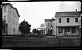
George Bradford Brainerd. Ocean Avenue, Patchogue, Long Island, ca. 1872–1887. Brooklyn Museum
-

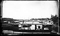
View of Patchogue in 1930


._Creek,_Patchogue,_Long_Island,_ca._1872-1878.jpg)

.jpg)
See also
 In Spanish: Patchogue para niños
