Fire Island facts for kids
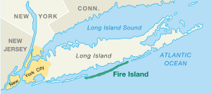
Fire Island is a long, thin island located off the southern coast of Long Island in New York, USA. It's one of several "barrier islands" that protect the mainland from ocean storms.
Sometimes, people use the name "Fire Island" to talk about a group of islands that are very close together. These islands are about 31 miles (50 km) long and can be anywhere from 525 feet (160 m) to 1,300 feet (400 m) wide. The total land area of Fire Island is about 9.6 square miles (24.9 square kilometers).
Fire Island is part of Suffolk County. It has two small villages and several smaller communities. While only about 777 people live there all year round, thousands of visitors and residents come to enjoy the island during the summer months. Some areas like Cherry Grove and Fire Island Pines are especially popular vacation spots.
Contents
History of Fire Island
Early Days and Growth
In the 1600s, a man named William "Tangier" Smith owned the whole island.
- The first big house was built in 1795 in Cherry Grove.
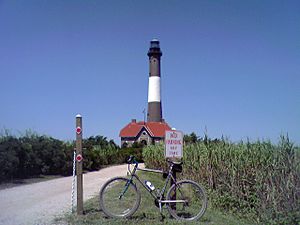
- The first Fire Island Lighthouse was built in 1825. The one you see today was built in 1858. Lighthouses help guide ships safely.
- In 1855, David S.S. Sammis bought land near the lighthouse and built the Surf Hotel. This hotel later became the first state park on Long Island in 1908.
- By 1887, the Coast Guard had set up 11 stations on the island to help save lives at sea.
- More communities like Ocean Beach (1908) and Saltaire (1910) started to grow.
- In 1921, small bungalows (simple houses) were brought over to create new communities like Cherry Grove.
The Great Hurricane of 1938 caused a lot of damage to the island. However, some places, like Duffy's Hotel, were not too badly hit. After this, more people started visiting and building homes on the island. In the 1960s, a male model named John B. Whyte helped develop Fire Island Pines, which now has some of the most expensive homes on the island.
In 1964, a road was built to the western end of the island. But people who lived there worried that more roads would be built through the middle of the island, changing its natural beauty. They worked together to stop these plans. In September 1964, President Lyndon B. Johnson signed a law that created the Fire Island National Seashore. This protected much of the island's natural environment.
Protecting the Beach
In 2009, a big project called "beach renourishment" took place. This involved adding a lot of sand to the beaches to make them wider and build up the dunes. This project cost millions of dollars, and people on Fire Island helped pay for it through taxes.
This project was very important because it helped protect the island when Hurricane Sandy hit in 2012.
Hurricane Sandy in 2012
Hurricane Sandy caused a lot of damage to Fire Island in 2012. The high tides created three new openings, or "breaches," in the island, especially on the less populated eastern side. One of the biggest breaches was at Old Inlet. People debated whether to close this opening or let nature take its course.
Even though 80% of the homes were flooded and 90 homes were completely destroyed, most of the 4,500 homes on the island survived. Officials said that the beach renourishment project from 2009 really helped save the island from even worse damage.
Geography
|
|
Fire Island is usually about 3.8 miles (6.2 km) away from the south shore of Long Island. It is separated from Long Island by the Great South Bay. You can reach the island by car at both its western and eastern ends. However, most of the island does not allow cars. Instead, you can take ferries from places like Bay Shore, Sayville, and Patchogue.
How the Island Has Changed
Fire Island's shape and size have changed a lot over time. It used to be much longer, stretching over 60 miles (97 km).
Around 1683, a new opening called Fire Island Inlet broke through, separating Fire Island from another island. The Fire Island Lighthouse was built right next to this inlet in 1858. But over the years, the western end of Fire Island has grown, so the lighthouse is now about 6 miles (9.7 km) away from the inlet!
In 1931, another storm created the Moriches Inlet, separating Fire Island from Southampton. This new inlet, along with structures built to protect beaches, has caused some parts of Fire Island to erode, meaning the sand gets washed away. Over the years, at least six other openings have appeared and then disappeared on the island.
Landmarks and Preserves
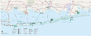
Most of Fire Island, except for the western 4.5 miles (7.2 km), is protected as part of the Fire Island National Seashore. This means it's a special area where nature is preserved. Robert Moses State Park is on the western part of the island and is a popular spot for fun and recreation. The Fire Island Light (lighthouse) is just east of this park.
There is also a memorial for TWA 800 on the eastern end, at Smith Point County Park. This memorial was built in June 2002, near where the airplane crashed into the sea.
Locations on Fire Island
Here are some of the places you can find on Fire Island, listed from west to east:
Town of Babylon
Town of Islip
- Robert Moses State Park (part)
- Fire Island Light
- Kismet
- Seabay Beach
- Saltaire (a village)
- Fair Harbor
- Dunewood
- Lonelyville
- Atlantique
- Robbins Rest
- Fire Island Summer Club
- Corneille Estates
- Ocean Beach (a village)
- Seaview
Town of Brookhaven
- Seaview
- Ocean Bay Park
- Point O'Woods
- Oakleyville
- Sunken Forest
- Cherry Grove
- Fire Island Pines
- Talisman/Barrett Beach
- Water Island
- Blue Point Beach
- Davis Park/Ocean Ridge
- Watch Hill, a National Park Service area with a marina, campground, and nature trail.
- Otis Pike Fire Island High Dune Wilderness
- Bellport Beach
- Smith Point County Park
- Moriches Inlet
Other Small Islands Nearby
These small islands are also part of the Fire Island National Seashore:
- Sexton Island: A small island with about 20 private summer houses. It has no ferry or electricity.
- West Fire Island: A small island with about a dozen houses, also without phone or electricity.
- East Fire Island: A longer island next to West Fire Island, but it's not inhabited. You can visit by boat.
- Ridge Island
- Pelican Island
- John Boyle Island
- Hospital Island
- Money Island
- Penny Island
Other Places
- Clam Pond: A small cove between Saltaire and Fair Harbor.
Life on Fire Island
The number of people living on Fire Island changes a lot throughout the year. Very few people live there in the winter, but the population grows to thousands from late spring to early fall.
Most houses are built in a simple, "bungalow" style. Some are right on the beach, while others are along boardwalks or concrete paths, like a tiny city. For the people who live there all year, there are schools, churches, and shops. There's even a special school bus that can drive on the sand to take kids to the mainland!
The quieter villages on Fire Island offer a peaceful escape, while the larger towns have a more lively feel with clubs, restaurants, and outdoor dining. Two of these towns, Fire Island Pines and Cherry Grove, are known for being very welcoming to all visitors.
The villages of Ocean Beach and Saltaire do not allow cars during the busy summer tourist season (from Memorial Day to Labor Day). You can only walk or ride bicycles (during certain hours in Ocean Beach). During the off-season, only a few special permits are given for year-round residents and workers to drive. The community of Davis Park never allows cars or bicycles.
In 1992, a writer from The New York Times noticed that because there weren't many stores or TV options, especially in winter, kids on the island often felt bored and were actually excited to go to school!
Famous Summer Visitors
Since the 1920s, many famous actors, writers, and artists have spent their summers on Fire Island. Here are a few:
- Fanny Brice, an actress.
- Mel Brooks, a writer and comedian.
- Tina Fey, a writer and actress known for 30 Rock.
- Henry Fonda, a famous actor.
- Joseph Heller, a writer.
- John Lennon, from The Beatles.
- Christopher Noth, an actor from Sex and the City.
- Carl Reiner, a writer and comedian.
- Lea Thompson, an actress from Back to the Future.
- Herman Wouk, a writer.
Emergency Services
Fire Island's unique location and changing geography make it special for emergency services. The island has ten fire departments and two police departments. Because there are no regular roads on most of the island, fire trucks are specially changed to be four-wheel drive vehicles with big tires. This helps them drive on the sand, even when it's washed out.
Until 1986, there was no ambulance service on Fire Island. So, the village of Saltaire started its own rescue company, followed by Ocean Beach and Fair Harbor. Fire departments on Fire Island often help each other out, and some fire departments on Long Island have special boats that can cross the Great South Bay to help.
The special off-road fire trucks and trained firefighters are very important for fighting wildfires, like the ones that happened in the Long Island Central Pine Barrens in 1995.
For medical emergencies, there are hospitals directly across the Great South Bay on Long Island. The Suffolk County Police Department has special boats that can take people who need urgent medical care across the bay to meet ambulances. There is also one emergency road that connects Long Island to the western end of Fire Island.
The Suffolk County Police Department is the main law enforcement agency. The village of Ocean Beach also has its own police department. It's common for police to give tickets and then send visitors who cause trouble off the island by water taxi, and the person has to pay for it!
The United States Coast Guard also has a base on Fire Island and patrols the area by air and sea. One of the oldest Coast Guard stations in America has been operating on Fire Island since 1849.
Education
Children on Fire Island go to schools in different districts:
- Fire Island Union Free School District (Woodhull School for grades PK-6)
* After Woodhull, students can choose to go to high school in either the Bay Shore School District or the Islip School District.
- William Floyd Union Free School District
- Center Moriches Union Free School District
- East Moriches Union Free School District
- Remsenburg-Speonk Union Free School District (for West Hampton Dunes)
Fire Island in Popular Culture
Fire Island has been featured in many books, songs, and TV shows:
- The 1955 novel Auntie Mame mentions Fire Island.
- The 1974 novel The Front Runner takes place partly on the island.
- The 1975 Brian Eno album Another Green World has a song called "Over Fire Island."
- The Village People included a song called "Fire Island" on their 1977 album.
- The song "Come to Me" by France Joli became very famous after she performed it on Fire Island in 1979.
- The 1980 teen novel My First Love and Other Disasters by Francine Pascal is set on Fire Island.
- The 1991 play Lips Together, Teeth Apart by Terrence McNally is set on Fire Island.
- The song "Pretty Deep" on the 1997 album Lovesongs for Underdogs by Tanya Donelly mentions a visit to Fire Island.
- Fire Island is often mentioned on the TV show Will & Grace, which started in 1998.
- When Ocean Meets Sky, a 2003 documentary, tells the 50-year history of the Fire Island Pines community.
- The 2003 album Welcome Interstate Managers by Fountains of Wayne has a song called "Fire Island."
- The song "Gay Messiah" on the 2004 album Want Two by Rufus Wainwright mentions Fire Island.
- The 2004 mockumentary Beach Comber was filmed on Fire Island.
- The 2006 ABC reality show One Ocean View was filmed on Fire Island.
- Fire Island is important in the 2008 novel The Last Summer (of You and Me) by Ann Brashares.
- The 2019 mystery film Last Ferry features a tourist visiting Fire Island during the off-season.
- The 2022 romantic comedy Fire Island is about a group of friends on vacation there.
- The TV series American Horror Story: NYC includes scenes set on Fire Island in 1981.
- In 2024, actor Brian J. Smith released A House is Not a Disco, a documentary about the culture on the island.
See also
 In Spanish: Fire Island para niños
Images for kids
-
Panorama of Fire Island from the top of the Fire Island Light (distorted view)
 | Chris Smalls |
 | Fred Hampton |
 | Ralph Abernathy |


