Fire Island National Seashore facts for kids
Quick facts for kids Fire Island National Seashore |
|
|---|---|
|
IUCN Category V (Protected Landscape/Seascape)
|
|
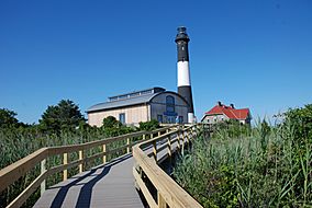
Fire Island Lighthouse
|
|
| Location | Fire Island, New York, United States |
| Nearest city | Patchogue, New York |
| Length | 26 mi (42 km) |
| Area | 19,579 acres (79.23 km2; 30.592 sq mi) |
| Established | September 11, 1964 |
| Visitors | 393,749 (in 2022) |
| Governing body | National Park Service |
| Website | Fire Island National Seashore |
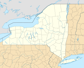
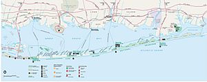
Fire Island National Seashore (FINS) is a special protected area in the United States. It looks after a 26-mile part of Fire Island, which is a long, narrow island. This island is about 30 miles long and half a mile wide. It's separated from Long Island by a body of water called the Great South Bay. Fire Island is in New York State, specifically in Suffolk County.
There are 17 private towns and villages inside the Fire Island National Seashore. Some of these include Saltaire, Fire Island Pines, and Ocean Beach. Only two bridges lead to Fire Island and the national seashore. There are no public roads within the seashore itself. The Robert Moses Causeway takes you to Robert Moses State Park on the west side of Fire Island. The William Floyd Parkway leads to the east side of the island. You can also get to the seashore by private boat or by ferry from towns like Patchogue, Sayville, and Bay Shore on Long Island.
Fire Island National Seashore was created by the National Park Service on September 11, 1964.
A separate part of Fire Island National Seashore is on Long Island. It protects the home of William Floyd. He was an American Revolutionary War general and signed the Declaration of Independence. This historic home, called the William Floyd House, is listed on the National Register of Historic Places. It is located in Mastic Beach, New York.
Contents
Fun Things to Do at Fire Island
Fire Island National Seashore offers many cool places to explore and enjoy nature. Here are some of the main attractions:
Fire Island Lighthouse
The Fire Island Light is a tall, historic lighthouse. It's located near the western end of the seashore, close to Robert Moses State Park. You can climb to the top for amazing views!
Sailor's Haven
Sailor's Haven is a popular spot with a 1.5-mile boardwalk trail. This trail goes through a unique area called the Sunken Forest. Sailor's Haven also has a visitor center, a general store, and a public marina where boats can dock.
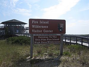
Otis Pike Fire Island High Dune Wilderness
This special area is located on the eastern end of Fire Island. It's the only federally protected U.S. Wilderness Area in New York State. It's a wild, untouched place where nature is left to grow freely.
Exploring the Wilderness Area
The Otis Pike Fire Island High Dune Wilderness is also known as Fire Island Wilderness. It's a 1,380-acre wilderness area on Fire Island. This wild part of the island is about 7 miles long and is on the eastern side. The United States Congress officially made it a wilderness area in 1980.
Why is it Called Otis Pike?
The wilderness area is named after Otis G. Pike. He was a Congressman from New York. He helped create the Fire Island National Seashore and worked hard to get public support for it. He also helped pass the law that established this new national park. It's the only federally protected wilderness area in New York State. It's also one of the smallest wilderness areas managed by the National Park Service.
What You Can See in the Wilderness
This wilderness area has pine forests, grassy wetlands, and sand dunes. These habitats are home to many animals, including white-tailed deer, herons, and birds that migrate. The actual beaches facing the Atlantic Ocean are not technically part of the wilderness. You can go hiking, back-country camping, and fishing in this special area.
How to Visit the Wilderness
You can get to the Otis G. Pike Wilderness from Watch Hill. Watch Hill can be reached by ferry or private boat during certain seasons. You can also get there from Smith Point County Park, which you can reach by car or bus all year round. The Wilderness Visitor Center is on the eastern edge of the wilderness, right next to Smith Point County Park.
The Old Inlet Breach
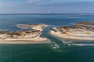
Old Inlet is just west of Smith Point County Park, within the wilderness area. This spot has seen times when the Atlantic Ocean broke through Fire Island and connected with the Great South Bay. This is called a "breach."
The 2012 Breach
The most recent breach happened during the high tides from Hurricane Sandy in October 2012. A week after the storm, the breach was 276 feet wide on the Atlantic side. By April 5, 2013, it had grown to 856 feet wide.
What Happened Next?
Officials from the National Park Service discussed whether to close the breach. Their plans for breaches in wilderness areas usually involve watching them first. By 2014, the breach had become stable, and they continued to monitor it. Some local residents wanted the breach closed because they thought it caused more flooding.
However, the breach actually helped improve the water quality in Great South Bay. Before the breach, the bay was becoming more polluted from suburban runoff. The breach also helped fish and clams return to the bay after being gone for many years due to pollution.
Officials decided to close two other breaches that formed near Moriches Inlet after Hurricane Sandy. But for the Old Inlet breach, the National Park Service decided to let nature take its course. By summer 2022, the breach was filling with sand. It had shrunk a lot, becoming less than 100 feet wide.
Images for kids
See also
 | Emma Amos |
 | Edward Mitchell Bannister |
 | Larry D. Alexander |
 | Ernie Barnes |


