
Moriches Inlet facts for kids


Moriches Inlet (pronounced moh-RITCH-iz) is a narrow waterway. It connects Moriches Bay to the huge Atlantic Ocean. The name 'Moriches' comes from a Native American person named Meritces. They once owned land near the inlet.
This inlet acts like a natural border. It's on the eastern side of Fire Island, New York. It also marks the western edge of the long, thin island. The town of West Hampton Dunes, New York is the closest community there.
Contents
How Moriches Inlet Was Formed
Moriches Inlet wasn't always there. A big storm called a Nor'easter created it in 1931. This storm split West Hampton from Fire Island. The storm also caused a unique situation for the western part of the West Hampton island. This area is part of the town of Brookhaven, New York. However, to reach it by land from Brookhaven, you have to drive through several miles of Southampton, New York.
After it formed, Moriches Inlet grew much wider. Between 1933 and 1938, it became about 4,000 feet (1,219 meters) wide. It also got deeper. Sand was carried and dropped both in the bay and in the ocean. The widening slowed down in 1938. This happened when the Great Hurricane of 1938 opened up another inlet. That new inlet was Shinnecock Inlet, located further east.
Keeping the Inlet Open
Local leaders wanted to protect the barrier island. So, they built structures called groynes in 1952 and 1953. These groynes help control the sand and water flow. Local authorities have always wanted the inlet to stay open. This allows boats from Long Island to easily reach the ocean.
The United States Army Corps of Engineers took over maintaining the inlets and jetties in the 1980s. Jetties are like long walls built into the water. They help keep the inlet stable.
Sand Movement and Challenges
The Army Corps of Engineers faced some disagreements. Some people claimed that the groynes and jetties were causing problems. They said these structures were blocking the natural movement of sand. Sand usually moves along the coast from east to west. This movement is called longshore drift. It helps to keep beaches full of sand.
It was believed that the inlet and its groynes caused a big loss of sand on Fire Island. About 8 to 10 million cubic yards of sand were lost. This meant the beach on Fire Island became about 100 feet (30 meters) narrower. The sand depth also decreased by 12 to 16 feet (3.6 to 4.8 meters) along the entire 32-mile (51-kilometer) Fire Island beach zone.
Important Waterway
Moriches Inlet is a very important waterway. It was the main route for ships helping after a plane accident in 1996. News reports said the accident happened about 10 miles (16 kilometers) south of the inlet.
Images for kids
-
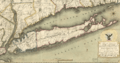
Map of Long Island from 1815 displaying the Moriches Inlet.

