
Brookhaven, New York facts for kids
Quick facts for kids
Brookhaven, New York
|
||
|---|---|---|
| Town of Brookhaven | ||
       Clockwise from top-left: Stony Brook University, mill in Frank Melville Park in Setauket, Stony Brook Village Center, Old Field Point Light, downtown Port Jefferson, Miller homestead in Miller Place, and the Long Island Museum
|
||
|
||

Location in Suffolk County
|
||
| Country | ||
| State | ||
| County | Suffolk | |
| First settled | 1655 | |
| Incorporated | 1686 | |
| Town Seat | Farmingville | |
| Government | ||
| • Type | Civil township | |
| • Body | Brookhaven Town Council | |
| Area | ||
| • Total | 531.54 sq mi (1,376.68 km2) | |
| • Land | 259.44 sq mi (671.93 km2) | |
| • Water | 272.11 sq mi (704.75 km2) | |
| Area rank | 1st (when water area included) | |
| Elevation | 79 ft (24 m) | |
| Population
(2020)
|
||
| • Total | 485,773 | |
| • Rank | 3rd | |
| • Density | 1,873.4/sq mi (724.18/km2) | |
| Time zone | UTC−05:00 (Eastern Time Zone) | |
| • Summer (DST) | UTC−04:00 | |
| Area code(s) | 631, 934 | |
| FIPS code | 36-10000 | |
| GNIS feature ID | 0978758 | |

Brookhaven is a really big suburban town in Suffolk County, Long Island, New York. It's one of the largest towns in the United States by population. In 2022, about 488,497 people lived here. This makes it the second most populated town in New York State.
The first settlement in Brookhaven was called Setauket. It started as small farming communities in the mid-1600s. Later, in the 1800s, Brookhaven became a major center for building ships. Because it's close to New York City, it became a popular place for vacation resorts. After World War II, many more people moved here, causing a big population increase.
Brookhaven is home to two famous research centers: Stony Brook University and Brookhaven National Laboratory. These two places employ a lot of people in the town. Tourism is also a big part of the local economy. You can find busy downtown areas in Port Jefferson and Patchogue. Port Jefferson is a hub for the Bridgeport & Port Jefferson Ferry. The Long Island Rail Road has served the area for a long time.
Contents
History
How Brookhaven Started
The first people known to live here were Native Americans. They spoke Algonquian languages and belonged to the Setauket and Unkechaug tribes. English settlers arrived around 1640. In 1655, some settlers bought land from these tribes. This year, 1655, is now recognized as the founding year of Brookhaven. It was when the first land deal happened in Setauket.
This makes Brookhaven the fifth English town founded on Long Island. Before it were Southampton, Southold, Huntington, and East Hampton.


The first English settlement was named "Setauket" after the local Native American tribe. For a while, "Brookhaven" and "Setauket" were used for both the village and the larger town. It wasn't until the 1800s that Setauket became just a smaller area within the town of Brookhaven. There's even a hamlet today called Brookhaven, which was named after the larger township in 1879.
The first land purchase in 1655 included areas like Setauket, Stony Brook, and Port Jefferson. In 1664, Richard Woodhull bought more land. This expanded the town eastward along the North Shore. It included places like Mount Sinai, Miller Place, and Wading River.
Brookhaven became part of the Province of New York in 1664. In 1666, Governor Richard Nicolls gave the town a special document called a patent. This confirmed their ownership of the land. Later, in 1686, Governor Thomas Dongan issued another patent. This one gave the town more powers and set up a local government. The town's official seal was also created then. The letter "D" on the seal was the town's official cattle earmark from 1665. The olive branch on the seal likely meant peace, and the whaling tools showed that whaling was a very important business back then. Today's seal is a new design, but it still has these original symbols and the 1655 founding date.
Life in Colonial Times

Early English settlers in Brookhaven were mostly farmers, fishers, and whale hunters. The town was very rural, with only a few families in each area, but miles of land. Fishing helped the economy in coastal areas. A big shopping or business center didn't really exist until the early 1800s.
Brookhaven was first settled by English colonists who came from Southold. It was first under the control of the New Haven Colony in Connecticut. In 1662, it moved to the Connecticut Colony. Then, in 1664, England took over New Netherland, and Brookhaven became part of the new colony of New York.
The American Revolutionary War
During the American Revolutionary War, British forces took control of Long Island, including Brookhaven. Many residents supported the British. However, Brookhaven also saw brave actions by Americans during the war.
One famous group was the Culper Spy Ring. These spies worked for George Washington. Many of them were from Brookhaven and operated in areas controlled by the British. Another event was Benjamin Tallmadge's daring raid. He and his team rowed from Connecticut to Cedar Beach. They then marched across Long Island to attack the British fort at Manor St. George. This led to the Battle of Fort St. George and the burning of the fort. There was also a smaller fight in Setauket. The British had turned the local church into a fort. You can still see some bullet holes in the walls of the nearby Caroline Church.
Growing Up: From Ships to Science


In the mid-1800s, some Brookhaven communities became busy shipbuilding ports. Port Jefferson and Patchogue were the most successful. They are still the town's busiest downtown areas today. Whaling and cutting wood for fuel also became important industries.
Railroads arrived in Brookhaven in the mid-1800s. Trains first reached Ronkonkoma in 1843. The Port Jefferson Branch on the North Shore started running in 1873. The Bridgeport & Port Jefferson Ferry has been carrying cars and people between Port Jefferson and Bridgeport, Connecticut, since 1888. Even the famous circus owner P.T. Barnum helped start it!
From the late 1800s to the mid-1900s, many towns along the North and South Shores became popular resort spots. People from New York City, including famous celebrities, would come here for summer vacations. Many rural parts of Brookhaven were used as campgrounds for youth groups.
During the Gilded Age, wealthy people built fancy homes along the North Shore. Places like Belle Terre and Old Field changed from small fishing villages into exclusive neighborhoods for the rich.
Important scientific research also happened in Brookhaven around the early 1900s. Inventor Nikola Tesla had a research center in Shoreham. It featured the huge Wardenclyffe Tower. Today, this site is being turned into the Tesla Science Center at Wardenclyffe. Guglielmo Marconi opened one of the world's largest radio facilities, called Radio Central, in Rocky Point.
Modern Brookhaven

After World War II, Brookhaven's population grew a lot. This was partly because it was easy to get to New York City by the Long Island Rail Road and highways. The town's most famous institutions, Stony Brook University and Brookhaven National Lab, were both started after the war.
In the mid-1900s, a kind person named Ward Melville made big changes in the "Three Village" area. This includes The Setaukets, Stony Brook, and Old Field. Melville, who lived in Old Field and owned what became CVS, used his money to make Northwestern Brookhaven look like an ideal New England town. In 1939, he built the Stony Brook Village Center. It's a pretty shopping area in Stony Brook, with buildings designed to look old and colonial. In 1962, Ward Melville gave 400 acres of land for Stony Brook University to move there.

Brookhaven National Laboratory (BNL) is built on the site of Camp Upton. This was a United States Army training camp during World War I and World War II. Thousands of soldiers, including composer Irving Berlin, trained there. In 1946, the land was given to the new national laboratory, which opened the next year. Brookhaven researchers have done amazing things. They patented Maglev trains, designed one of the first video games, found the first solar neutrinos, and created the first PET scan. They also made many discoveries in particle physics. The lab has the Relativistic Heavy Ion Collider (RHIC) and the National Synchrotron Light Source. A famous physicist named I.I. Rabi helped a lot to create the lab.
Geography
Brookhaven is in the middle of Long Island. It stretches from the North Shore to the South Shore. It's the largest town in New York by total area, including water. However, some towns have more land area.
Brookhaven is bordered by Long Island Sound to the north and the Atlantic Ocean to the south. It also shares borders with other towns like Riverhead, Southampton, Smithtown, and Islip.
A big part of Fire Island is in Brookhaven. You can reach it by a bridge at Smith Point. The Great South Bay is also part of the town.
Bald Hill in Farmingville is a large hill. It marks where the glacier that formed Long Island stopped long ago. At the top, there's a memorial for Vietnam veterans. Telescope Hill, west of Bald Hill, is slightly taller. It's the highest point in the town.
Climate
| Climate data for Brookhaven, New York (National Weather Service Forecast Office, Brookhaven National Laboratory, Upton, New York) | |||||||||||||
|---|---|---|---|---|---|---|---|---|---|---|---|---|---|
| Month | Jan | Feb | Mar | Apr | May | Jun | Jul | Aug | Sep | Oct | Nov | Dec | Year |
| Record high °F (°C) | 67 (19) |
68 (20) |
83 (28) |
90 (32) |
97 (36) |
99 (37) |
98 (37) |
102 (39) |
97 (36) |
85 (29) |
77 (25) |
68 (20) |
102 (39) |
| Mean daily maximum °F (°C) | 38.3 (3.5) |
40.1 (4.5) |
47.0 (8.3) |
57.5 (14.2) |
67.8 (19.9) |
76.3 (24.6) |
81.6 (27.6) |
80.6 (27.0) |
74.3 (23.5) |
63.3 (17.4) |
52.9 (11.6) |
43.9 (6.6) |
60.3 (15.7) |
| Mean daily minimum °F (°C) | 21.1 (−6.1) |
22.0 (−5.6) |
29.1 (−1.6) |
38.4 (3.6) |
48.2 (9.0) |
58.4 (14.7) |
64.5 (18.1) |
62.8 (17.1) |
55.5 (13.1) |
44.0 (6.7) |
34.2 (1.2) |
27.4 (−2.6) |
42.1 (5.6) |
| Record low °F (°C) | −13 (−25) |
−8 (−22) |
−7 (−22) |
12 (−11) |
28 (−2) |
34 (1) |
45 (7) |
40 (4) |
30 (−1) |
17 (−8) |
9 (−13) |
−6 (−21) |
−13 (−25) |
| Average precipitation inches (mm) | 4.04 (103) |
3.86 (98) |
4.94 (125) |
4.19 (106) |
3.65 (93) |
3.94 (100) |
3.71 (94) |
4.52 (115) |
4.20 (107) |
4.30 (109) |
3.76 (96) |
4.86 (123) |
49.97 (1,269) |
| Average snowfall inches (cm) | 9.6 (24) |
9.4 (24) |
5.1 (13) |
1.3 (3.3) |
0 (0) |
0 (0) |
0 (0) |
0 (0) |
0 (0) |
0 (0) |
0.7 (1.8) |
4.0 (10) |
30.1 (76) |
| Source: NOAA | |||||||||||||
Water Features

- Outer Barrier
- Fire Island
- Great South Bay
- Patchogue Bay
- Bellport Bay
- Narrow Bay
- Moriches Bay
People of Brookhaven
| Historical population | |||
|---|---|---|---|
| Census | Pop. | %± | |
| 1790 | 3,224 | — | |
| 1800 | 4,022 | 24.8% | |
| 1810 | 4,176 | 3.8% | |
| 1820 | 5,218 | 25.0% | |
| 1830 | 6,095 | 16.8% | |
| 1840 | 7,050 | 15.7% | |
| 1850 | 8,595 | 21.9% | |
| 1860 | 9,923 | 15.5% | |
| 1870 | 10,159 | 2.4% | |
| 1880 | 11,544 | 13.6% | |
| 1890 | 12,772 | 10.6% | |
| 1900 | 14,892 | 16.6% | |
| 1910 | 16,737 | 12.4% | |
| 1920 | 21,847 | 30.5% | |
| 1930 | 28,291 | 29.5% | |
| 1940 | 32,118 | 13.5% | |
| 1950 | 44,522 | 38.6% | |
| 1960 | 109,900 | 146.8% | |
| 1970 | 245,260 | 123.2% | |
| 1980 | 364,812 | 48.7% | |
| 1990 | 407,779 | 11.8% | |
| 2000 | 448,248 | 9.9% | |
| 2010 | 486,040 | 8.4% | |
| 2020 | 485,773 | −0.1% | |
In 2020, about 485,773 people lived in Brookhaven. The town has a mix of different people. Most residents are White (83.0%), with 6.1% Black or African American, and 4.7% Asian. About 15.6% of the population is Hispanic or Latino.
Economy
Brookhaven has many important employers. Here are the top ones from 2009:
| # | Employer | # of Employees | Location |
|---|---|---|---|
| 1 | Stony Brook University | 13,623 | Stony Brook |
| 2 | Internal Revenue Service | 3,332 | Holtsville |
| 3 | Sachem School District | 3,100 | Holbrook |
| 4 | Brookhaven National Laboratory | 2,500 | Upton |
| 5 | John T. Mather Memorial Hospital | 2,047 | Port Jefferson |
| 6 | Long Island Community Hospital | 2,030 | East Patchogue |
| 7 | St. Charles Hospital | 1,520 | Port Jefferson |
| 8 | Three Village Central School District | 1,454 | East Setauket |
| 9 | Verizon | 1,440 | Patchogue |
| 10 | William Floyd School District | 1,300 | Mastic Beach |
Fun Places to Visit
- Baseball Heaven in Yaphank
- Cupsogue Beach County Park
- Fire Island National Seashore in Cherry Grove, Fire Island Pines, and Davis Park
- Manor St. George in Shirley
- Old Field Point Light in Old Field
- Smith Haven Mall in Lake Grove
- Smith Point County Park in Shirley/Mastic Beach
- Southaven County Park in South Haven
- Splish Splash water park in Calverton
- Stony Brook Village Center in Stony Brook
- Watch Hill
- Wertheim National Wildlife Refuge
- William Floyd House in Mastic Beach
Communities and Locations

Villages (with their own local government)
Brookhaven has eight villages:
Hamlets (unincorporated areas)
Brookhaven includes all or part of about 50 hamlets. One of these hamlets is also called Brookhaven.
- Blue Point
- Brookhaven
- Calverton (mostly in Town of Riverhead)
- Center Moriches
- Centereach
- Cherry Grove
- Coram
- Davis Park
- East Moriches
- East Patchogue
- East Setauket
- East Shoreham
- Eastport (partially, with Town of Southampton)
- Farmingville
- Fire Island Pines
- Gordon Heights
- Hagerman (Part of East Patchogue CDP)
- Holbrook (mostly in Town of Islip)
- Holtsville (small part in Town of Islip)
- Lake Ronkonkoma (small parts in Towns of Islip and Smithtown)
- Manorville (small part in Town of Riverhead)
- Mastic
- Mastic Beach*
- Medford
- Middle Island
- Miller Place
- Moriches
- Mount Sinai
- North Bellport
- North Patchogue
- Ocean Bay Park
- Port Jefferson Station
- Point O'Woods
- Ridge
- Rocky Point
- Ronkonkoma (partially within the Town of Islip)
- Selden
- Setauket
- Shirley
- Sound Beach
- South Haven
- Stony Brook
- Strongs Neck
- Upton
- Wading River (mostly in Town of Riverhead)
- Water Island
- West Manor
- Yaphank
* - Mastic Beach used to be a village, but it stopped being one on December 31, 2017.
Other Communities
- Bayberry Dunes
- Bellview Beach
- Canaan Lake
- Coram Hill
- Crystal Brook
- East Yaphank
- Hallock Landing
- Old Mastic
- Poospatuck Reservation
- Rocky Point Landing
- Patchogue Highlands
- Siegfried Park
- South Manor
- South Medford
- South Setauket
- South Yaphank
- Squassux Landing
- Smith Point
- Wading River Landing
- West Yaphank
- Woodhull Landing
- East Selden (Selden)
Education
Brookhaven is home to Stony Brook University. It moved to Stony Brook in 1962 and is now the town's biggest employer. The first and largest campus of Suffolk County Community College is in Selden. You can also find The Stony Brook School here, which is a Christian boarding school. St. Joseph's University has a campus in Patchogue.
Brookhaven Public Schools oversees 11 school districts in the town. These districts have 15 high schools and teach about 63,500 students.
Getting Around
Main Roads
Here are some important roads in Brookhaven:
 Interstate 495 (also known as the Long Island Expressway)
 New York State Route 25A
 New York State Route 25
 New York State Route 24
 New York State Route 27
 New York State Route 112
 New York State Route 347
 County Route 16
 Montauk Highway, including County Route 85 and County Route 80
 County Route 97
 County Route 83
 County Route 46
 County Route 51
 County Route 111
Bus Service
Suffolk County Transit buses serve most of Brookhaven. There's also a special Para-Transit bus line. The Village of Patchogue has its own local bus service.
Train Lines
The Long Island Rail Road has three lines that go through Brookhaven.
- The Main Line has the Ronkonkoma station. This is a big transportation hub. It's right on the border between Islip and Brookhaven. This line also has the Medford and Yaphank stations.
- The Montauk Branch is on the South Shore of Long Island. It has the Patchogue, Bellport, and Mastic–Shirley stations. The Center Moriches station used to operate until 1998.
- On the North Shore, the Port Jefferson Branch has two stations. These are the Stony Brook station near SUNY at Stony Brook, and the Port Jefferson station on Main Street. This is where the line ends.
Ferries
The main ferry in Brookhaven is the Bridgeport-Port Jefferson Ferry. It carries cars and people across the Long Island Sound between Port Jefferson and Bridgeport, Connecticut.
On the Great South Bay, passenger ferries take people to Fire Island for vacations.
- Ferries from Patchogue go to Davis Park and Watch Hill Visitor Center.
- Bellport also has a ferry that goes to Bellport Beach on Fire Island.
- From Fire Island itself, ferries from Fire Island Pines and Cherry Grove go to Sayville in the Town of Islip. These spots are popular for tourists.
- Ocean Bay Park is the westernmost community in Brookhaven. Ferries from there go to Bay Shore.
Airports
Brookhaven does not have any large commercial airports. However, the nearby Long Island MacArthur Airport in Islip serves Brookhaven residents. There are three smaller airports in Brookhaven, all in the southern communities.
- The Brookhaven Calabro Airport is in Shirley.
- East of that are the Spadaro Airport and Lufker Airport in East Moriches. They even share a taxiway!
- Coram Airport used to operate until 1984.
Notable People
- Tapping Reeve
Images for kids
-
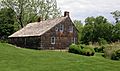
The Brewster House, built around 1665, is the oldest building in Brookhaven. It's in Setauket, the town's first settlement.
-
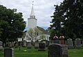
The Caroline Church in Setauket was built in 1729. It is the oldest church still standing in Brookhaven.
-
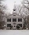
The Miller Place Academy schoolhouse, built around 1834.
-
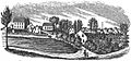
An old sketch of early Patchogue.
-
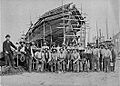
The Mather Shipyard in Port Jefferson in 1884.
-
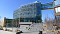
The Simons Center for Geometry and Physics at Stony Brook University.
-
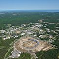
Brookhaven National Laboratory from above.
-
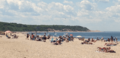
Sunbathers at Cedar Beach on the Long Island Sound.
-
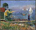
Bathers at Bellport by William Glackens.
See also
 In Spanish: Brookhaven (Nueva York) para niños
