
North Shore (Long Island) facts for kids
The North Shore of Long Island is a beautiful area along the northern coast of Long Island, New York. It borders the Long Island Sound. This area is famous for its amazing wealth and huge, fancy homes. It became super rich around the early 1900s, which is why people started calling it the Gold Coast.
Historically, the Gold Coast included towns like North Hempstead and Oyster Bay in Nassau County. It also included Huntington in Suffolk County. Even the town of Smithtown further east is known for its wealth. The very last Gold Coast mansion to the east is the Geissler Estate. It's located in Fort Salonga, within the Town of Huntington.
The North Shore is a bit hilly because it was shaped by ancient glaciers. Its beaches are also more rocky compared to the flat, sandy beaches of the South Shore, which faces the Atlantic Ocean. You can even find huge rocks called glacial erratics scattered around the area.
Contents
A Look Back: North Shore History
Early Days: The Colonial Era
People first started settling the North Shore in the mid-1600s. At first, much of this land was controlled by the Dutch colony called New Netherland. However, English settlers from the New Haven Colony and Connecticut Colony settled the eastern parts of the North Shore. This changed in 1664 when the English took over New Netherland. At that point, all of Long Island became part of the new Province of New York.
In its early years, the North Shore was mostly farmland. Whaling (hunting whales) was also an important part of the economy. You can still see this history at the Whaling Museum & Education Center in Cold Spring Harbor.
The Gold Coast: A Time of Grand Mansions

During the late 1800s and early 1900s, many people made huge fortunes in industries like steel and transportation. Starting in the early 1890s, incredibly fancy private estates were built on what became known as Long Island's "Gold Coast." More than 500 mansions were built during this time, mostly in an area of about 70 square miles (180 square kilometers).
Among these grand homes were huge castles and chateaux (French castles) that belonged to famous families like the Vanderbilts, Astors, and Whitneys. Other wealthy people like Charles Pratt, J. P. Morgan, and F. W. Woolworth also built homes here. Otto Kahn's Oheka Castle was said to be the second largest private home in the entire United States. It was only smaller than the Biltmore Estate in North Carolina. Some people, like Theodore Roosevelt, chose to build large, comfortable "cottages" instead of formal mansions. His home, Sagamore Hill, is a good example.

The richest people hired the best architects, landscapers, and decorators to design their estates. Famous names included Stanford White and John Russell Pope. The mansions were built in many different styles, such as English Tudor, French Chateau, Georgian, and Mediterranean. Sometimes, entire rooms or buildings were taken apart in Europe and rebuilt on the North Shore!
These grand homes also had amazing features. They often included formal gardens, gazebos, greenhouses, stables, guest houses, swimming pools, and even golf courses and tennis courts. People living on the Gold Coast enjoyed activities like horse riding, fox hunting, polo, yachting, golf, and tennis. They kept their privacy with huge land areas, tall hedges, fences, and private roads.
After the Wars: Changes to the Gold Coast
After World War II, many of the Gold Coast mansions were torn down. Their large estates were divided into smaller plots for new suburban neighborhoods. Out of the original 500 mansions, only about 200 still exist today.
As family fortunes changed, some of the biggest or most famous Gilded Era mansions were given new lives. For example, Daniel Guggenheim's Gould-Guggenheim Estate, Theodore Roosevelt's Sagamore Hill, and William Vanderbilt II's Eagle's Nest became museum homes, conference centers, or resorts. Other estates were used for different purposes. Herbert L. Pratt's home, "The Braes," in Glen Cove, became the Webb Institute. Walter Chrysler's estate, "Forker House," in Kings Point, became the United States Merchant Marine Academy. And U.S. Steel heir Childs Frick's "Clayton" estate is now the Nassau County Museum of Art.
North Shore Geography

The North Shore is known for its many peninsulas (pieces of land almost surrounded by water) and sheltered harbors. The towns of North Hempstead, Oyster Bay, and Huntington own much of this land. This area is famous for keeping many of its old Gold Coast estates. Further east, in the towns of Smithtown and Brookhaven, you'll find similar peninsulas and harbors with towns like Stony Brook and Port Jefferson.
When Long Island splits into two "forks" at its eastern end, the North Shore's hills mostly flatten out. This area, which includes the Town of Riverhead and then Southold, becomes mostly rural. Farming is very important here, especially growing grapes for wineries. This trend started in the 1980s when potato farms were turned into vineyards. Because of this, the North Fork is now the most productive farming area in New York State!
The North Fork is very different from the more famous South Fork, which has the busy Hamptons. The North Fork ends at Orient Point. From there, you can take a ferry to New London, Connecticut, or Block Island, Rhode Island.
Greenport is a village in Southold, located between Orient and Riverhead. It's an important economic center for the North Fork. It's also the eastern end of the Long Island Rail Road's Main Line. The North Fork is also connected to Shelter Island, an island in Peconic Bay. You can reach Shelter Island by a ferry that leaves from Greenport, right next to the train station. There's also a ferry on the south side of Shelter Island that connects to North Haven on the South Fork.
Gold Coast Mansions You Can Still See
Many of the grand Gold Coast estates are still standing today. Some of them are now museums or schools.
- Caumsett, once the home of Marshall Field III
- Coindre Hall
- Delamater-Bevin Mansion
- Greentree
- Harry E. Donnell House
- Hempstead House
- John E. Aldred Estate
- Killenworth
- Nassau County Museum of Art, which used to be The Clayton Estate
- Oheka Castle
- Old Westbury Gardens
- Vanderbilt Museum
- Webb Institute, which was once "The Braes"
- Welwyn Preserve, formerly the Welwyn Estate
- United States Merchant Marine Academy, which was once "Forker House"
Cities, Villages, and Towns on the North Shore
- Asharoken
- Bayville
- Belle Terre
- Brookville
- Centerport
- Centre Island
- Cold Spring Harbor
- Commack
- Cove Neck
- East Norwich
- East Hills
- East Setauket
- Eatons Neck
- Flower Hill
- Fort Salonga
- Glen Cove
- Glen Head
- Great Neck
- Great Neck Estates
- Greenport
- Halesite
- Head of the Harbor
- Huntington
- Huntington Bay
- Jericho
- Kensington
- Kings Park
- Kings Point
- Lake Success
- Lattingtown
- Laurel Hollow
- Locust Valley
- Lloyd Harbor
- Manhasset
- Matinecock
- Mattituck
- Mill Neck
- Mount Sinai
- Muttontown
- Nissequogue
- North Hills
- Northport
- Oyster Bay
- Oyster Bay Cove
- Old Brookville
- Old Field
- Old Westbury
- Orient
- Plainview
- Plandome
- Plandome Manor
- Poquott
- Port Jefferson
- Port Washington
- Rocky Point
- Roslyn
- Roslyn Estates
- Roslyn Harbor
- Roslyn Heights
- Saddle Rock
- Sands Point
- Sea Cliff
- Setauket
- Shoreham
- Smithtown
- Southold
- Stony Brook
- Syosset
- Thomaston
- Upper Brookville
- Wading River
Images for kids
-
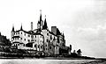
The demolished Beacon Towers estate. This mansion, along with Oheka Castle, helped inspire the famous novel The Great Gatsby.
