South Fork (Long Island) facts for kids
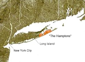
The South Fork is a long piece of land, like a finger, that sticks out into the ocean from Long Island in New York. It's located in the southeastern part of Suffolk County. This area is also home to most of the Hamptons, which are well-known towns. Long Island has another, shorter "finger" to the north called the North Fork.
Contents
Exploring the South Fork's Geography
The South Fork covers all of the Town of East Hampton. It also includes a big part of the Town of Southampton. The huge body of water to its south is the Atlantic Ocean.
Where the Forks Begin
The South Fork and the North Fork separate near Riverhead, New York. This is where the Peconic River flows into Peconic Bay. People often say that Long Island looks like a fish. The two "forks" form the fish's tail! The Native American name for this area is "Paumanok." This name is also used for a long walking trail. The Paumanok Path goes all the way through the South Fork and other parts of Long Island.
Islands Between the Forks
The South Fork and North Fork are separated by several bays. These include Great Peconic Bay, Little Peconic Bay, and Gardiners Bay. In between these two "fingers" of land, you'll find islands. Two of these islands are Gardiners Island and Shelter Island.
New York's Easternmost Point
The very eastern tip of the South Fork is Montauk Point State Park. This park is in the area called Montauk, New York. It's the furthest east you can go in all of New York State! The eastern end of the North Fork, Orient Point, New York, is further west than Montauk Point.
Getting Around the South Fork
You can reach the South Fork in many ways. Most people drive there from the west. But you can also use trains, buses, or even ferries to get around.
Roads for Driving
The main road on the South Fork is Montauk Highway. This road is part of New York State Route 27. It runs through the entire region. There are also many other important roads. For example, Noyac Road runs next to Montauk Highway. It connects North Sea and Sag Harbor.
Sag Harbor can also be reached by other roads. These include the Bridgehampton-Sag Harbor Turnpike from Bridgehampton. There's also Sagg Road from Sagaponack. Wainscott Northwest Road comes from Wainscott. The East Hampton-Sag Harbor Turnpike connects from East Hampton. Many smaller roads are found around East Hampton, the Springs, and Amagansett. Examples are Three Mile Harbor Road and Springs Fireplace Road.
Trains for Travel
The Long Island Rail Road has a line called the Montauk Branch. This train line has stops in many South Fork towns. These include Westhampton, Hampton Bays, Southampton, Bridgehampton, East Hampton, Amagansett, and Montauk. Trains don't run very often most of the time. This is because there is only one track. The best times to take the train are on Fridays. Many trains leave New York City then. On Sundays, many trains go back into the city.
Buses for Local and City Trips
The Hampton Jitney and the Hampton Luxury Liner are bus services. They mostly take people between the South Fork and New York City. For travel within the South Fork, Suffolk County Transit provides local bus service.
Ferries for Island Hopping
You can get directly to Shelter Island from the South Fork. You take the South Ferry to do this. (The North Ferry connects Shelter Island to the North Fork). Sometimes, you can also take a passenger ferry from Montauk. These ferries can go to Block Island, Rhode Island. They also go to New London, Connecticut, and Martha's Vineyard, Massachusetts.
 | Roy Wilkins |
 | John Lewis |
 | Linda Carol Brown |


