Rocky Point, New York facts for kids
Quick facts for kids
Rocky Point, New York
|
|
|---|---|

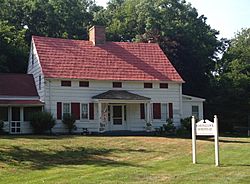
The c. 1721 Noah Hallock homestead, the oldest extant structure in Rocky Point
|
|

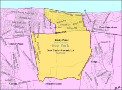
U.S. Census map
|
|
| Country | United States |
| State | New York |
| County | Suffolk |
| Town | Brookhaven |
| Area | |
| • Total | 12.65 sq mi (32.77 km2) |
| • Land | 11.32 sq mi (29.32 km2) |
| • Water | 1.33 sq mi (3.45 km2) |
| Elevation | 194 ft (59 m) |
| Population
(2020)
|
|
| • Total | 13,633 |
| • Density | 1,204.33/sq mi (465.00/km2) |
| Time zone | UTC−05:00 (Eastern Time Zone) |
| • Summer (DST) | UTC−04:00 |
| ZIP Code |
11778
|
| Area code(s) | 631, 934 |
| FIPS code | 36-63319 |
| GNIS feature ID | 0962792 |
Rocky Point is a small community in New York, United States. It is known as a hamlet and a census-designated place (CDP). This means it's a small town-like area that the government tracks for population numbers. Rocky Point is located in the town of Brookhaven, New York. In 2010, about 14,014 people lived there.
Contents
Rocky Point's Past
Rocky Point has an interesting history, especially with radio technology. It was once home to a huge facility called Radio Central. This facility was run by an American radio company called RCA.
Early Radio Communication
RCA started sending radio messages across the Atlantic Ocean from Radio Central. This began on November 5, 1921. These messages used a type of radio wave called longwave.
A few years later, on January 7, 1927, something even more amazing happened. The company AT&T started the very first phone service across the Atlantic. This service connected London, England, with New York. AT&T's main transmitter was right here at Radio Central. The signals were received in Cupar, Scotland.
Radio Central Today
The large Rocky Point site was closed down in 1978. Most of its buildings were taken apart in the 1980s. Today, you can still find concrete ruins and old telephone poles there. The New York State Department of Environmental Conservation now owns the land.
This area is part of the Rocky Point Pine Barrens State Forest. It's also within the Long Island Central Pine Barrens. Because it's in the middle of a forest, many parts of the old radio site look much like they did in the 1920s. It's like a peek into the past!
Hiking Trails and Old Train Stations
The western end of the Paumanok Path hiking trail is in this forest. This trail is about 125 miles long. It stretches all the way to the Montauk Point Light at the eastern tip of Long Island.
Rocky Point also used to have its own train station. The Long Island Rail Road served the hamlet. The station opened in 1895. Trains traveled east to Wading River and west to Port Jefferson and New York City. The train station closed in 1938. Today, a replica of the old station stands there. It houses a Veterans of Foreign Wars (VFW) museum.
Where is Rocky Point?
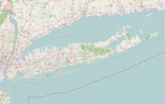
Rocky Point is located on the North Shore of Long Island. This means it's on the northern side of the island, near the water.
According to the United States Census Bureau, the total area of Rocky Point is about 29.3 square kilometers (11.3 square miles). All of this area is land.
People of Rocky Point
In 2010, there were 14,014 people living in Rocky Point. By 2020, the population was 13,633.
Most people living in Rocky Point are White (about 93.7%). Other groups include Black or African American (1.5%), Asian (1.6%), and Native American (0.1%). About 7.0% of the population is Hispanic or Latino.
Many households in Rocky Point have children under 18 living with them. The average household has about 2.89 people. The average family size is 3.34 people.
The median age in Rocky Point is about 36.8 years old. This means half the people are younger than 36.8, and half are older. About 27.2% of the population is under 18 years old.
Famous People from Rocky Point
- Danny Burawa (born 1988), a professional baseball pitcher. He played for the New York Yankees and Atlanta Braves in 2015.
See also
 In Spanish: Rocky Point (Nueva York) para niños
 | Selma Burke |
 | Pauline Powell Burns |
 | Frederick J. Brown |
 | Robert Blackburn |


