Mill Neck, New York facts for kids
Quick facts for kids
Mill Neck, New York
|
||
|---|---|---|
| Incorporated Village of Mill Neck | ||

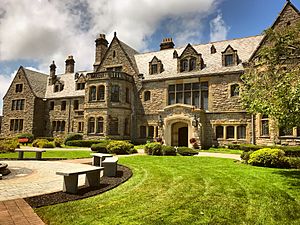
The historic Lillian S. Dodge Estate, commonly known as Mill Neck Manor, in 2018
|
||
|
||

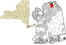
Location in Nassau County and the state of New York.
|
||
| Country | ||
| State | ||
| County | Nassau | |
| Town | Oyster Bay | |
| Incorporated | 1925 | |
| Area | ||
| • Total | 2.94 sq mi (7.61 km2) | |
| • Land | 2.62 sq mi (6.77 km2) | |
| • Water | 0.32 sq mi (0.84 km2) | |
| Elevation | 141 ft (43 m) | |
| Population
(2020)
|
||
| • Total | 1,054 | |
| • Density | 403.06/sq mi (155.60/km2) | |
| Time zone | UTC-5 (Eastern (EST)) | |
| • Summer (DST) | UTC-4 (EDT) | |
| ZIP code |
11765
|
|
| Area codes | 516, 363 | |
| FIPS code | 36-47405 | |
| GNIS feature ID | 0957256 | |
Mill Neck is a small village located in Nassau County, New York. It's on the North Shore of Long Island, within the Town of Oyster Bay. In 2020, about 1,054 people lived there.
Contents
History of Mill Neck
Mill Neck officially became a village in 1925. During the "Gold Coast" era, many large and fancy estates were built here.
The Mill Neck Village Hall is an interesting building. It used to be the train station for the Long Island Rail Road's Mill Neck stop. This train station was part of the Oyster Bay Branch line. It closed in 1998 because not many people were using it anymore. Today, the village hall also has a local Post Office branch inside. The Old Brookville Police Department also has a small office in the building.
Geography and Landscape
Mill Neck covers a total area of about 2.9 square miles (7.6 square kilometers). Most of this area, about 2.6 square miles (6.7 square kilometers), is land. The rest, about 0.3 square miles (0.8 square kilometers), is water.
The highest point in Mill Neck is a place called Mill Hill. This information comes from the United States Environmental Protection Agency and the United States Geological Survey.
Population of Mill Neck
| Historical population | |||
|---|---|---|---|
| Census | Pop. | %± | |
| 1930 | 516 | — | |
| 1940 | 101 | −80.4% | |
| 1950 | 505 | 400.0% | |
| 1960 | 701 | 38.8% | |
| 1970 | 982 | 40.1% | |
| 1980 | 959 | −2.3% | |
| 1990 | 977 | 1.9% | |
| 2000 | 825 | −15.6% | |
| 2010 | 997 | 20.8% | |
| 2020 | 1,054 | 5.7% | |
| U.S. Decennial Census | |||
According to the 2000 census, there were 825 people living in Mill Neck. These people lived in 295 households, and 241 of those were families.
About 34.6% of the households had children under 18 years old living with them. Most households, about 74.9%, were married couples living together. The average household had about 2.80 people.
The population's age was spread out. About 23.3% were under 18 years old. About 16.6% were 65 years old or older. The average age of people in the village was 44 years.
Education in Mill Neck
School Districts
Children living in Mill Neck attend public schools in one of two different school districts. Depending on where they live in the village, they will go to either the Locust Valley Central School District or the Oyster Bay–East Norwich Central School District.
Library Districts
Just like with schools, Mill Neck is also divided between two different library districts. Residents can use either the Locust Valley Library District or the Oyster Bay–East Norwich Library District.
See also
 In Spanish: Mill Neck para niños
 | Janet Taylor Pickett |
 | Synthia Saint James |
 | Howardena Pindell |
 | Faith Ringgold |


