Thomaston, New York facts for kids
Quick facts for kids
Thomaston, New York
|
|
|---|---|
| Incorporated Village of Thomaston | |

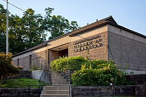
Thomaston Village Hall
|
|

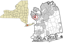
Location in Nassau County and the state of New York.
|
|
| Country | |
| State | |
| County | Nassau |
| Town | North Hempstead |
| Incorporated | October 1, 1931 |
| Founded by | Hunter L. DeLatour Ernest A. Gallagher Henry A. Singley John W. Weight |
| Named for | Thomaston, the ancestral home of Lillian Gilchrist. |
| Area | |
| • Total | 0.40 sq mi (1.05 km2) |
| • Land | 0.40 sq mi (1.05 km2) |
| • Water | 0.00 sq mi (0.00 km2) |
| Elevation | 197 ft (60 m) |
| Population
(2020)
|
|
| • Total | 2,759 |
| • Density | 6,829.21/sq mi (2,638.99/km2) |
| Time zone | UTC-5 (Eastern (EST)) |
| • Summer (DST) | UTC-4 (EDT) |
| ZIP code |
11021
|
| Area code(s) | 516, 363 |
| FIPS code | 36-73605 |
| GNIS feature ID | 0967403 |
Thomaston is a small village located in Nassau County, New York. It is part of the larger Great Neck area on the North Shore of Long Island. In 2020, about 2,759 people lived there.
Contents
History of Thomaston
Thomaston officially became a village on October 1, 1931. Residents voted for this change to help manage their local area better. At first, other nearby communities like University Gardens and Russell Gardens were considered to be part of the new village. However, they decided to form their own separate villages.
The four people who helped create the Village of Thomaston were John W. Weight, Hunter L. DeLatour, Ernest A. Gallagher, and Henry A. Singley.
Thomaston Village Hall
The Thomaston Village Hall was built in 1971. This building was created to give the village government a permanent home. It also helped them work more efficiently. Before the hall was built, meetings often took place in the local firehouse. Village records were kept in the homes of the Village Clerks.
How Thomaston Got Its Name
The name "Thomaston" has been used for this area since the mid-1800s. A famous local person named William R. Grace bought a lot of land here. He later became the Mayor of New York City. Grace named the area "Thomaston" after his wife's family home in Maine. Her name was Lillian Gilchrist.
Later, a part of this area became known as Great Neck Plaza. When the current Village of Thomaston decided to become its own village in 1931, they chose to use the name "Thomaston." This was because members of the Grace family still owned land there.
Geography and Location
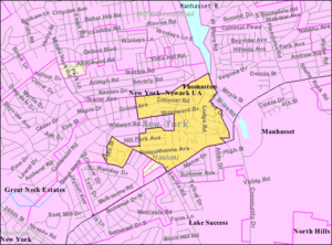
Thomaston covers a total area of about 0.4 square miles (1.05 square kilometers). All of this area is land.
People of Thomaston
| Historical population | |||
|---|---|---|---|
| Census | Pop. | %± | |
| 1940 | 1,159 | — | |
| 1950 | 2,045 | 76.4% | |
| 1960 | 2,767 | 35.3% | |
| 1970 | 2,811 | 1.6% | |
| 1980 | 2,684 | −4.5% | |
| 1990 | 2,612 | −2.7% | |
| 2000 | 2,607 | −0.2% | |
| 2010 | 2,617 | 0.4% | |
| 2020 | 2,759 | 5.4% | |
| U.S. Decennial Census | |||
In 2000, there were 2,607 people living in Thomaston. There were 973 households and 724 families. The population density was about 6,248 people per square mile.
Many families lived in the village. About 34% of households had children under 18. Most households (65%) were married couples. The average household had 2.67 people.
The median age in the village was 42 years old. About 23% of the population was under 18. About 17% were 65 or older.
The median income for a household was $92,706. For families, it was $110,502.
Education in Thomaston
School Districts
Most of Thomaston is served by the Great Neck Union Free School District. This means that most children living in Thomaston go to public schools in Great Neck. A small part of the village's northeastern corner is in the Manhasset Union Free School District. However, all homes in Thomaston are within the Great Neck school area.
Library Districts
Similar to school districts, most of Thomaston is part of the Great Neck Library District. This library provides services to most residents. A small section in the northeast belongs to the Manhasset Library District. The boundaries for both library districts are very similar to the school district boundaries.
Village Infrastructure
Infrastructure includes the basic systems and facilities that a community needs.
Transportation
Roads in Thomaston
One main state road, Northern Boulevard (NY 25A), runs through Thomaston. This road forms the southern border of the village.
Other important roads include Colonial Road, East Shore Road, Grace Avenue, and Shoreward Drive. A small part of Middle Neck Road also goes through the village.
Train Services
The Long Island Rail Road's Port Washington Branch passes through Thomaston. However, there are no train stations directly in the village. The closest train station is Great Neck.
A part of the LIRR's Manhasset Viaduct, a large bridge, is also located within Thomaston.
Bus Services
Thomaston has several bus routes operated by Nassau Inter-County Express (NICE). These include the n20G, n20H, n21, n25, n26, and n57 routes. Most of these buses travel along Northern Boulevard and Middle Neck Road. The n57 bus route briefly goes through the village on Gilchrest Road and Grace Avenue.
Utilities
Natural Gas and Power
National Grid USA provides natural gas to homes and businesses in Thomaston that use it. PSEG Long Island supplies electricity to all homes and businesses in the village. A major power line, the Port Washington to Great Neck Overhead Transmission Line, also runs through Thomaston.
Sewage and Water
Thomaston is connected to sanitary sewers. This system helps manage wastewater. The eastern parts of the village are served by the Great Neck Water Pollution Control District. A small section west of Middle Neck Road is served by the Belgrave Sewer District.
Most of Thomaston gets its water from the Manhasset–Lakeville Water District. However, some areas north of the Long Island Rail Road tracks get water from the Water Authority of Great Neck North. The Manhasset–Lakeville Water District also owns and operates a water tower in the village called the Thomaston Tank.
Notable Person
- Thomas P. DiNapoli – He is the Comptroller of the State of New York. He was also a New York State Assemblyman.
See also
 In Spanish: Thomaston (Nueva York) para niños
 | Audre Lorde |
 | John Berry Meachum |
 | Ferdinand Lee Barnett |


