
Greenport, Suffolk County, New York facts for kids
Quick facts for kids
Greenport, New York
|
|
|---|---|
| Incorporated Village of Greenport | |

Greenport’s harborfront
|
|

U.S. Census Map
|
|

Greenport, New York
Location in Long Island

Greenport, New York
Location in New York

Greenport, New York
Location in the United States
|
|
| Country | |
| State | |
| County | Suffolk |
| Town | Southold |
| First settled | 1682 |
| Incorporated | 1838 |
| Area | |
| • Total | 1.20 sq mi (3.11 km2) |
| • Land | 0.95 sq mi (2.46 km2) |
| • Water | 0.25 sq mi (0.65 km2) |
| Elevation | 10 ft (3 m) |
| Population
(2020)
|
|
| • Total | 2,583 |
| • Density | 2,718.95/sq mi (1,049.94/km2) |
| Time zone | UTC-5 (Eastern (EST)) |
| • Summer (DST) | UTC-4 (EDT) |
| ZIP code |
11944
|
| Area code(s) | 631, 934 |
| FIPS code | 36-30576 |
| GNIS feature ID | 0951759 |
Greenport is a small village located in Suffolk County, on the North Fork of Long Island. It's the only official village in the Town of Southold. In 2020, about 2,583 people lived here.
Greenport was once a very important port known for its fishing and whaling industries. Today, it still has some commercial fishing, but tourism has become a much bigger part of its economy.
Contents
History of Greenport
Greenport was first settled way back in 1682. Before it was called Greenport, it had other names like Winter Harbor, Stirling, and Green Hill. It officially became a village in 1838.
For many years, Greenport was a busy center for whaling and building ships. Since 1844, it has been the end of the line for the Long Island Rail Road on the North Fork. Many old buildings in the village are part of the Greenport Village Historic District, which was added to a special list of historic places in 1986.
Geography of Greenport
Greenport is a small village. It covers about 1.2 square miles (3.1 square kilometers). Most of this area is land, about 1.0 square mile (2.6 square kilometers). The rest, about 0.2 square miles (0.5 square kilometers), is water.
Climate in Greenport
| Climate data for Greenport, Suffolk County, New York (1981–2010 normals, extremes 1958–present) | |||||||||||||
|---|---|---|---|---|---|---|---|---|---|---|---|---|---|
| Month | Jan | Feb | Mar | Apr | May | Jun | Jul | Aug | Sep | Oct | Nov | Dec | Year |
| Record high °F (°C) | 63 (17) |
67 (19) |
76 (24) |
87 (31) |
95 (35) |
92 (33) |
97 (36) |
98 (37) |
94 (34) |
82 (28) |
76 (24) |
72 (22) |
98 (37) |
| Mean daily maximum °F (°C) | 37.3 (2.9) |
39.3 (4.1) |
46.0 (7.8) |
55.3 (12.9) |
65.2 (18.4) |
74.4 (23.6) |
79.9 (26.6) |
79.3 (26.3) |
72.9 (22.7) |
62.7 (17.1) |
53.1 (11.7) |
43.1 (6.2) |
59.0 (15.0) |
| Daily mean °F (°C) | 30.6 (−0.8) |
32.1 (0.1) |
38.6 (3.7) |
47.8 (8.8) |
57.3 (14.1) |
67.1 (19.5) |
72.9 (22.7) |
72.3 (22.4) |
66.0 (18.9) |
55.6 (13.1) |
45.9 (7.7) |
36.4 (2.4) |
51.9 (11.1) |
| Mean daily minimum °F (°C) | 23.9 (−4.5) |
25.0 (−3.9) |
31.2 (−0.4) |
40.2 (4.6) |
49.5 (9.7) |
59.8 (15.4) |
66.0 (18.9) |
65.4 (18.6) |
59.0 (15.0) |
48.4 (9.1) |
38.8 (3.8) |
29.8 (−1.2) |
44.8 (7.1) |
| Record low °F (°C) | −6 (−21) |
−1 (−18) |
0 (−18) |
16 (−9) |
27 (−3) |
36 (2) |
45 (7) |
40 (4) |
30 (−1) |
23 (−5) |
17 (−8) |
−7 (−22) |
−7 (−22) |
| Average precipitation inches (mm) | 3.56 (90) |
3.67 (93) |
4.50 (114) |
4.09 (104) |
3.40 (86) |
4.66 (118) |
3.24 (82) |
4.38 (111) |
3.76 (96) |
4.27 (108) |
3.98 (101) |
3.79 (96) |
47.30 (1,201) |
| Average precipitation days (≥ 0.01 in) | 9.1 | 8.5 | 10.1 | 11.0 | 11.2 | 9.6 | 8.4 | 8.1 | 8.9 | 8.8 | 9.4 | 11.5 | 114.6 |
| Source: NOAA | |||||||||||||
People of Greenport: Demographics
| Historical population | |||
|---|---|---|---|
| Census | Pop. | %± | |
| 1870 | 1,819 | — | |
| 1880 | 2,370 | 30.3% | |
| 1900 | 2,366 | — | |
| 1910 | 3,089 | 30.6% | |
| 1920 | 3,122 | 1.1% | |
| 1930 | 3,062 | −1.9% | |
| 1940 | 3,259 | 6.4% | |
| 1950 | 3,028 | −7.1% | |
| 1960 | 2,608 | −13.9% | |
| 1970 | 2,481 | −4.9% | |
| 1980 | 2,273 | −8.4% | |
| 1990 | 2,070 | −8.9% | |
| 2000 | 2,048 | −1.1% | |
| 2010 | 2,197 | 7.3% | |
| 2020 | 2,583 | 17.6% | |
| U.S. Decennial Census | |||
In 2000, there were 2,048 people living in Greenport. These people lived in 776 households, and 446 of these were families. The village had about 2,143 people per square mile.
About 28.7% of households had children under 18. Around 35.1% were married couples living together. The average household had 2.42 people, and the average family had 3.10 people.
The population's age was spread out. About 23.2% were under 18 years old. Around 22.5% were 65 years or older. The average age in the village was 40 years.
In 2010, the population was made up of:
- 53.6% White
- 34.0% Hispanic
- 10.0% Black
- 0.5% Asian
- 0.1% Native American
- 0.5% Other Race
- 1.5% Two or More Races
Tourism in Greenport
.jpg)
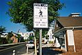
Greenport is a popular place for tourists, especially during the summer. One famous attraction is a 1920s carousel located near the water.
The village is also home to the East End Seaport Museum & Marine Foundation. This museum hosts the yearly Maritime Festival every September. The museum is in the old Greenport Long Island Rail Road station building. The Railroad Museum of Long Island also has a part of its museum in the former freight house nearby. The new train station is still the end of the line for the Long Island Rail Road.
Most of the tourism in Greenport is linked to water activities. It's also close to over 40 vineyards on the East End of Long Island. You can find many small shops, ice cream parlors, and restaurants. Claudio's Restaurants, a very old family-owned restaurant, was located here until 2018. The building itself is over 150 years old.
Education in Greenport
_High_School-1.jpg)
The Greenport Union Free School District provides public education for all students in the village.
Students from Greenport and Greenport West attend schools in this district. Also, students in grades 7–12 from Orient and East Marion come here after attending Oysterponds Elementary School. The main building at 720 Front Street serves as both a Junior and Senior High School. The back part of the building is used for Elementary School and Kindergarten.
Greenport's very first schoolhouse was called the Old Kindergarten Schoolhouse. It was built on the North Road. In 1832, a bigger school was built on Front Street, and students moved there. In 1879, the first kindergarten started, and the old schoolhouse was moved to 4th Avenue and South Street. Students went to kindergarten there until 1932.
In 2005, the Old Kindergarten Schoolhouse was moved again to its current spot on Front Street. With help from the Greenport Improvement Committee and funding from the Village and New York State, it was restored. Now, it's a historic center for the village and a place for community events.
Places of Worship
- Saints Anargyroi, Taxiarchis and Gerasimos Greek Orthodox Church, 702 Main Street, Greenport, NY 11944
- Clinton Memorial A.M.E. Zion Church, 614 3rd Street, Greenport, NY 11944
- First Baptist Church of Greenport, 654 Main Street, Greenport, NY 11944
- Holy Trinity Episcopal Church, 768 Main Street, Greenport, NY 11944
- St. Agnes Church, 523 Front Street, Greenport, NY 11944
- St. Peter's Lutheran Church, 71305 Main Road, Greenport, NY 11944
- Congregation Tifereth Israel, 500 4th Street, Greenport, NY 11944
Transportation in Greenport
Greenport station is the last stop on the Long Island Rail Road's Main Line. From here, you can take a shuttle train to Ronkonkoma. At Ronkonkoma, you can switch to trains that go to New York City.
Greenport is also served by the S92 bus route from Suffolk County Transit. This bus goes from Orient Point Ferry Terminal to East Hampton, passing through Riverhead. The Hampton Jitney's North Fork Line also offers rides to New York City.

In Greenport, you can also take the North Ferry to Shelter Island. From Shelter Island, you can catch another ferry to North Haven.
Gallery
-

Dockside restaurants
-
Art galleries & shopping
-

Farmers Market
-
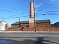
The historic Municipal Light and Water Plant on Moore's Lane.
.JPG)


Sister City
![]() Parrsboro, Nova Scotia, Canada.
Parrsboro, Nova Scotia, Canada.
See also
 In Spanish: Greenport (condado de Suffolk, Nueva York) para niños
