
Fort Salonga, New York facts for kids
Quick facts for kids
Fort Salonga, New York
|
|
|---|---|

Historic marker for the "Battle of Fort Slongo" along eastbound NY 25A.
|
|

U.S. Census map of Fort Salonga
|
|

Fort Salonga, New York
Location in Long Island

Fort Salonga, New York
Location in New York
|
|
| Country | |
| State | |
| County | Suffolk |
| Town | Huntington |
| Named for | Fort Salonga |
| Area | |
| • Total | 13.23 sq mi (34.26 km2) |
| • Land | 9.49 sq mi (24.58 km2) |
| • Water | 3.74 sq mi (9.68 km2) |
| Elevation | 33 ft (10 m) |
| Population
(2020)
|
|
| • Total | 9,652 |
| • Density | 1,016.96/sq mi (392.67/km2) |
| Time zone | UTC-5 (Eastern (EST)) |
| • Summer (DST) | UTC-4 (EDT) |
| ZIP code |
11768
|
| Area code(s) | 631, 934 |
| FIPS code | 36-26946 |
| GNIS feature ID | 0950497 |
Fort Salonga is a community in New York. It is a hamlet and a census-designated place (CDP). This means it's a small area with a name, but it's not officially a town or city.
Fort Salonga is located on the North Shore of Long Island, in Suffolk County. Part of it is in the town of Huntington, and another part is in Smithtown. In 2020, about 9,652 people lived here.
This area is also known as the eastern end of Long Island's historic Gold Coast. This was once a place where many large, fancy estates were built.
Contents
History of Fort Salonga
Revolutionary War and the Fort
During the American Revolutionary War, there was a British fort in this area. It was called Fort Salonga, or sometimes Fort Slongo. It was named after one of the people who helped design it.
One night, American soldiers secretly landed on a nearby beach called Crab Meadow. They moved along the shore and captured the fort. This was an important event in the local history of the war.
Brick Making and Trade
After the American Civil War, the area became known for its rich red clay. This clay was perfect for making bricks. Many brick companies started here, and it became a successful business.
Barges would bring manure (fertilizer) from New York City to Fort Salonga. Farmers from nearby towns would come to get it for their crops. The empty barges would then be filled with bricks to take back to the city.
One of the brick companies was owned by the Brown family in the late 1800s. Their bricks were known as "Brown's Best Bricks," or BBB. The Brown family home, located on Breeze Hill Road, is now the clubhouse for the Indian Hills Country Club. It has been used as a clubhouse since 1963.
How the Hamlet Got Its Name
The name "Fort Salonga" comes from the old British fort from the Revolutionary War. This fort was located near where the towns of Huntington and Smithtown meet. It overlooked the Long Island Sound. Before it was called Fort Salonga, the area was known as Fresh Pond.
Geography of Fort Salonga
Fort Salonga is a fairly large area. It covers about 9.49 square miles (24.58 square kilometers) of land. A small part of it, about 3.74 square miles (9.68 square kilometers), is water.
The community of Fort Salonga also includes the smaller area known as Crab Meadow.
People and Population
In 2020, the population of Fort Salonga was 9,652 people. Most of the people living here are White (96.83%). There are also smaller groups of African American, Native American, and Asian residents. About 2.25% of the population is Hispanic or Latino.
Fort Salonga is considered a wealthy area. In 2000, the average income for a family was about $106,253. Most households were made up of married couples living together. About 37.9% of households had children under 18 living with them.
The median age of people in Fort Salonga was 40 years old. This means half the people were older than 40 and half were younger.
Education in Fort Salonga
Children in Fort Salonga go to public schools in one of two different school districts. This depends on where they live within the community.
- If you live in the part of Fort Salonga that is in the Town of Huntington, you go to schools in the Northport-East Northport Union Free School District.
- If you live in the part of Fort Salonga that is in the Town of Smithtown, you go to schools in the Kings Park Central School District.
The line between these two school districts in Fort Salonga follows a road called Bread and Cheese Hollow Road.
Images for kids
-
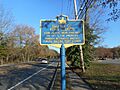
Historic marker for the "Battle of Fort Slongo" along eastbound NY 25A.
-
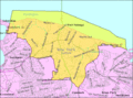
U.S. Census map of Fort Salonga
See also
 In Spanish: Fort Salonga (Nueva York) para niños
