
Belle Terre, New York facts for kids
Quick facts for kids
Belle Terre, New York
|
|
|---|---|
| Incorporated Village of Belle Terre | |
.jpg)
The Belle Terre Gatehouse, a beaux arts structure dating to the first decade of the 1900s.
|
|

U.S. Census Map
|
|

Belle Terre, New York
Location in New York
|
|
| Country | |
| State | |
| County | Suffolk |
| Town | Brookhaven |
| Incorporated | 1931 |
| Area | |
| • Total | 0.89 sq mi (2.29 km2) |
| • Land | 0.89 sq mi (2.29 km2) |
| • Water | 0.00 sq mi (0.00 km2) |
| Elevation | 161 ft (49 m) |
| Population
(2020)
|
|
| • Total | 808 |
| • Density | 912.99/sq mi (352.58/km2) |
| Time zone | UTC−05:00 (Eastern Time Zone) |
| • Summer (DST) | UTC−04:00 |
| ZIP Code |
11777
|
| Area codes | 631, 934 |
| FIPS code | 36-05672 |
| GNIS feature ID | 0943606 |
Belle Terre is a small village in New York, United States. It is located in Suffolk County, on the North Shore of Long Island. The village is part of the Town of Brookhaven. In 2020, the population of Belle Terre was 808 people.
Contents
History of Belle Terre

The land where Belle Terre is located has been known as "Mt. Misery" since the 1600s. The northern tip of this land was called "Mt. Misery Point." The lower part, which is now the nearby village of Port Jefferson, was known as "Mt. Misery Neck."
Early Owners and First Homes
For many years in the 1700s and 1800s, the Strong family owned most of this land. They had a large property called the Oakwood estate. The first known house in what is now Belle Terre was a small shack built in the 1800s. It was built by an African-American man known as Uncle Mott. A local artist named William Moore Davis even painted this house.
Developing a New Community
In 1902, a company called the Port Jefferson Company bought the Oakwood estate. Their plan was to create a fancy waterfront community with about fifty homes. They wanted it to be as nice as the famous "Gold Coast" communities on Long Island.
Dean Alvord, a well-known real estate developer, was chosen to lead the Belle Terre estates. The community officially became a village in 1906. That same year, the Belle Terre Club was built. This was a grand private club right in the middle of the community. Two beautiful structures called pergolas were also built. They offered great views of the waterfront.
Becoming an Official Village
In 1931, Belle Terre officially became an incorporated village. This meant it could govern itself.
Changes Over Time
Sadly, the Belle Terre Club was destroyed in a fire in 1934. The pergolas were also taken down that year because they were too expensive to keep up. Since there was no insurance, the clubhouse was never rebuilt. However, a new country club opened nearby in Port Jefferson in 1956.
During the 1920s and 1930s, the people living in Belle Terre worked together to stop companies from digging up sand and gravel in the area. These companies were causing problems. Before they were stopped in 1931, one company dug a large cove near the tip of the land. Today, this spot is known as Pirates Cove. It's a popular place for boaters in Port Jefferson Harbor.
For many years, Belle Terre was home to Nadia de Navarro Farber. She was a countess who gave a lot of money to the John T. Mather Memorial Hospital in Port Jefferson. She lived in a famous pink mansion in Belle Terre. This mansion was even shown in the 1989 movie She-Devil.
Geography of Belle Terre
Belle Terre covers about 0.9 square miles (2.29 square kilometers) of land. There is no water within the village's official area.
The village is located on the northeastern part of the Mt. Misery peninsula. It has views of both Port Jefferson Harbor and the Long Island Sound. To get to Belle Terre by land, you must go through the neighboring village of Port Jefferson. Port Jefferson is also where Belle Terre residents go for shopping and transportation.
Population and People
| Historical population | |||
|---|---|---|---|
| Census | Pop. | %± | |
| 1940 | 89 | — | |
| 1950 | 120 | 34.8% | |
| 1960 | 295 | 145.8% | |
| 1970 | 678 | 129.8% | |
| 1980 | 826 | 21.8% | |
| 1990 | 839 | 1.6% | |
| 2000 | 832 | −0.8% | |
| 2010 | 792 | −4.8% | |
| 2020 | 808 | 2.0% | |
| U.S. Decennial Census | |||
In 2010, there were 792 people living in Belle Terre. These people lived in 286 households, and 224 of those were families.
Most of the people in Belle Terre were White (92.6%). There were also African American (1.3%), Asian (3.3%), and other races. About 3.9% of the population was Hispanic or Latino.
About 30.8% of households had children under 18 living with them. Most households (72.0%) were married couples. The average household had 2.77 people, and the average family had 3.10 people.
In 2000, the village had about 952 people per square mile. The average age of people in Belle Terre was 45 years old. About 24.8% of the population was under 18.
The average income for a household in the village was $132,155. For families, it was $144,708.
Important Court Case: Belle Terre v. Boraas
Belle Terre is known for a specific law that was challenged in court. This law affected students from Stony Brook University, a nearby college. These students were renting shared homes in the village.
In 1974, a case called Village of Belle Terre v. Boraas went all the way to the Supreme Court of the United States. The Supreme Court decided that the village could have a law that limited how many unrelated people could live together in a house. This law was meant to help keep the village a quiet place for families. The court said it was okay to prevent more than two people who were not related by blood, adoption, or marriage from living and cooking together in a single home.
Images for kids
-
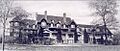
The Belle Terre Club, a grand private clubhouse that stood from 1906 to 1934.
-
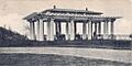
One of the pergolas that overlooked Port Jefferson Harbor before being taken down in 1934.


See also
 In Spanish: Belle Terre (Nueva York) para niños
