Asharoken, New York facts for kids
Quick facts for kids
Asharoken, New York
|
|
|---|---|
| Incorporated Village of Asharoken | |

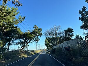
Asharoken Road in the village on October 9, 2022.
|
|

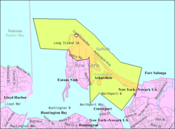
U.S. Census map of Asharoken
|
|
| Country | |
| State | |
| County | Suffolk |
| Town | Huntington |
| Incorporated | 1925 |
| Named for | Chief Asharoken |
| Area | |
| • Total | 6.48 sq mi (16.80 km2) |
| • Land | 1.42 sq mi (3.68 km2) |
| • Water | 5.06 sq mi (13.11 km2) |
| Elevation | 13 ft (4 m) |
| Population
(2020)
|
|
| • Total | 592 |
| • Density | 416.32/sq mi (160.71/km2) |
| Time zone | UTC-5 (Eastern (EST)) |
| • Summer (DST) | UTC-4 (EDT) |
| ZIP Code |
11768
|
| Area code(s) | 631, 934 |
| FIPS code | 36-02737 |
| GNIS feature ID | 0942621 |
Asharoken is a small village located in the Town of Huntington. It is part of Suffolk County, on the North Shore of Long Island in New York. In 2020, about 592 people lived there.
Contents
History of Asharoken
Asharoken became an official village in 1925. This was done so that the local people could have more control over their own area, especially their beaches and roads. This idea is called "home rule," which means a local government can make its own rules about local matters.
The village gets its name from Chief Asharoken. He was the leader of the Matinecock Native American tribe. This tribe lived in the area long before European settlers arrived. In 1656, Chief Asharoken sold the land that is now Asharoken, Eatons Neck, and Northport to the European settlers.
Geography of Asharoken
Asharoken covers about 6.5 square miles (16.8 square kilometers) in total. Most of this area, about 5.1 square miles (13.1 square kilometers), is water. Only about 1.4 square miles (3.68 square kilometers) is land.
The village includes part of a place called Eatons Neck. It also has a long, narrow strip of land, often called Asharoken itself. This strip connects Northport in the southeast to Eaton's Neck in the northwest. It also separates Northport Bay from Long Island Sound.
Population Changes in Asharoken
| Historical population | |||
|---|---|---|---|
| Census | Pop. | %± | |
| 1930 | 98 | — | |
| 1940 | 48 | −51.0% | |
| 1950 | 116 | 141.7% | |
| 1960 | 253 | 118.1% | |
| 1970 | 540 | 113.4% | |
| 1980 | 635 | 17.6% | |
| 1990 | 807 | 27.1% | |
| 2000 | 625 | −22.6% | |
| 2010 | 654 | 4.6% | |
| 2020 | 592 | −9.5% | |
| U.S. Decennial Census | |||
Over the years, the number of people living in Asharoken has changed. In 1930, there were 98 residents. The population grew quite a bit by 1990, reaching 807 people. By 2020, the population was 592.
Famous People from Asharoken
Many well-known people have lived in or spent time in Asharoken, including:
- Marlene Dietrich – a famous actress and singer.
- Jackie Gleason – a popular comedian who spent many summers here.
- Rube Goldberg – a cartoonist known for his complex inventions. He lived here for most of his life.
- Bud Harrelson – a baseball player who was the starting shortstop for the 1969 "Miracle Mets" team that won the World Series.
- Eugene O'Neill – a famous playwright, who lived here in 1931.
- Antoine de Saint-Exupéry – the author of the beloved book The Little Prince. He wrote the book at the Delamater-Bevin Mansion in Asharoken in 1942.
Asharoken Police Department
The Village of Asharoken has its own police department. This police force is mainly paid for by taxes from the people who live in the village. The Asharoken Police Department is known for being strict about speeding. In 2003, their four officers gave out 1,000 tickets for speeding. This was a very high number compared to nearby towns.
By 2009, the police force had grown to 11 officers, plus a supervising officer. They also had five police cars and a boat to patrol both land and water. In December 2010, the police department received a new boat for marine patrols.
See also
 In Spanish: Asharoken para niños
 | Misty Copeland |
 | Raven Wilkinson |
 | Debra Austin |
 | Aesha Ash |


