Nissequogue, New York facts for kids
Quick facts for kids
Nissequogue, New York
|
|
|---|---|
| Incorporated Village of Nissequogue | |

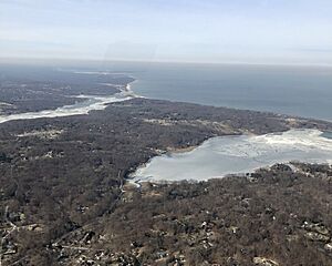
Nissequogue and its surroundings, as seen from the air in 2019, looking northwest.
|
|

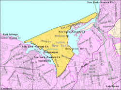
U.S. Census map of Nissequogue
|
|
| Country | |
| State | |
| County | Suffolk |
| Town | Smithtown |
| Incorporated | 1925 |
| Area | |
| • Total | 4.03 sq mi (10.44 km2) |
| • Land | 3.81 sq mi (9.86 km2) |
| • Water | 0.22 sq mi (0.57 km2) |
| Elevation | 85 ft (26 m) |
| Population
(2020)
|
|
| • Total | 1,564 |
| • Density | 410.71/sq mi (158.58/km2) |
| Time zone | UTC-5 (Eastern (EST)) |
| • Summer (DST) | UTC-4 (EDT) |
| ZIP code |
11780
|
| Area codes | 631, 934 |
| FIPS code | 36-51286 |
| GNIS feature ID | 0958622 |
Nissequogue is a small village located in Suffolk County, New York, in the United States. It's found on the North Shore of Long Island. In 2020, about 1,564 people lived here.
The full name of the village is the Incorporated Village of Nissequogue. It is completely inside the Town of Smithtown.
Contents
History of Nissequogue
Nissequogue officially became a village in 1925. This process is called incorporation.
In the early 1970s, the Nissequogue Village Hall opened. It was set up in an old school building called the Moriches Road Schoolhouse. This happened when James Donahue was the Mayor. In 2017, the Village Hall was named after him to honor his work.
In 1973, Mayor Donahue and his team started the Village of Nissequogue Fire Department. They also bought the land for the fire station. The village created its own fire department because the Saint James Fire Department, which used to serve Nissequogue, wanted to charge more for their services.
As of July 2022, the Mayor of Nissequogue is Richard B. Smith. He is a relative of Richard Smith (Smythe), who was the first English settler in the village.
Geography of Nissequogue
Nissequogue covers about 4.0 square miles (10.4 square kilometers) in total. Most of this area, about 3.8 square miles (9.8 square kilometers), is land. The rest, about 0.2 square miles (0.57 square kilometers), is water.
To the west of the village is the Nissequogue River, which the village is named after. To the north, you'll find Long Island Sound. To the east is Stony Brook Harbor. A main road called Moriches Road runs through the middle of the village.
All of Nissequogue uses the St. James Post Office. This post office is located in the nearby area of St. James. The ZIP code for Nissequogue is 11780.
Nissequogue is known for keeping its natural Long Island landscape beautiful. The village has special rules to protect its unique scenery. For example, properties must be at least two acres when divided. Also, there are no industrial businesses allowed within the village.
Population of Nissequogue
| Historical population | |||
|---|---|---|---|
| Census | Pop. | %± | |
| 1930 | 174 | — | |
| 1940 | 188 | 8.0% | |
| 1950 | 219 | 16.5% | |
| 1960 | 332 | 51.6% | |
| 1970 | 1,120 | 237.3% | |
| 1980 | 1,462 | 30.5% | |
| 1990 | 1,620 | 10.8% | |
| 2000 | 1,543 | −4.8% | |
| 2010 | 1,749 | 13.4% | |
| 2020 | 1,564 | −10.6% | |
| U.S. Decennial Census | |||
In 2000, a census showed that 1,543 people lived in the village. There were 533 households, which are groups of people living together. Out of these, 455 were families.
Most of the people living in Nissequogue were White (97.34%). A small number were Asian (0.97%) or African American (0.13%). About 1.56% were from two or more races. People of Hispanic or Latino background made up 2.92% of the population.
About 36% of households had children under 18 living with them. Most households (79.2%) were married couples. About 12.2% of households were single individuals.
The average age in the village was 42 years old. About 25.6% of the population was under 18. About 11.9% were 65 years old or older.
Parks and Recreation in Nissequogue
Nissequogue has several popular places for outdoor activities and fun. These include Long Beach Town Park, Short Beach, and The David Weld Sanctuary. Another interesting spot is The Boney Lane Farm, which is located on what used to be called Boney Lane, now known as Short Beach Road.
See also
 In Spanish: Nissequogue para niños
 | Jewel Prestage |
 | Ella Baker |
 | Fannie Lou Hamer |


